

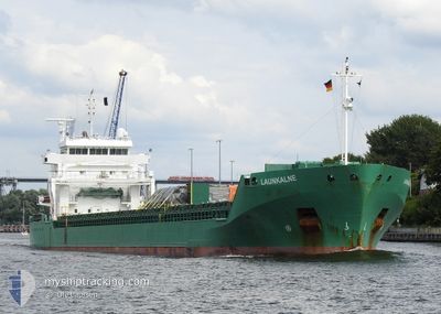
LAUNKALNE
General Cargo

Current Trip
| Time Travelled | 2 days |
|---|---|
| Remaining Time | --- |
| Distance Travelled | 470.94 nm |
| Remaining Distance | 4.61 nm |
| AVG Speed | 12.5 Knots |
| MAX Speed | 13.5 Knots |
| AVG Wind | 16 knots |
| MAX Wind | 19 knots |
| MIN Temp | 0.1°C / 32.18°F |
| MAX Temp | 5.4°C / 41.72°F |
| Draught | 4.9 m |
| Position Received | 1 m ago |
Current Position
| Longitude | --- |
|---|---|
| Latitude | --- |
| Status | Under way using engine |
| Speed | 3.5 Knots |
| Course | 36° |
| Area | Gulf of Riga |
| Station | T-AIS |
| Position Received | 1 m ago |
Information
The current position of LAUNKALNE is in Gulf of Riga with coordinates 58.31700° / 24.41609° as reported on 2025-03-23 10:58 by AIS to our vessel tracker app. The vessel's current speed is 3.5 Knots and is heading at the port of PARNU. The estimated time of arrival as calculated by MyShipTracking vessel tracking app is 2025-03-22 23:00 LT
The vessel LAUNKALNE (IMO: 9504114, MMSI: 210388000) is a General Cargo that was built in 2010 ( 15 years old ). It's sailing under the flag of [CY] Cyprus.
In this page you can find informations about the vessels current position, last detected port calls, and current voyage information. If the vessels is not in coverage by AIS you will find the latest position.
The current position of LAUNKALNE is detected by our AIS receivers and we are not responsible for the reliability of the data. The last position was recorded while the vessel was in Coverage by the Ais receivers of our vessel tracking app.
The current draught of LAUNKALNE as reported by AIS is 4.9 meters
Weather
| Temperature | 4.7°C / 40.46°F |
|---|---|
| Wind Speed | 9 knots |
| Direction | 119° ESE |
| Pressure | 1030.5 hPa |
| Humidity | 47.5 % |
| Cloud Coverage | 24 % |


Featured Company
Last Port Calls
| Port | Arrival | Departure | Time In Port |
|---|---|---|---|
| 2025-03-19 09:16 | 2025-03-21 07:52 | 1 d | |
| 2025-03-16 20:58 | 2025-03-17 18:59 | 22 h | |
| 2025-03-13 06:32 | 2025-03-14 20:38 | 1 d | |
| 2025-03-10 01:55 | 2025-03-11 04:52 | 1 d | |
| 2025-03-07 06:16 | 2025-03-07 18:53 | 12 h | |
| 2025-03-04 08:58 | 2025-03-04 21:40 | 12 h | |
| 2025-03-01 10:09 | 2025-03-02 17:37 | 1 d | |
| 2025-02-22 21:17 | 2025-02-25 16:01 | 2 d | |
| 2025-02-21 07:48 | 2025-02-22 10:48 | 1 d | |
| 2025-02-18 06:24 | 2025-02-18 18:47 | 12 h |
Last Trips
| Origin | Departure | Destination | Arrival | Distance | |
|---|---|---|---|---|---|
| 2025-03-17 18:59 | 2025-03-19 09:16 | 468.92 nm | |||
| 2025-03-14 20:38 | 2025-03-16 20:58 | 475.12 nm | |||
| 2025-03-11 04:52 | 2025-03-13 06:32 | 582.75 nm | |||
| 2025-03-07 18:53 | 2025-03-10 01:55 | 701.27 nm | |||
| 2025-03-04 21:40 | 2025-03-07 06:16 | 588.26 nm | |||
| 2025-03-02 17:37 | 2025-03-04 08:58 | 472.09 nm | |||
| 2025-02-25 16:01 | 2025-03-01 10:09 | 744.89 nm | |||
| 2025-02-22 10:48 | 2025-02-22 21:17 | 97.91 nm | |||
| 2025-02-18 18:47 | 2025-02-21 07:48 | 701.29 nm | |||
| 2025-02-12 14:30 | 2025-02-18 06:24 | 1203.47 nm |
Events
| Time | Event | Details | Position / Dest | Info |
|---|---|---|---|---|
| 2025-03-23 10:57 | START Moving | 4.38 nm, South West of PARNU |
58.31650 / 24.41542
EEPAR
|
Speed: 3.2 kn Course: 36° |
| 2025-03-23 10:06 | Status Changed | Under way using engine At anchor |
58.31179 / 24.42300
EEPAR
|
Speed: 0.9 kn Course: 100° |
| 2025-03-22 19:59 | Status Changed | At anchor Under way using engine |
58.31097 / 24.42206
EEPAR
|
Speed: 0.1 kn Course: 50° |
| 2025-03-22 19:59 | STOP Moving | 4.58 nm, South West of PARNU |
58.31097 / 24.42206
EEPAR
|
Speed: 0.3 kn Course: 51° |
| 2025-03-22 17:34 | Change Sea Area | Estonian part of the Gulf of Riga Swedish part of the Baltic Sea |
57.95213 / 23.87077
Gulf of Riga
EEPAR
|
Speed: 13 kn Course: 80.7° |
| 2025-03-22 17:33 | IN Coverage |
57.95213 / 23.87077
Gulf of Riga
EEPAR
|
Speed: 13 kn Course: 80.7° |
|
| 2025-03-22 04:46 | Status Changed | Default Under way using engine |
56.99601 / 19.11255
EEPAR
|
Speed: 13 kn Course: 63.6° |
| 2025-03-22 04:40 | OUT of Coverage |
56.98751 / 19.07972
Baltic Sea
EEPAR
|
Speed: 13 kn Course: 63.6° |
|
| 2025-03-22 04:39 | Status Changed | Under way using engine Default |
56.98585 / 19.07372
EEPAR
|
Speed: 12.9 kn Course: 64° |
| 2025-03-22 04:18 | Status Changed | Default Under way using engine |
56.95049 / 18.94794
EEPAR
|
Speed: 12.9 kn Course: 63.5° |