

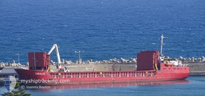
KORALLE
General Cargo

Current Trip
UAILK
| Time Travelled | 10 days |
|---|---|
| Remaining Time | --- |
| Distance Travelled | 1065.17 nm |
| Remaining Distance | --- |
| AVG Speed | 6.5 Knots |
| MAX Speed | 8.2 Knots |
| AVG Wind | 5 knots |
| MAX Wind | 21 knots |
| MIN Temp | 10.6°C / 51.08°F |
| MAX Temp | 21.2°C / 70.16°F |
| Draught | 4.7 m |
| Position Received | 1 m ago |
Current Position
| Longitude | --- |
|---|---|
| Latitude | --- |
| Status | Under way sailing |
| Speed | |
| Course | 269° |
| Area | Sea of Marmara |
| Station | T-AIS |
| Position Received | 1 m ago |
Information
The current position of KORALLE is in Sea of Marmara with coordinates 40.97603° / 28.91655° as reported on 2025-03-30 22:34 by AIS to our vessel tracker app. The vessel's current speed is 0 Knots
The vessel KORALLE (IMO: 8415201, MMSI: 577599000) is a General Cargo that was built in 1985 ( 40 years old ). It's sailing under the flag of [VU] Vanuatu.
In this page you can find informations about the vessels current position, last detected port calls, and current voyage information. If the vessels is not in coverage by AIS you will find the latest position.
The current position of KORALLE is detected by our AIS receivers and we are not responsible for the reliability of the data. The last position was recorded while the vessel was in Coverage by the Ais receivers of our vessel tracking app.
The current draught of KORALLE as reported by AIS is 4.7 meters
Weather
| Temperature | 10.6°C / 51.08°F |
|---|---|
| Wind Speed | 5 knots |
| Direction | 21° NNE |
| Pressure | 1009 hPa |
| Humidity | 90 % |
| Cloud Coverage | 50 % |


Featured Company
Events
| Time | Event | Details | Position / Dest | Info |
|---|---|---|---|---|
| 2025-03-30 08:58 | STOP Moving | 1.07 nm, East of ZEYTINBURNU |
40.97625 / 28.91621
UAILK
|
Speed: 0.3 kn Course: 255° |
| 2025-03-30 06:14 | START Moving | 0.74 nm, West of KARTAL |
40.87789 / 29.18838
UAILK
|
Speed: 4.1 kn Course: 196° |
| 2025-03-29 07:30 | STOP Moving | 0.61 nm, West of KARTAL |
40.88047 / 29.19055
UAILK
|
Speed: 0.2 kn Course: 357° |
| 2025-03-29 02:22 | IN Coverage |
40.80400 / 28.49191
Sea of Marmara
|
Speed: 7 kn Course: 80.1° |
|
| 2025-03-28 10:59 | OUT of Coverage |
40.21001 / 26.45164
Sea of Marmara
|
Speed: 6.2 kn Course: 79.5° |
|
| 2025-03-28 08:27 | Detected in Sea | Turkish part of the Sea of Marmara |
40.05754 / 26.31384
Sea of Marmara
|
Speed: 6.2 kn Course: 34° |
| 2025-03-28 08:27 | IN Coverage |
40.05754 / 26.31384
Sea of Marmara
|
Speed: 6.2 kn Course: 34° |
|
| 2025-03-27 20:08 | OUT of Coverage |
39.56049 / 25.98783
Aegean Sea
|
Speed: 7.2 kn Course: 6.8° |
|
| 2025-03-27 16:34 | Change Sea Area | Turkish part of the Aegean Sea Greek part of the Aegean Sea |
39.42896 / 26.34710
Aegean Sea
|
Speed: 7.2 kn Course: 291.1° |
| 2025-03-27 15:53 | IN Coverage |
39.38830 / 26.43034
Aegean Sea
|
Speed: 7 kn Course: 330.7° |