
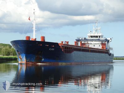
KLARA
General Cargo
Current Trip
| Time Travelled | 3 days |
|---|---|
| Remaining Time | 4 days |
| Distance Travelled | 818.12 nm |
| Remaining Distance | 904.50 nm |
| AVG Speed | 10 Knots |
| MAX Speed | 13.9 Knots |
| AVG Wind | 9.5 knots |
| MAX Wind | 17.9 knots |
| MIN Temp | 12.9°C / 55.22°F |
| MAX Temp | 18.3°C / 64.94°F |
| Draught | 6 m |
| Position Received | 1 m ago |
Current Position
| Longitude | 4.26391° |
|---|---|
| Latitude | 52.88321° |
| Status | Under way using engine |
| Speed | 10.1 Knots |
| Course | 28.4° |
| Area | North Sea |
| Station | T-AIS |
| Position Received | 1 m ago |
Info
Information
The current position of KLARA is in North Sea with coordinates 52.88321° / 4.26391° as reported on 2024-05-13 03:33 by AIS to our vessel tracker app. The vessel's current speed is 10.1 Knots and is heading at the port of NORRKOPING. The estimated time of arrival as calculated by MyShipTracking vessel tracking app is 2024-05-17 03:44 LT
The vessel KLARA (IMO: 9507130, MMSI: 248971000) is a General Cargo that was built in 2010 ( 14 years old ). It's sailing under the flag of [MT] Malta.
In this page you can find informations about the vessels current position, last detected port calls, and current voyage information. If the vessels is not in coverage by AIS you will find the latest position.
The current position of KLARA is detected by our AIS receivers and we are not responsible for the reliability of the data. The last position was recorded while the vessel was in Coverage by the Ais receivers of our vessel tracking app.
The current draught of KLARA as reported by AIS is 6 meters
Weather
| Temperature | 13.5°C / 56.3°F |
|---|---|
| Wind Speed | 12 knots |
| Direction | 145° SE |
| Pressure | 1009.4 hPa |
| Humidity | 92.6 % |
| Cloud Coverage | 77 % |
Featured Company
Last Port Calls
| Port | Arrival | Departure | Time In Port |
|---|---|---|---|
| 2024-05-08 09:06 | 2024-05-09 18:38 | 1 d | |
| 2024-05-05 13:16 | 2024-05-06 20:10 | 1 d | |
| 2024-05-01 10:09 | 2024-05-02 16:14 | 1 d | |
| 2024-04-21 04:15 | 2024-04-23 08:36 | 2 d | |
| 2024-04-17 18:38 | 2024-04-18 21:39 | 1 d | |
| 2024-04-15 17:03 | 2024-04-15 17:07 | 3 m | |
| 2024-04-14 20:26 | 2024-04-15 16:11 | 19 h | |
| 2024-04-14 19:22 | 2024-04-14 19:27 | 5 m | |
| 2024-04-11 14:27 | 2024-04-12 19:46 | 1 d | |
| 2024-04-07 03:05 | 2024-04-09 09:37 | 2 d |
Most Visited Ports (Last year)
| Port | Arrivals | |
|---|---|---|
| 26 | ||
| 11 | ||
| 10 | ||
| 3 | ||
| 3 | ||
| 3 |
Last Trips
| Origin | Departure | Destination | Arrival | Distance | |
|---|---|---|---|---|---|
| 2024-05-06 21:10 | 2024-05-08 11:06 | 403.31 nm | |||
| 2024-05-02 18:14 | 2024-05-05 14:16 | 636.33 nm | |||
| 2024-04-23 11:36 | 2024-05-01 12:09 | 1854.02 nm | |||
| 2024-04-18 23:39 | 2024-04-21 07:15 | 562.30 nm | |||
| 2024-04-15 20:07 | 2024-04-17 20:38 | 530.62 nm | |||
| 2024-04-15 19:11 | 2024-04-15 20:03 | 6.83 nm | |||
| 2024-04-14 22:27 | 2024-04-14 23:26 | 3.10 nm | |||
| 2024-04-12 21:46 | 2024-04-14 22:22 | 538.46 nm | |||
| 2024-04-09 12:37 | 2024-04-11 16:27 | 577.25 nm | |||
| 2024-04-04 12:40 | 2024-04-07 06:05 | 572.08 nm |
Events
| Time | Event | Details | Position / Dest | Info |
|---|---|---|---|---|
| 2024-05-13 03:16 | Status Changed | Under way using engine Default |
52.84254 / 4.22492
NORRKOPING
|
Speed: 9.6 kn Course: 35° |
| 2024-05-13 03:16 | IN Coverage |
52.84254 / 4.22492
North Sea
NORRKOPING
|
Speed: 10 kn Course: 34.1° |
|
| 2024-05-12 20:25 | Status Changed | Default Under way using engine |
52.05887 / 3.00059
NORRKOPING
|
Speed: 10.7 kn Course: 36.7° |
| 2024-05-12 20:23 | OUT of Coverage |
52.05620 / 2.99709
North Sea
NORRKOPING
|
Speed: 10.7 kn Course: 36.7° |
|
| 2024-05-12 18:37 | Change Sea Area | Dutch part of the North Sea Belgian part of the North Sea |
51.81203 / 2.65293
North Sea
NORRKOPING
|
Speed: 11.4 kn Course: 40.4° |
| 2024-05-12 16:38 | Change Sea Area | Belgian part of the North Sea French part of the North Sea |
51.50193 / 2.27528
North Sea
NORRKOPING
|
Speed: 12.1 kn Course: 25.4° |
| 2024-05-12 13:17 | Change Sea Area | French part of the North Sea French part of the English Channel |
51.00504 / 1.60448
North Sea
NORRKOPING
|
Speed: 11.4 kn Course: 54.9° |
| 2024-05-12 10:47 | Status Changed | Under way using engine Default |
50.64904 / 1.28980
NORRKOPING
|
Speed: 10 kn Course: 50° |
| 2024-05-12 10:45 | Status Changed | Default Under way using engine |
50.64421 / 1.28097
NORRKOPING
|
Speed: 9.9 kn Course: 49.7° |
| 2024-05-12 10:44 | Status Changed | Under way using engine Default |
50.64305 / 1.27863
NORRKOPING
|
Speed: 9.9 kn Course: 50° |