
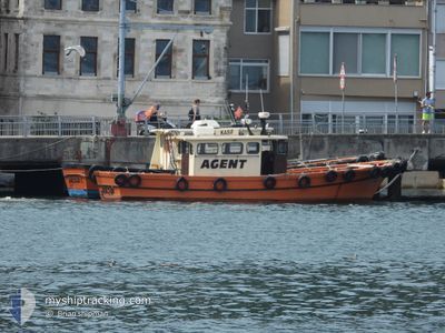
KASIF
Other Type
Current Trip
| Trip Time | 5 h, 27 mins |
|---|---|
| Trip Distance | 11.76 nm |
| AVG Speed | 7.8 Knots |
| MAX Speed | 10 Knots |
| Draught | 0 m |
| AVG Wind | 5.9 knots |
| MAX Wind | 7.9 knots |
| MIN Temp | 14.9°C / 58.82°F |
| MAX Temp | 17.6°C / 63.68°F |
| Position Received | 15 h, 17 m ago |
Current Position
| Longitude | 29.05522° |
|---|---|
| Latitude | 41.16417° |
| Status | Default |
| Speed | 9.2 Knots |
| Course | 244.6° |
| Area | Sea of Marmara |
| Station | T-AIS |
| Position Received | 15 h, 17 m ago |
Info
Information
The current position of KASIF is in Sea of Marmara with coordinates 41.16417° / 29.05522° as reported on 2024-05-22 20:31 by AIS to our vessel tracker app. The vessel's current speed is 9.2 Knots and is currently inside the port of ISTANBUL.
The vessel KASIF (MMSI: 271010239) is a Other Type It's sailing under the flag of [TR] Turkey.
In this page you can find informations about the vessels current position, last detected port calls, and current voyage information. If the vessels is not in coverage by AIS you will find the latest position.
The current position of KASIF is detected by our AIS receivers and we are not responsible for the reliability of the data. The last position was recorded while the vessel was in Coverage by the Ais receivers of our vessel tracking app.
Weather
| Temperature | 15.1°C / 59.18°F |
|---|---|
| Wind Speed | 6 knots |
| Direction | 68° ENE |
| Pressure | 1011.2 hPa |
| Humidity | 90.7 % |
| Cloud Coverage | --- |
Featured Company
Last Port Calls
| Port | Arrival | Departure | Time In Port |
|---|---|---|---|
| 2024-05-22 23:25 | |||
| 2024-05-19 19:32 | 2024-05-22 17:58 | 2 d | |
| 2024-05-16 09:16 | 2024-05-19 19:19 | 3 d | |
| 2024-05-16 05:32 | 2024-05-16 07:23 | 1 h | |
| 2024-05-14 12:46 | 2024-05-16 03:20 | 1 d | |
| 2024-05-09 17:52 | 2024-05-14 09:12 | 4 d | |
| 2024-05-09 13:08 | 2024-05-09 15:09 | 2 h | |
| 2024-05-06 20:15 | 2024-05-09 10:51 | 2 d | |
| 2024-05-06 14:22 | 2024-05-06 17:34 | 3 h | |
| 2024-04-28 06:00 | 2024-05-06 10:58 | 8 d |
Most Visited Ports (Last year)
| Port | Arrivals | |
|---|---|---|
| 23 | ||
| 9 | ||
| 1 |
Last Trips
| Origin | Departure | Destination | Arrival | Distance | |
|---|---|---|---|---|---|
| 2024-05-22 17:58 | 2024-05-22 23:25 | 11.76 nm | |||
| 2024-05-19 19:19 | 2024-05-19 19:32 | 1.94 nm | |||
| 2024-05-16 07:23 | 2024-05-16 09:16 | 8.05 nm | |||
| 2024-05-16 03:20 | 2024-05-16 05:32 | 5.86 nm | |||
| 2024-05-14 09:12 | 2024-05-14 12:46 | 7.96 nm | |||
| 2024-05-09 15:09 | 2024-05-09 17:52 | 7.61 nm | |||
| 2024-05-09 10:51 | 2024-05-09 13:08 | 14.85 nm | |||
| 2024-05-06 17:34 | 2024-05-06 20:15 | 9.23 nm | |||
| 2024-05-06 10:58 | 2024-05-06 14:22 | 10.88 nm | |||
| 2024-04-28 05:42 | 2024-04-28 06:00 | 2.72 nm |
Events
| Time | Event | Details | Position / Dest | Info |
|---|---|---|---|---|
| 2024-05-22 20:31 | OUT of Coverage |
41.16417 / 29.05522
Sea of Marmara
[TR] ISTANBUL
|
Speed: 9.2 kn Course: 244.6° |
|
| 2024-05-22 20:25 | PORT ARRIVAL |
|
41.17213 / 29.06938
[TR] ISTANBUL
|
Speed: 6.6 kn Course: 240.8° |
| 2024-05-22 19:55 | Change Sea Area | Turkish part of the Sea of Marmara Turkish part of the Black Sea |
41.23341 / 29.12800
Sea of Marmara
|
Speed: 9.5 kn Course: 201.9° |
| 2024-05-22 19:46 | Change Sea Area | Turkish part of the Black Sea Turkish part of the Sea of Marmara |
41.23969 / 29.12511
Black Sea
|
Speed: 5.9 kn Course: 35.4° |
| 2024-05-22 19:37 | Change Sea Area | Turkish part of the Sea of Marmara Turkish part of the Black Sea |
41.23517 / 29.11891
Sea of Marmara
|
Speed: 0.9 kn Course: 164.7° |
| 2024-05-22 19:23 | IN Coverage |
41.25051 / 29.09369
Black Sea
|
Speed: 9.9 kn Course: 114.2° |
|
| 2024-05-22 15:40 | OUT of Coverage |
41.26058 / 29.07674
Black Sea
|
Speed: 8.2 kn Course: 284.2° |
|
| 2024-05-22 15:23 | Change Sea Area | Turkish part of the Black Sea Turkish part of the Sea of Marmara |
41.23918 / 29.11502
Black Sea
|
Speed: 8 kn Course: 330.4° |
| 2024-05-22 14:58 | PORT DEPARTURE |
|
41.21923 / 29.11392
|
Speed: 7.9 kn Course: 42.2° |
| 2024-05-22 14:40 | IN Coverage |
41.16277 / 29.05224
Sea of Marmara
[TR] ISTANBUL
|
Speed: 8 kn Course: 57.2° |