
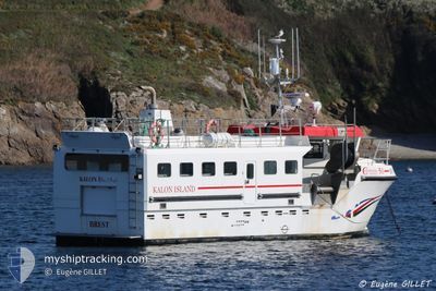
KALON ISLAND
Fishing
Current Trip
Unknown
| Time Travelled | 10 days |
|---|---|
| Remaining Time | --- |
| Distance Travelled | 58.86 nm |
| Remaining Distance | --- |
| AVG Speed | 5.4 Knots |
| MAX Speed | 9.3 Knots |
| AVG Wind | 10.4 knots |
| MAX Wind | 17 knots |
| MIN Temp | 12.1°C / 53.78°F |
| MAX Temp | 13.9°C / 57.02°F |
| Draught | 0 m |
| Position Received | 4 d ago |
Current Position
| Longitude | 4.06757° |
|---|---|
| Latitude | 42.97164° |
| Status | Moored |
| Speed | 5.9 Knots |
| Course | 141.9° |
| Area | Mediterranean Sea - Western Basin |
| Station | T-AIS |
| Position Received | 4 d ago |
Info
Information
The current position of KALON ISLAND is in Mediterranean Sea - Western Basin with coordinates 42.97164° / 4.06757° as reported on 2024-04-25 14:37 by AIS to our vessel tracker app. The vessel's current speed is 5.9 Knots
The vessel KALON ISLAND (IMO: 8596732, MMSI: 227813320) is a Fishing It's sailing under the flag of [FR] France.
In this page you can find informations about the vessels current position, last detected port calls, and current voyage information. If the vessels is not in coverage by AIS you will find the latest position.
The current position of KALON ISLAND is detected by our AIS receivers and we are not responsible for the reliability of the data. The last position was recorded while the vessel was in Coverage by the Ais receivers of our vessel tracking app.
Weather
| Temperature | 13.5°C / 56.3°F |
|---|---|
| Wind Speed | 6 knots |
| Direction | 230° SW |
| Pressure | 1008.8 hPa |
| Humidity | 61 % |
| Cloud Coverage | 29 % |
Featured Company
Most Visited Ports (Last year)
| Port | Arrivals | |
|---|---|---|
| 2 |
Last Trips
| Origin | Departure | Destination | Arrival | Distance |
|---|
Events
| Time | Event | Details | Position / Dest | Info |
|---|---|---|---|---|
| 2024-04-25 14:37 | OUT of Coverage |
42.97164 / 4.06757
Mediterranean Sea - Western Basin
|
Speed: 5.9 kn Course: 141.9° |
|
| 2024-04-25 14:01 | IN Coverage |
43.01729 / 4.01609
Mediterranean Sea - Western Basin
|
Speed: 5.9 kn Course: 137.9° |
|
| 2024-04-20 01:22 | OUT of Coverage |
43.38697 / 3.92068
Mediterranean Sea - Western Basin
|
Speed: 9.7 kn Course: 273.1° |
|
| 2024-04-19 23:52 | IN Coverage |
43.34909 / 3.98797
Mediterranean Sea - Western Basin
|
Speed: 1.3 kn Course: 351.5° |
|
| 2024-04-19 22:14 | OUT of Coverage |
43.30920 / 4.06669
Mediterranean Sea - Western Basin
|
Speed: 4.6 kn Course: 302.8° |
|
| 2024-04-19 21:09 | IN Coverage |
43.27521 / 4.10861
Mediterranean Sea - Western Basin
|
Speed: 5.8 kn Course: 353.2° |