

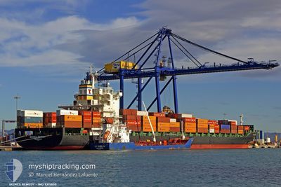
IRENES REMEDY
Container Ship

Current Trip
| Time Travelled | 1 day |
|---|---|
| Remaining Time | -19 mins |
| Distance Travelled | 85.75 nm |
| Remaining Distance | 2.62 nm |
| AVG Speed | 8.5 Knots |
| MAX Speed | 9.7 Knots |
| AVG Wind | 7.4 knots |
| MAX Wind | 17 knots |
| MIN Temp | 11.3°C / 52.34°F |
| MAX Temp | 15.6°C / 60.08°F |
| Draught | 10.9 m |
| Position Received | 1 m ago |
Current Position
| Longitude | --- |
|---|---|
| Latitude | --- |
| Status | Under way using engine |
| Speed | 0.1 Knots |
| Course | 313° |
| Area | Tyrrhenian Sea |
| Station | T-AIS |
| Position Received | 1 m ago |
Information
The current position of IRENES REMEDY is in Tyrrhenian Sea with coordinates 43.51899° / 10.27392° as reported on 2025-03-27 11:56 by AIS to our vessel tracker app. The vessel's current speed is 0.1 Knots and is heading at the port of LIVORNO. The estimated time of arrival as calculated by MyShipTracking vessel tracking app is 2025-03-27 12:39 LT
The vessel IRENES REMEDY (IMO: 9315850, MMSI: 636014740) is a Container Ship that was built in 2005 ( 20 years old ). It's sailing under the flag of [LR] Liberia.
In this page you can find informations about the vessels current position, last detected port calls, and current voyage information. If the vessels is not in coverage by AIS you will find the latest position.
The current position of IRENES REMEDY is detected by our AIS receivers and we are not responsible for the reliability of the data. The last position was recorded while the vessel was in Coverage by the Ais receivers of our vessel tracking app.
The current draught of IRENES REMEDY as reported by AIS is 10.9 meters
Weather
| Temperature | 15.2°C / 59.36°F |
|---|---|
| Wind Speed | 7 knots |
| Direction | 46° NE |
| Pressure | 1010 hPa |
| Humidity | 62.4 % |
| Cloud Coverage | 100 % |


Featured Company
Last Port Calls
| Port | Arrival | Departure | Time In Port |
|---|---|---|---|
| 2025-03-24 17:03 | 2025-03-25 18:26 | 1 d | |
| 2025-03-21 23:54 | 2025-03-23 12:25 | 1 d | |
| 2025-03-19 17:44 | 2025-03-20 01:39 | 7 h | |
| 2025-03-17 05:58 | 2025-03-18 01:21 | 19 h | |
| 2025-03-07 04:45 | 2025-03-07 22:44 | 17 h | |
| 2025-03-02 19:16 | 2025-03-03 04:35 | 9 h | |
| 2025-02-26 03:01 | 2025-02-27 01:16 | 22 h | |
| 2025-02-25 05:03 | 2025-02-25 12:50 | 7 h | |
| 2025-02-24 01:13 | 2025-02-24 08:04 | 6 h | |
| 2025-02-22 13:26 | 2025-02-23 02:16 | 12 h |
Last Trips
| Origin | Departure | Destination | Arrival | Distance | |
|---|---|---|---|---|---|
| 2025-03-23 12:25 | 2025-03-24 17:03 | 518.62 nm | |||
| 2025-03-20 01:39 | 2025-03-21 23:54 | 360.83 nm | |||
| 2025-03-18 01:21 | 2025-03-19 17:44 | 622.51 nm | |||
| 2025-03-07 22:44 | 2025-03-17 05:58 | 4000.04 nm | |||
| 2025-03-03 04:35 | 2025-03-07 04:45 | 707.75 nm | |||
| 2025-02-27 01:16 | 2025-03-02 19:16 | 845.01 nm | |||
| 2025-02-25 12:50 | 2025-02-26 03:01 | 39.28 nm | |||
| 2025-02-24 08:04 | 2025-02-25 05:03 | 176.75 nm | |||
| 2025-02-23 02:16 | 2025-02-24 01:13 | 266.16 nm | |||
| 2025-02-20 11:38 | 2025-02-22 13:26 | 898.86 nm |
Events
| Time | Event | Details | Position / Dest | Info |
|---|---|---|---|---|
| 2025-03-27 11:50 | STOP Moving | 2.59 nm, South West of LIVORNO |
43.51863 / 10.27386
ITGOA>ITLIV
|
Speed: 0.3 kn Course: 329° |
| 2025-03-27 11:10 | START Moving | 3.69 nm, South of LIVORNO |
43.49680 / 10.28587
ITGOA>ITLIV
|
Speed: 5 kn Course: 303.9° |
| 2025-03-27 11:04 | Status Changed | Under way using engine At anchor |
43.49258 / 10.29427
ITGOA>ITLIV
|
Speed: 0.1 kn Course: 314° |
| 2025-03-27 10:44 | Status Changed | At anchor Default |
43.49075 / 10.29536
ITGOA>ITLIV
|
Speed: 0.1 kn Course: 316° |
| 2025-03-27 10:35 | Status Changed | Default At anchor |
43.49054 / 10.29556
ITGOA>ITLIV
|
Speed: 0.1 kn Course: 317° |
| 2025-03-27 10:17 | Status Changed | At anchor Default |
43.49063 / 10.29551
ITGOA>ITLIV
|
Speed: 0.1 kn Course: 312° |
| 2025-03-27 10:11 | Status Changed | Default At anchor |
43.49058 / 10.29565
ITGOA>ITLIV
|
Speed: Course: 315° |
| 2025-03-27 09:56 | Status Changed | At anchor Default |
43.49054 / 10.29554
ITGOA>ITLIV
|
Speed: 0.1 kn Course: 319° |
| 2025-03-27 09:53 | Status Changed | Default At anchor |
43.49048 / 10.29551
ITGOA>ITLIV
|
Speed: 0.1 kn Course: 324° |
| 2025-03-27 09:47 | Status Changed | At anchor Default |
43.49042 / 10.29533
ITGOA>ITLIV
|
Speed: Course: 322° |