
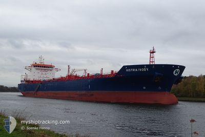
HISTRIA IVORY
Oil/Chemical Tanker
Current Trip
ITRAN
| Time Travelled | 9 h, 33 mins |
|---|---|
| Remaining Time | --- |
| Distance Travelled | 105.40 nm |
| Remaining Distance | --- |
| AVG Speed | 12.2 Knots |
| MAX Speed | 12.8 Knots |
| AVG Wind | 9.2 knots |
| MAX Wind | 18.9 knots |
| MIN Temp | 4.7°C / 40.46°F |
| MAX Temp | 8°C / 46.4°F |
| Draught | 8.3 m |
| Position Received | 2 d ago |
Current Position
| Longitude | --- |
|---|---|
| Latitude | --- |
| Status | Under way using engine |
| Speed | 11.5 Knots |
| Course | 189.5° |
| Area | Adriatic Sea |
| Station | T-AIS |
| Position Received | 2 d ago |
Info
Information
The current position of HISTRIA IVORY is in Adriatic Sea with coordinates 44.56897° / 12.72695° as reported on 2025-02-15 14:19 by AIS to our vessel tracker app. The vessel's current speed is 11.5 Knots
The vessel HISTRIA IVORY (IMO: 9356244, MMSI: 256286000) is a Oil/Chemical Tanker that was built in 2006 ( 19 years old ). It's sailing under the flag of [MT] Malta.
In this page you can find informations about the vessels current position, last detected port calls, and current voyage information. If the vessels is not in coverage by AIS you will find the latest position.
The current position of HISTRIA IVORY is detected by our AIS receivers and we are not responsible for the reliability of the data. The last position was recorded while the vessel was in Coverage by the Ais receivers of our vessel tracking app.
The current draught of HISTRIA IVORY as reported by AIS is 8.3 meters
Weather
| Temperature | 8°C / 46.4°F |
|---|---|
| Wind Speed | 6 knots |
| Direction | 355° N |
| Pressure | 1019.5 hPa |
| Humidity | 63.1 % |
| Cloud Coverage | 100 % |
Featured Company
Last Port Calls
| Port | Arrival | Departure | Time In Port |
|---|---|---|---|
| 2025-02-16 13:28 | 2025-02-17 11:46 | 22 h | |
| 2025-02-13 08:02 | 2025-02-15 09:37 | 2 d | |
| 2025-02-04 06:08 | 2025-02-09 03:16 | 4 d | |
| 2025-01-24 17:33 | 2025-01-25 16:41 | 23 h | |
| 2025-01-11 12:08 | 2025-01-12 19:51 | 1 d | |
| 2024-12-30 22:00 | 2025-01-01 02:28 | 1 d | |
| 2024-12-20 20:52 | 2024-12-22 06:44 | 1 d | |
| 2024-12-09 12:32 | 2024-12-11 17:59 | 2 d | |
| 2024-12-04 16:28 | 2024-12-05 16:49 | 1 d |
Most Visited Ports (Last year)
| Port | Arrivals | |
|---|---|---|
| 4 | ||
| 3 | ||
| 2 | ||
| 2 | ||
| 2 | ||
| 1 |
Last Trips
| Origin | Departure | Destination | Arrival | Distance | |
|---|---|---|---|---|---|
| 2025-02-15 09:37 | 2025-02-16 13:28 | 85.18 nm | |||
| 2025-02-09 03:16 | 2025-02-13 08:02 | 1056.66 nm | |||
| 2025-01-25 16:41 | 2025-02-04 06:08 | 1772.79 nm | |||
| 2025-01-12 19:51 | 2025-01-24 17:33 | 287.98 nm | |||
| 2025-01-01 02:28 | 2025-01-11 12:08 | 502.81 nm | |||
| 2024-12-22 06:44 | 2024-12-30 22:00 | 454.33 nm | |||
| 2024-12-11 17:59 | 2024-12-20 20:52 | 1686.17 nm | |||
| 2024-12-05 16:49 | 2024-12-09 12:32 | 985.33 nm | |||
| 2024-11-30 23:29 | 2024-12-04 16:28 | 291.88 nm |
Events
| Time | Event | Details | Position / Dest | Info |
|---|---|---|---|---|
| 2025-02-17 10:46 | PORT DEPARTURE |
|
44.49638 / 12.31657
ITRAN
|
Speed: 5.8 kn Course: 80° |
| 2025-02-17 09:52 | START Moving |
44.44392 / 12.24303
[IT] RAVENNA
|
Speed: 5 kn Course: 8° |
|
| 2025-02-16 13:43 | STOP Moving |
44.43883 / 12.24362
[IT] RAVENNA
|
Speed: Course: 342° |
|
| 2025-02-16 12:28 | PORT ARRIVAL |
|
44.49642 / 12.31183
[IT] RAVENNA
|
Speed: 9.2 kn Course: 259° |
| 2025-02-16 10:52 | START Moving | 12.93 nm, East of MARINA ROMEA |
44.48057 / 12.57130
ITRAN
|
Speed: 6.6 kn Course: 225° |
| 2025-02-15 15:45 | STOP Moving | 13.17 nm, East of MARINA ROMEA |
44.48435 / 12.57797
ITRAN
|
Speed: 0.3 kn Course: 40° |
| 2025-02-15 14:29 | Status Changed | Default Under way using engine |
44.53775 / 12.71573
ITRAN
|
Speed: 11.5 kn Course: 189.5° |
| 2025-02-15 14:19 | OUT of Coverage |
44.56897 / 12.72695
Adriatic Sea
ITRAN
|
Speed: 11.5 kn Course: 189.5° |
|
| 2025-02-15 11:08 | ETA Changed | 2025/02/15 17:00 2025/02/15 18:00 |
45.14953 / 12.61398
ITRAN
|
Speed: 11.9 kn Course: 127.4° |
| 2025-02-15 10:02 | ETA Changed | 2025/02/15 18:00 2025/02/15 14:00 |
45.28717 / 12.42095
ITRAN
|
Speed: 10.7 kn Course: 123.2° |