
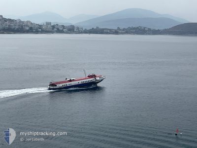
HARIKLIA
Passenger
Current Trip
SARANDA
| Time Travelled | 1 day |
|---|---|
| Remaining Time | --- |
| Distance Travelled | 3.65 nm |
| Remaining Distance | --- |
| AVG Speed | --- |
| MAX Speed | --- |
| AVG Wind | 11.1 knots |
| MAX Wind | 11.3 knots |
| MIN Temp | 12.9°C / 55.22°F |
| MAX Temp | 12.9°C / 55.22°F |
| Draught | 3.5 m |
| Position Received | 1 d ago |
Current Position
| Longitude | --- |
|---|---|
| Latitude | --- |
| Status | Under way using engine |
| Speed | 29.9 Knots |
| Course | 199.1° |
| Area | Adriatic Sea |
| Station | T-AIS |
| Position Received | 1 d ago |
Info
Information
The current position of HARIKLIA is in Adriatic Sea with coordinates 39.80602° / 19.98396° as reported on 2024-12-20 09:14 by AIS to our vessel tracker app. The vessel's current speed is 29.9 Knots
The vessel HARIKLIA (IMO: 793338500, MMSI: 201100184) is a Passenger It's sailing under the flag of [AL] Albania.
In this page you can find informations about the vessels current position, last detected port calls, and current voyage information. If the vessels is not in coverage by AIS you will find the latest position.
The current position of HARIKLIA is detected by our AIS receivers and we are not responsible for the reliability of the data. The last position was recorded while the vessel was in Coverage by the Ais receivers of our vessel tracking app.
The current draught of HARIKLIA as reported by AIS is 3.5 meters
Weather
| Temperature | 12.9°C / 55.22°F |
|---|---|
| Wind Speed | 11 knots |
| Direction | 133° SE |
| Pressure | 1011.8 hPa |
| Humidity | 80.4 % |
| Cloud Coverage | 100 % |
Featured Company
Last Port Calls
| Port | Arrival | Departure | Time In Port |
|---|---|---|---|
| 2024-12-20 08:10 | 2024-12-20 09:07 | 56 m | |
| 2024-12-19 07:40 | 2024-12-19 09:03 | 1 h | |
| 2024-12-18 07:35 | 2024-12-18 09:02 | 1 h | |
| 2024-12-17 07:37 | 2024-12-17 09:10 | 1 h | |
| 2024-12-16 07:38 | 2024-12-16 09:07 | 1 h | |
| 2024-12-15 07:34 | 2024-12-15 09:07 | 1 h | |
| 2024-12-14 07:35 | 2024-12-14 09:04 | 1 h | |
| 2024-12-13 07:38 | 2024-12-13 09:09 | 1 h | |
| 2024-12-12 15:40 | 2024-12-12 15:59 | 19 m | |
| 2024-12-12 07:43 | 2024-12-12 09:11 | 1 h |
Last Trips
| Origin | Departure | Destination | Arrival | Distance | |
|---|---|---|---|---|---|
| 2024-12-19 10:03 | 2024-12-20 09:10 | 29.45 nm | |||
| 2024-12-18 10:02 | 2024-12-19 08:40 | 22.97 nm | |||
| 2024-12-17 10:10 | 2024-12-18 08:35 | 9.31 nm | |||
| 2024-12-16 10:07 | 2024-12-17 08:37 | 12.82 nm | |||
| 2024-12-15 10:07 | 2024-12-16 08:38 | 29.81 nm | |||
| 2024-12-14 10:04 | 2024-12-15 08:34 | 9.06 nm | |||
| 2024-12-13 10:09 | 2024-12-14 08:35 | 8.91 nm | |||
| 2024-12-12 16:59 | 2024-12-13 08:38 | 8.76 nm | |||
| 2024-12-12 10:11 | 2024-12-12 16:40 | 26.78 nm | |||
| 2024-12-11 10:08 | 2024-12-12 08:43 | 8.39 nm |
Events
| Time | Event | Details | Position / Dest | Info |
|---|---|---|---|---|
| 2024-12-20 09:14 | OUT of Coverage |
39.80602 / 19.98396
Adriatic Sea
|
Speed: 29.9 kn Course: 199.1° |
|
| 2024-12-20 09:14 | Change Sea Area | Albanian part of the Adriatic Sea Greek part of the Adriatic Sea |
39.80602 / 19.98396
Adriatic Sea
|
Speed: 29.9 kn Course: 199.1° |
| 2024-12-20 09:07 | PORT DEPARTURE |
|
39.86319 / 20.00836
SARANDA
|
Speed: 27.4 kn Course: 190° |
| 2024-12-20 09:05 | START Moving |
39.86955 / 20.00640
[AL] SARANDE
|
Speed: 6.7 kn Course: 121.1° |
|
| 2024-12-20 08:59 | IN Coverage |
39.87002 / 20.00383
Adriatic Sea
[AL] SARANDE
|
Speed: 1 kn Course: 178.8° |
|
| 2024-12-20 08:10 | PORT ARRIVAL |
|
39.87066 / 20.00374
[AL] SARANDE
|
Speed: 6.2 kn Course: 116° |
| 2024-12-19 09:12 | OUT of Coverage |
39.79363 / 19.97466
Adriatic Sea
|
Speed: 29.5 kn Course: 190.1° |
|
| 2024-12-19 09:12 | Change Sea Area | Greek part of the Adriatic Sea Albanian part of the Adriatic Sea |
39.79363 / 19.97466
Adriatic Sea
|
Speed: 29.5 kn Course: 190.1° |
| 2024-12-19 09:10 | Change Sea Area | Albanian part of the Adriatic Sea Greek part of the Adriatic Sea |
39.80767 / 19.98080
Adriatic Sea
|
Speed: 29.7 kn Course: 201.1° |
| 2024-12-19 09:03 | PORT DEPARTURE |
|
39.86348 / 20.00687
SARANDA
|
Speed: 28.7 kn Course: 201.5° |