
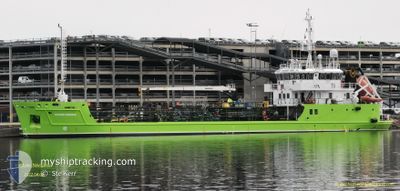
BIO NAVIGATOR
Oil Products Tanker
Current Trip
NOSKG
| Time Travelled | 2 days |
|---|---|
| Remaining Time | --- |
| Distance Travelled | 56.21 nm |
| Remaining Distance | --- |
| AVG Speed | 8.3 Knots |
| MAX Speed | 10 Knots |
| AVG Wind | 4.8 knots |
| MAX Wind | 14.2 knots |
| MIN Temp | 9.1°C / 48.38°F |
| MAX Temp | 13°C / 55.4°F |
| Draught | 4.2 m |
| Position Received | 2 m ago |
Current Position
| Longitude | 5.10635° |
|---|---|
| Latitude | 60.27004° |
| Status | Moored |
| Speed | |
| Course | 155° |
| Area | North Sea |
| Station | T-AIS |
| Position Received | 2 m ago |
Info
Information
The current position of BIO NAVIGATOR is in North Sea with coordinates 60.27004° / 5.10635° as reported on 2024-05-14 04:52 by AIS to our vessel tracker app. The vessel's current speed is 0 Knots
The vessel BIO NAVIGATOR (IMO: 9535400, MMSI: 259001980) is a Oil Products Tanker that was built in 2010 ( 14 years old ). It's sailing under the flag of [NO] Norway.
In this page you can find informations about the vessels current position, last detected port calls, and current voyage information. If the vessels is not in coverage by AIS you will find the latest position.
The current position of BIO NAVIGATOR is detected by our AIS receivers and we are not responsible for the reliability of the data. The last position was recorded while the vessel was in Coverage by the Ais receivers of our vessel tracking app.
The current draught of BIO NAVIGATOR as reported by AIS is 4.2 meters
Weather
| Temperature | 11.2°C / 52.16°F |
|---|---|
| Wind Speed | 12 knots |
| Direction | 122° ESE |
| Pressure | 1012.4 hPa |
| Humidity | 66.3 % |
| Cloud Coverage | 88 % |
Featured Company
Last Port Calls
| Port | Arrival | Departure | Time In Port |
|---|---|---|---|
| 2024-05-08 14:47 | 2024-05-11 08:10 | 2 d | |
| 2024-05-04 15:22 | 2024-05-05 08:11 | 16 h | |
| 2024-04-29 05:58 | 2024-05-04 08:09 | 5 d | |
| 2024-04-25 19:07 | 2024-04-25 20:54 | 1 h | |
| 2024-04-20 16:36 | 2024-04-24 07:13 | 3 d | |
| 2024-04-19 16:38 | 2024-04-20 08:07 | 15 h | |
| 2024-04-12 16:51 | 2024-04-19 08:25 | 6 d | |
| 2024-04-09 13:30 | 2024-04-12 05:16 | 2 d | |
| 2024-04-08 05:23 | 2024-04-08 15:26 | 10 h | |
| 2024-04-07 00:19 | 2024-04-07 15:20 | 15 h |
Last Trips
| Origin | Departure | Destination | Arrival | Distance | |
|---|---|---|---|---|---|
| 2024-05-05 08:11 | 2024-05-08 14:47 | 161.07 nm | |||
| 2024-05-04 08:09 | 2024-05-04 15:22 | 47.43 nm | |||
| 2024-04-25 20:54 | 2024-04-29 05:58 | 390.26 nm | |||
| 2024-04-24 07:13 | 2024-04-25 19:07 | 10.40 nm | |||
| 2024-04-20 08:07 | 2024-04-20 16:36 | 78.88 nm | |||
| 2024-04-19 08:25 | 2024-04-19 16:38 | 79.05 nm | |||
| 2024-04-12 05:16 | 2024-04-12 16:51 | 84.17 nm | |||
| 2024-04-08 15:26 | 2024-04-09 13:30 | 202.88 nm | |||
| 2024-04-07 15:20 | 2024-04-08 05:23 | 136.07 nm | |||
| 2024-03-23 08:34 | 2024-04-07 00:19 | 522.78 nm |
Events
| Time | Event | Details | Position / Dest | Info |
|---|---|---|---|---|
| 2024-05-13 13:16 | STOP Moving | 3.17 nm, North West of KLOKKARVIK |
60.27003 / 5.10638
NOSKG
|
Speed: Course: 154° |
| 2024-05-13 13:06 | START Moving | 3.04 nm, North West of KLOKKARVIK |
60.26885 / 5.11142
NOSKG
|
Speed: 3.2 kn Course: 327° |
| 2024-05-12 23:56 | Status Changed | Moored Default |
60.26802 / 5.10739
NOSKG
|
Speed: Course: 153° |
| 2024-05-12 23:50 | Status Changed | Default Moored |
60.26799 / 5.10737
NOSKG
|
Speed: Course: 153° |
| 2024-05-11 13:35 | Status Changed | Moored Under way using engine |
60.26803 / 5.10739
NOSKG
|
Speed: Course: 152° |
| 2024-05-11 12:56 | STOP Moving | 3.01 nm, North West of KLOKKARVIK |
60.26765 / 5.10848
NOSKG
|
Speed: 0.3 kn Course: 158° |
| 2024-05-11 08:56 | START Moving | 3.67 nm, South West of HOYLANDSBYGDA |
59.76005 / 5.68397
NOSKG
|
Speed: 6.6 kn Course: 286.5° |
| 2024-05-11 08:43 | STOP Moving | 3.56 nm, South West of HOYLANDSBYGDA |
59.75984 / 5.68850
NOSKG
|
Speed: Course: 268° |
| 2024-05-11 07:53 | START Moving | 3.54 nm, West of SKAVENIK |
59.71212 / 5.82556
NOSKG
|
Speed: 6.4 kn Course: 244.5° |
| 2024-05-11 07:42 | STOP Moving | 3.43 nm, West of SKAVENIK |
59.71325 / 5.82841
NOSKG
|
Speed: 0.2 kn Course: 228° |