
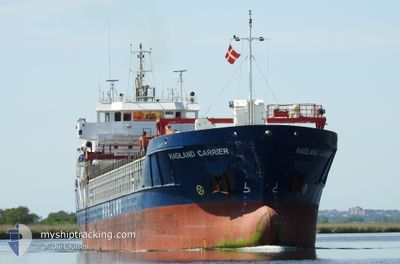
HAGLAND CARRIER
General Cargo
Current Trip
| Time Travelled | 2 days |
|---|---|
| Remaining Time | 7 h, 21 mins |
| Distance Travelled | 454.12 nm |
| Remaining Distance | 82.77 nm |
| AVG Speed | 9.7 Knots |
| MAX Speed | 11.7 Knots |
| AVG Wind | 15.3 knots |
| MAX Wind | 28.3 knots |
| MIN Temp | 4.1°C / 39.38°F |
| MAX Temp | 8.3°C / 46.94°F |
| Draught | 6.4 m |
| Position Received | 3 h, 28 m ago |
Current Position
| Longitude | --- |
|---|---|
| Latitude | --- |
| Status | Under way using engine |
| Speed | 11.5 Knots |
| Course | 108.8° |
| Area | Baltic Sea |
| Station | T-AIS |
| Position Received | 3 h, 28 m ago |
Info
Information
The current position of HAGLAND CARRIER is in Baltic Sea with coordinates 55.27827° / 12.72773° as reported on 2025-12-07 17:39 by AIS to our vessel tracker app. The vessel's current speed is 11.5 Knots and is heading at the port of KARLSHAMN. The estimated time of arrival as calculated by MyShipTracking vessel tracking app is 2025-12-08 05:29 LT
The vessel HAGLAND CARRIER (IMO: 9479931, MMSI: 257064430) is a General Cargo that was built in 2011 ( 14 years old ). It's sailing under the flag of [NO] Norway.
In this page you can find informations about the vessels current position, last detected port calls, and current voyage information. If the vessels is not in coverage by AIS you will find the latest position.
The current position of HAGLAND CARRIER is detected by our AIS receivers and we are not responsible for the reliability of the data. The last position was recorded while the vessel was in Coverage by the Ais receivers of our vessel tracking app.
The current draught of HAGLAND CARRIER as reported by AIS is 6.4 meters
Weather
| Temperature | 8.1°C / 46.58°F |
|---|---|
| Wind Speed | 13 knots |
| Direction | 184° S |
| Pressure | 1008.8 hPa |
| Humidity | 93.5 % |
| Cloud Coverage | 100 % |
Featured Company
Last Port Calls
| Port | Arrival | Departure | Time In Port |
|---|---|---|---|
| 2025-12-05 12:43 | 2025-12-05 17:35 | 4 h | |
| 2025-12-02 08:09 | 2025-12-03 23:23 | 1 d | |
| 2025-11-30 06:10 | 2025-11-30 21:33 | 15 h | |
| 2025-11-29 08:57 | 2025-11-29 15:12 | 6 h | |
| 2025-11-28 14:38 | 2025-11-29 02:01 | 11 h | |
| 2025-11-25 19:01 | 2025-11-26 06:41 | 11 h | |
| 2025-11-24 11:24 | 2025-11-25 08:42 | 21 h | |
| 2025-11-21 23:58 | 2025-11-22 21:30 | 21 h | |
| 2025-11-20 04:15 | 2025-11-20 10:11 | 5 h | |
| 2025-11-18 02:21 | 2025-11-18 17:50 | 15 h |
Most Visited Ports (Last year)
| Port | Arrivals | |
|---|---|---|
| 33 | ||
| 13 | ||
| 9 | ||
| 8 | ||
| 7 | ||
| 6 |
Last Trips
| Origin | Departure | Destination | Arrival | Distance | |
|---|---|---|---|---|---|
| 2025-12-03 23:23 | 2025-12-05 12:43 | 187.08 nm | |||
| 2025-11-30 21:33 | 2025-12-02 08:09 | 358.04 nm | |||
| 2025-11-29 15:12 | 2025-11-30 06:10 | 133.90 nm | |||
| 2025-11-29 02:01 | 2025-11-29 08:57 | 59.52 nm | |||
| 2025-11-26 06:41 | 2025-11-28 14:38 | 431.52 nm | |||
| 2025-11-25 08:42 | 2025-11-25 19:01 | 117.84 nm | |||
| 2025-11-22 21:30 | 2025-11-24 11:24 | 417.60 nm | |||
| 2025-11-20 10:11 | 2025-11-21 23:58 | 370.54 nm | |||
| 2025-11-18 17:50 | 2025-11-20 04:15 | 182.72 nm | |||
| 2025-11-17 03:38 | 2025-11-18 02:21 | 204.36 nm |
Events
| Time | Event | Details | Position / Dest | Info |
|---|---|---|---|---|
| 2025-12-07 17:45 | Status Changed | Default Under way using engine |
55.27227 / 12.75761
KARLSHAMN
|
Speed: 11.5 kn Course: 108.8° |
| 2025-12-07 17:39 | OUT of Coverage |
55.27827 / 12.72773
Baltic Sea
KARLSHAMN
|
Speed: 11.5 kn Course: 108.8° |
|
| 2025-12-07 17:25 | Change Sea Area | Swedish part of the Baltic Sea Danish part of the Baltic Sea |
55.29490 / 12.65692
Baltic Sea
KARLSHAMN
|
Speed: 11.1 kn Course: 114.2° |
| 2025-12-07 17:13 | Change Sea Area | Danish part of the Baltic Sea Danish part of the Kattegat |
55.32633 / 12.63509
Baltic Sea
KARLSHAMN
|
Speed: 10.6 kn Course: 183.1° |
| 2025-12-07 17:07 | Change Sea Area | Danish part of the Kattegat Swedish part of the Kattegat |
55.34512 / 12.63917
Kattegat
KARLSHAMN
|
Speed: 10.8 kn Course: 190.8° |
| 2025-12-07 16:25 | Change Sea Area | Swedish part of the Kattegat Danish part of the Kattegat |
55.46663 / 12.68337
Kattegat
KARLSHAMN
|
Speed: 10.7 kn Course: 191.5° |
| 2025-12-07 11:22 | Change Sea Area | Danish part of the Kattegat Swedish part of the Kattegat |
56.20286 / 12.38543
Kattegat
KARLSHAMN
|
Speed: 9.6 kn Course: 167.1° |
| 2025-12-07 10:47 | Status Changed | Under way using engine Default |
56.30118 / 12.34496
KARLSHAMN
|
Speed: 10.7 kn Course: 167° |
| 2025-12-07 10:47 | IN Coverage |
56.29539 / 12.34733
Kattegat
KARLSHAMN
|
Speed: 10.6 kn Course: 166.9° |
|
| 2025-12-07 06:46 | OUT of Coverage |
57.01519 / 11.99263
Kattegat
KARLSHAMN
|
Speed: 10.3 kn Course: 160.7° |