

GREEN BRAZIL
Cargo

Current Trip
| Time Travelled | 1 day |
|---|---|
| Remaining Time | 16 h, 4 mins |
| Distance Travelled | 637.87 nm |
| Remaining Distance | 249.19 nm |
| AVG Speed | 14.6 Knots |
| MAX Speed | 16.4 Knots |
| AVG Wind | 14 knots |
| MAX Wind | 17 knots |
| MIN Temp | 4.4°C / 39.92°F |
| MAX Temp | 12.9°C / 55.22°F |
| Draught | 7.2 m |
| Position Received | Now |
Current Position
| Longitude | --- |
|---|---|
| Latitude | --- |
| Status | Under way using engine |
| Speed | 15.5 Knots |
| Course | 209.1° |
| Area | North Sea |
| Station | T-AIS |
| Position Received | Now |
Information
The current position of GREEN BRAZIL is in North Sea with coordinates 56.20659° / 7.04528° as reported on 2025-03-29 08:18 by AIS to our vessel tracker app. The vessel's current speed is 15.5 Knots and is heading at the port of IJMUIDEN. The estimated time of arrival as calculated by MyShipTracking vessel tracking app is 2025-03-30 01:23 LT
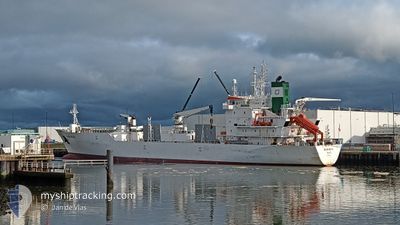
The vessel GREEN BRAZIL (IMO: 904579200, MMSI: 309681000) is a Cargo It's sailing under the flag of [BS] Bahamas.
In this page you can find informations about the vessels current position, last detected port calls, and current voyage information. If the vessels is not in coverage by AIS you will find the latest position.
The current position of GREEN BRAZIL is detected by our AIS receivers and we are not responsible for the reliability of the data. The last position was recorded while the vessel was in Coverage by the Ais receivers of our vessel tracking app.
The current draught of GREEN BRAZIL as reported by AIS is 7.2 meters
Weather
| Temperature | 6.2°C / 43.16°F |
|---|---|
| Wind Speed | 11 knots |
| Direction | 277° W |
| Pressure | 1014.5 hPa |
| Humidity | 88.9 % |
| Cloud Coverage | 20 % |


Featured Company
Last Port Calls
| Port | Arrival | Departure | Time In Port |
|---|---|---|---|
| 2025-03-25 08:32 | 2025-03-27 15:46 | 2 d | |
| 2025-03-19 05:13 | 2025-03-22 00:43 | 2 d | |
| 2025-03-06 18:09 | 2025-03-08 18:51 | 2 d | |
| 2025-02-05 20:07 | 2025-02-08 00:43 | 2 d | |
| 2025-02-04 01:47 | 2025-02-05 16:27 | 1 d | |
| 2025-02-03 20:43 | 2025-02-03 22:19 | 1 h | |
| 2025-01-22 09:17 | 2025-01-23 16:35 | 1 d | |
| 2025-01-19 10:11 | 2025-01-21 07:14 | 1 d |
Most Visited Ports (Last year)
| Port | Arrivals | |
|---|---|---|
| 4 | ||
| 2 | ||
| 2 | ||
| 2 | ||
| 1 | ||
| 1 |
Last Trips
| Origin | Departure | Destination | Arrival | Distance | |
|---|---|---|---|---|---|
| 2025-03-22 00:43 | 2025-03-25 08:32 | 1027.86 nm | |||
| 2025-03-08 18:51 | 2025-03-19 05:13 | 3330.30 nm | |||
| 2025-02-08 00:43 | 2025-03-06 18:09 | 7983.87 nm | |||
| 2025-02-05 16:27 | 2025-02-05 20:07 | 50.74 nm | |||
| 2025-02-03 22:19 | 2025-02-04 01:47 | 49.66 nm | |||
| 2025-01-23 16:35 | 2025-02-03 20:43 | 3608.89 nm | |||
| 2025-01-21 07:14 | 2025-01-22 09:17 | 351.85 nm | |||
| 2024-12-23 21:27 | 2025-01-19 10:11 | 8443.39 nm |
Events
| Time | Event | Details | Position / Dest | Info |
|---|---|---|---|---|
| 2025-03-29 03:04 | Change Sea Area | Danish part of the North Sea Danish part of the Skaggerak |
57.33575 / 8.20013
North Sea
NL IJM
|
Speed: 14.6 kn Course: 222.6° |
| 2025-03-28 20:20 | Change Sea Area | Danish part of the Skaggerak Danish part of the Kattegat |
57.81608 / 10.95659
Skaggerak
NL IJM
|
Speed: 15.3 kn Course: 321.5° |
| 2025-03-28 19:22 | Change Sea Area | Danish part of the Kattegat Swedish part of the Kattegat |
57.61770 / 11.23700
Kattegat
NL IJM
|
Speed: 15.6 kn Course: 319° |
| 2025-03-28 12:50 | Change Sea Area | Swedish part of the Kattegat Danish part of the Kattegat |
56.12293 / 12.53765
Kattegat
NL IJM
|
Speed: 15.1 kn Course: 316.4° |
| 2025-03-28 12:46 | Change Sea Area | Danish part of the Kattegat Swedish part of the Kattegat |
56.11081 / 12.55869
Kattegat
NL IJM
|
Speed: 15.2 kn Course: 314.6° |
| 2025-03-28 11:29 | Change Sea Area | Swedish part of the Kattegat Danish part of the Kattegat |
55.82384 / 12.71965
Kattegat
NL IJM
|
Speed: 15 kn Course: 8.8° |
| 2025-03-28 09:50 | Change Sea Area | Danish part of the Kattegat Swedish part of the Kattegat |
55.49105 / 12.70678
Kattegat
NL IJM
|
Speed: 14.4 kn Course: 12.2° |
| 2025-03-28 09:14 | Change Sea Area | Swedish part of the Kattegat Swedish part of the Baltic Sea |
55.34343 / 12.67577
Kattegat
NL IJM
|
Speed: 15.7 kn Course: 0.6° |
| 2025-03-28 04:23 | Change Sea Area | Swedish part of the Baltic Sea Danish part of the Kattegat |
55.43476 / 14.62911
Baltic Sea
NL IJM
|
Speed: 15.3 kn Course: 268.8° |
| 2025-03-28 01:19 | Change Sea Area | Danish part of the Kattegat Swedish part of the Baltic Sea |
55.46960 / 15.98790
Kattegat
NL IJM
|
Speed: 15 kn Course: 267.8° |