

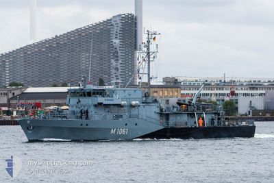
GERMAN WARSHIP M1061
Military ops

Current Trip
| Trip Time | 3 days |
|---|---|
| Trip Distance | 352.46 nm |
| AVG Speed | 11.1 Knots |
| MAX Speed | 11.1 Knots |
| Draught | 0 m |
| AVG Wind | 10.6 knots |
| MAX Wind | 16 knots |
| MIN Temp | 4.1°C / 39.38°F |
| MAX Temp | 11.6°C / 52.88°F |
| Position Received | 19 m ago |
Current Position
| Longitude | --- |
|---|---|
| Latitude | --- |
| Status | Moored |
| Speed | |
| Course | --- |
| Area | Baltic Sea |
| Station | T-AIS |
| Position Received | 19 m ago |
Information
The current position of GERMAN WARSHIP M1061 is in Baltic Sea with coordinates 53.42956° / 14.56747° as reported on 2025-03-29 06:32 by AIS to our vessel tracker app. The vessel's current speed is 0 Knots and is currently inside the port of SZCZECIN.
The vessel GERMAN WARSHIP M1061 (MMSI: 211211160) is a Military ops It's sailing under the flag of [DE] Germany.
In this page you can find informations about the vessels current position, last detected port calls, and current voyage information. If the vessels is not in coverage by AIS you will find the latest position.
The current position of GERMAN WARSHIP M1061 is detected by our AIS receivers and we are not responsible for the reliability of the data. The last position was recorded while the vessel was in Coverage by the Ais receivers of our vessel tracking app.
Weather
| Temperature | 7.1°C / 44.78°F |
|---|---|
| Wind Speed | 2 knots |
| Direction | 90° E |
| Pressure | 1010.7 hPa |
| Humidity | 78.3 % |
| Cloud Coverage | 97 % |


Featured Company
Last Port Calls
| Port | Arrival | Departure | Time In Port |
|---|---|---|---|
| 2025-03-28 09:29 | |||
| 2025-03-24 11:05 | 2025-03-24 15:46 | 4 h | |
| 2025-03-11 13:09 | 2025-03-24 09:11 | 12 d | |
| 2025-01-30 12:04 | 2025-03-11 07:43 | ||
| 2025-01-16 10:54 | 2025-01-27 10:22 | 10 d | |
| 2025-01-14 15:02 | 2025-01-15 07:32 | 16 h | |
| 2025-01-14 10:54 |
Most Visited Ports (Last year)
| Port | Arrivals | |
|---|---|---|
| 14 | ||
| 7 | ||
| 2 | ||
| 1 | ||
| 1 | ||
| 1 |
Last Trips
| Origin | Departure | Destination | Arrival | Distance | |
|---|---|---|---|---|---|
| 2025-03-24 16:46 | 2025-03-28 10:29 | 352.46 nm | |||
| 2025-03-24 10:11 | 2025-03-24 12:05 | 21.37 nm | |||
| 2025-03-11 08:43 | 2025-03-11 14:09 | 49.43 nm | |||
| 2025-01-27 11:22 | 2025-01-30 13:04 | 399.69 nm | |||
| 2025-01-15 08:32 | 2025-01-16 11:54 | 197.37 nm | |||
| 2025-01-14 11:54 | 2025-01-14 16:02 | 15.25 nm |
Events
| Time | Event | Details | Position / Dest | Info |
|---|---|---|---|---|
| 2025-03-28 20:53 | IN Coverage |
53.42956 / 14.56745
Baltic Sea
[PL] SZCZECIN
|
Speed: Course: 221.2° |
|
| 2025-03-28 18:32 | OUT of Coverage |
53.42957 / 14.56747
Baltic Sea
[PL] SZCZECIN
|
Speed: Course: 121.4° |
|
| 2025-03-28 09:38 | Status Changed | Moored Under way using engine |
53.42955 / 14.56746
[PL] SZCZECIN
|
Speed: Course: 218° |
| 2025-03-28 09:29 | STOP Moving |
53.42947 / 14.56760
[PL] SZCZECIN
|
Speed: 0.2 kn Course: 223° |
|
| 2025-03-28 09:29 | PORT ARRIVAL |
|
53.42947 / 14.56760
[PL] SZCZECIN
|
Speed: 0.9 kn Course: 223° |
| 2025-03-28 08:32 | IN Coverage |
53.53570 / 14.63085
Baltic Sea
|
Speed: 11.9 kn Course: 169.8° |
|
| 2025-03-28 00:34 | OUT of Coverage |
54.50661 / 14.39785
Baltic Sea
|
Speed: 12 kn Course: 268.6° |
|
| 2025-03-28 00:31 | Detected in Sea | German part of the Baltic Sea |
54.50685 / 14.41450
Baltic Sea
|
Speed: 12 kn Course: 268.4° |
| 2025-03-27 23:25 | Detected in Sea | Polish part of the Baltic Sea |
54.57500 / 14.72883
Baltic Sea
|
Speed: 11.8 kn Course: 210.2° |
| 2025-03-27 21:02 | START Moving | 4.89 nm, South of NEKSO |
54.98330 / 15.13049
|
Speed: 4.1 kn Course: 187° |