
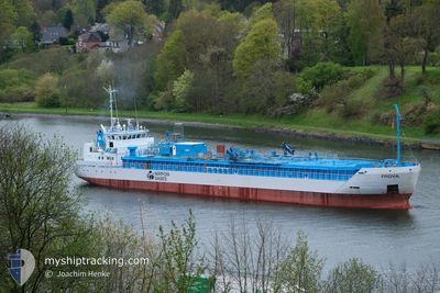
FROYA
Co2 Tanker
Current Trip
| Time Travelled | 1 day |
|---|---|
| Remaining Time | --- |
| Distance Travelled | 341.56 nm |
| Remaining Distance | --- |
| AVG Speed | 12.3 Knots |
| MAX Speed | 15.1 Knots |
| AVG Wind | 12.9 knots |
| MAX Wind | 22.8 knots |
| MIN Temp | 9.1°C / 48.38°F |
| MAX Temp | 11.5°C / 52.7°F |
| Draught | 3.7 m |
| Position Received | 2 m ago |
Current Position
| Longitude | 9.42586° |
|---|---|
| Latitude | 58.24575° |
| Status | Under way using engine |
| Speed | 8.2 Knots |
| Course | 25.5° |
| Area | Skaggerak |
| Station | T-AIS |
| Position Received | 2 m ago |
Info
Information
The current position of FROYA is in Skaggerak with coordinates 58.24575° / 9.42586° as reported on 2024-04-29 00:21 by AIS to our vessel tracker app. The vessel's current speed is 8.2 Knots and is heading at the port of PORSGRUNN. The estimated time of arrival as calculated by MyShipTracking vessel tracking app is 2024-04-29 08:00 LT
The vessel FROYA (IMO: 9345350, MMSI: 257081000) is a Co2 Tanker that was built in 2005 ( 19 years old ). It's sailing under the flag of [NO] Norway.
In this page you can find informations about the vessels current position, last detected port calls, and current voyage information. If the vessels is not in coverage by AIS you will find the latest position.
The current position of FROYA is detected by our AIS receivers and we are not responsible for the reliability of the data. The last position was recorded while the vessel was in Coverage by the Ais receivers of our vessel tracking app.
The current draught of FROYA as reported by AIS is 3.7 meters
Weather
| Temperature | 9.3°C / 48.74°F |
|---|---|
| Wind Speed | 15 knots |
| Direction | 177° S |
| Pressure | 1010.1 hPa |
| Humidity | 94.9 % |
| Cloud Coverage | 100 % |
Featured Company
Last Port Calls
| Port | Arrival | Departure | Time In Port |
|---|---|---|---|
| 2024-04-27 10:33 | 2024-04-27 19:07 | 8 h | |
| 2024-04-26 04:02 | 2024-04-26 13:29 | 9 h | |
| 2024-04-23 18:48 | 2024-04-25 01:02 | 1 d | |
| 2024-04-20 16:11 | 2024-04-23 10:30 | 2 d | |
| 2024-04-18 16:52 | 2024-04-19 02:04 | 9 h | |
| 2024-04-15 17:47 | 2024-04-16 07:01 | 13 h | |
| 2024-04-13 22:36 | 2024-04-14 18:11 | 19 h | |
| 2024-04-12 02:17 | 2024-04-12 12:13 | 9 h | |
| 2024-04-11 12:47 | 2024-04-11 13:36 | 48 m | |
| 2024-04-10 19:25 | 2024-04-11 04:55 | 9 h |
Last Trips
| Origin | Departure | Destination | Arrival | Distance | |
|---|---|---|---|---|---|
| 2024-04-26 15:29 | 2024-04-27 12:33 | 172.08 nm | |||
| 2024-04-25 03:02 | 2024-04-26 06:02 | 250.34 nm | |||
| 2024-04-23 12:30 | 2024-04-23 20:48 | 97.03 nm | |||
| 2024-04-19 04:04 | 2024-04-20 18:11 | 338.02 nm | |||
| 2024-04-16 09:01 | 2024-04-18 18:52 | 175.64 nm | |||
| 2024-04-14 20:11 | 2024-04-15 19:47 | 249.69 nm | |||
| 2024-04-12 14:13 | 2024-04-14 00:36 | 405.72 nm | |||
| 2024-04-11 15:36 | 2024-04-12 04:17 | 87.58 nm | |||
| 2024-04-11 06:55 | 2024-04-11 14:47 | 84.76 nm | |||
| 2024-04-09 21:44 | 2024-04-10 21:25 | 248.99 nm |
Events
| Time | Event | Details | Position / Dest | Info |
|---|---|---|---|---|
| 2024-04-28 20:17 | Change Sea Area | Norwegian part of the Skaggerak Danish part of the Skaggerak |
57.68427 / 8.80015
Skaggerak
NOHRY
|
Speed: 11.2 kn Course: 34.7° |
| 2024-04-28 17:41 | Detected in Sea | Danish part of the Skaggerak |
57.29979 / 8.29839
Skaggerak
NOHRY
|
Speed: 11.7 kn Course: 25.9° |
| 2024-04-28 10:03 | ETA Changed | 2024/04/29 08:00 2024/04/29 10:00 |
55.85370 / 7.46508
NOHRY
|
Speed: 12 kn Course: 11.4° |
| 2024-04-28 06:34 | Detected in Sea | Danish part of the North Sea |
55.16680 / 7.56423
North Sea
NOHRY
|
Speed: 12.4 kn Course: 344.5° |
| 2024-04-27 19:07 | PORT DEPARTURE |
|
53.54548 / 9.85629
NOHRY
|
Speed: 12.2 kn Course: 287° |
| 2024-04-27 18:51 | Draught Changed | 3.7 3 |
53.52992 / 9.93937
[DE] HAMBURG
|
Speed: 12 kn Course: 357° |
| 2024-04-27 18:51 | ETA Changed | 2024/04/29 10:00 |
53.52992 / 9.93937
[DE] HAMBURG
|
Speed: 12 kn Course: 357° |
| 2024-04-27 18:45 | Draught Changed | 3 3.7 |
53.51359 / 9.94627
[DE] HAMBURG
|
Speed: 8.4 kn Course: 321° |
| 2024-04-27 18:41 | START Moving |
53.50943 / 9.95301
[DE] HAMBURG
|
Speed: 4.7 kn Course: 287° |
|
| 2024-04-27 18:21 | Status Changed | Under way using engine Moored |
53.50979 / 9.95621
[DE] HAMBURG
|
Speed: Course: 238° |