
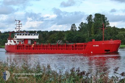
FRI W
General Cargo
Current Trip
| Time Travelled | 3 days |
|---|---|
| Remaining Time | --- |
| Distance Travelled | 488.29 nm |
| Remaining Distance | --- |
| AVG Speed | 7.5 Knots |
| MAX Speed | 8.9 Knots |
| AVG Wind | 6.8 knots |
| MAX Wind | 13.8 knots |
| MIN Temp | 13.6°C / 56.48°F |
| MAX Temp | 22.4°C / 72.32°F |
| Draught | 3.2 m |
| Position Received | 1 d ago |
Current Position
| Longitude | 6.75953° |
|---|---|
| Latitude | 37.51220° |
| Status | Under way using engine |
| Speed | 8.3 Knots |
| Course | 251.8° |
| Area | Mediterranean Sea - Western Basin |
| Station | T-AIS |
| Position Received | 1 d ago |
Info
Information
The current position of FRI W is in Mediterranean Sea - Western Basin with coordinates 37.51220° / 6.75953° as reported on 2024-06-02 00:52 by AIS to our vessel tracker app. The vessel's current speed is 8.3 Knots and is heading at the port of DJEN DJEN. The estimated time of arrival as calculated by MyShipTracking vessel tracking app is 2024-06-02 18:00 LT
The vessel FRI W (IMO: 8915627, MMSI: 314675000) is a General Cargo that was built in 1990 ( 34 years old ). It's sailing under the flag of [BB] Barbados.
In this page you can find informations about the vessels current position, last detected port calls, and current voyage information. If the vessels is not in coverage by AIS you will find the latest position.
The current position of FRI W is detected by our AIS receivers and we are not responsible for the reliability of the data. The last position was recorded while the vessel was in Coverage by the Ais receivers of our vessel tracking app.
The current draught of FRI W as reported by AIS is 3.2 meters
Weather
| Temperature | 19.2°C / 66.56°F |
|---|---|
| Wind Speed | 7 knots |
| Direction | 33° NNE |
| Pressure | 1016 hPa |
| Humidity | 66.9 % |
| Cloud Coverage | 57 % |
Featured Company
Last Port Calls
| Port | Arrival | Departure | Time In Port |
|---|---|---|---|
| 2024-05-29 06:42 | 2024-05-30 19:46 | 1 d | |
| 2024-05-20 11:02 | 2024-05-24 08:31 | 3 d | |
| 2024-05-18 05:57 | 2024-05-19 09:36 | 1 d | |
| 2024-05-15 19:10 | 2024-05-17 09:55 | 1 d | |
| 2024-04-28 16:27 | |||
| 2024-04-13 12:09 | 2024-04-14 15:56 | 1 d | |
| 2024-04-05 09:48 | 2024-04-09 11:18 | 4 d | |
| 2024-04-01 05:22 | 2024-04-03 10:40 | 2 d |
Last Trips
| Origin | Departure | Destination | Arrival | Distance | |
|---|---|---|---|---|---|
| 2024-05-24 10:31 | 2024-05-29 08:42 | 784.56 nm | |||
| 2024-05-19 11:36 | 2024-05-20 13:02 | 197.45 nm | |||
| 2024-05-17 11:55 | 2024-05-18 07:57 | 110.67 nm | |||
| 2024-04-28 19:27 | 2024-05-15 21:10 | 1731.11 nm | |||
| 2024-04-09 14:18 | 2024-04-13 15:09 | 549.13 nm | |||
| 2024-04-03 13:40 | 2024-04-05 12:48 | 185.29 nm | |||
| 2024-03-28 13:56 | 2024-04-01 08:22 | 534.45 nm |
Events
| Time | Event | Details | Position / Dest | Info |
|---|---|---|---|---|
| 2024-06-02 09:10 | STOP Moving | 2.61 nm, East of JIJEL |
36.82905 / 5.83314
DZ DJE
|
Speed: 0.3 kn Course: 83° |
| 2024-06-02 00:58 | Status Changed | Default Under way using engine |
37.50890 / 6.73969
DZ DJE
|
Speed: 8.3 kn Course: 251.8° |
| 2024-06-02 00:52 | OUT of Coverage |
37.51220 / 6.75953
Mediterranean Sea - Western Basin
DZ DJE
|
Speed: 8.3 kn Course: 251.8° |
|
| 2024-06-02 00:47 | Status Changed | Under way using engine Default |
37.51452 / 6.77285
DZ DJE
|
Speed: 8.5 kn Course: 243° |
| 2024-06-02 00:40 | IN Coverage |
37.51452 / 6.77285
Mediterranean Sea - Western Basin
DZ DJE
|
Speed: 8.2 kn Course: 256.9° |
|
| 2024-06-01 21:13 | Status Changed | Default Under way using engine |
37.63882 / 7.38208
DZ DJE
|
Speed: 8.1 kn Course: 256.1° |
| 2024-06-01 20:55 | Detected in Sea | Algerian part of the Mediterranean Sea - Western Basin |
37.64847 / 7.45557
Mediterranean Sea - Western Basin
DZ DJE
|
Speed: 8.1 kn Course: 256.1° |
| 2024-06-01 20:55 | Status Changed | Under way using engine Default |
37.64847 / 7.45557
DZ DJE
|
Speed: 8 kn Course: 260° |
| 2024-06-01 20:55 | IN Coverage |
37.64847 / 7.45557
Mediterranean Sea - Western Basin
DZ DJE
|
Speed: 8.1 kn Course: 256.1° |
|
| 2024-06-01 20:55 | OUT of Coverage |
37.64847 / 7.45557
Mediterranean Sea - Western Basin
DZ DJE
|
Speed: 8.1 kn Course: 256.1° |