

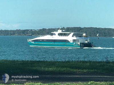
FREEDOM SOVEREIGN
Passenger

Current Trip
PORT OF AIRLIE
| Time Travelled | 7 days |
|---|---|
| Remaining Time | --- |
| Distance Travelled | 14.68 nm |
| Remaining Distance | --- |
| AVG Speed | 18.4 Knots |
| MAX Speed | 20.3 Knots |
| AVG Wind | 10.2 knots |
| MAX Wind | 11 knots |
| MIN Temp | 25.5°C / 77.9°F |
| MAX Temp | 26.4°C / 79.52°F |
| Draught | 1.8 m |
| Position Received | 15 d ago |
Current Position
| Longitude | --- |
|---|---|
| Latitude | --- |
| Status | Under way using engine |
| Speed | |
| Course | --- |
| Area | Coral Sea |
| Station | T-AIS |
| Position Received | 15 d ago |
Information
The current position of FREEDOM SOVEREIGN is in Coral Sea with coordinates -20.27272° / 148.72576° as reported on 2025-03-12 06:33 by AIS to our vessel tracker app. The vessel's current speed is 0 Knots
The vessel FREEDOM SOVEREIGN (MMSI: 503581800) is a Passenger It's sailing under the flag of [AU] Australia.
In this page you can find informations about the vessels current position, last detected port calls, and current voyage information. If the vessels is not in coverage by AIS you will find the latest position.
The current position of FREEDOM SOVEREIGN is detected by our AIS receivers and we are not responsible for the reliability of the data. The last position was recorded while the vessel was in Coverage by the Ais receivers of our vessel tracking app.
The current draught of FREEDOM SOVEREIGN as reported by AIS is 1.8 meters
Weather
| Temperature | 25.5°C / 77.9°F |
|---|---|
| Wind Speed | 10 knots |
| Direction | 144° SE |
| Pressure | 1014.1 hPa |
| Humidity | 79.4 % |
| Cloud Coverage | 100 % |


Featured Company
Last Port Calls
| Port | Arrival | Departure | Time In Port |
|---|---|---|---|
| 2025-03-20 17:20 | 2025-03-20 17:29 | 8 m | |
| 2025-03-20 15:49 | 2025-03-20 16:10 | 21 m | |
| 2025-03-20 14:17 | 2025-03-20 14:45 | 28 m | |
| 2025-03-20 13:32 | 2025-03-20 13:45 | 12 m | |
| 2025-03-20 11:16 | 2025-03-20 12:53 | 1 h | |
| 2025-03-20 09:49 | 2025-03-20 10:08 | 19 m | |
| 2025-03-20 08:04 | 2025-03-20 08:32 | 27 m | |
| 2025-03-19 18:32 | 2025-03-20 07:11 | 12 h | |
| 2025-03-19 17:17 | 2025-03-19 17:33 | 16 m | |
| 2025-03-19 15:49 | 2025-03-19 16:12 | 23 m |
Most Visited Ports (Last year)
| Port | Arrivals | |
|---|---|---|
| 371 | ||
| 123 | ||
| 45 | ||
| 5 | ||
| 1 |
Last Trips
| Origin | Departure | Destination | Arrival | Distance | |
|---|---|---|---|---|---|
| 2025-03-20 16:10 | 2025-03-20 17:20 | 16.72 nm | |||
| 2025-03-20 14:45 | 2025-03-20 15:49 | 15.87 nm | |||
| 2025-03-20 13:45 | 2025-03-20 14:17 | 9.12 nm | |||
| 2025-03-20 12:53 | 2025-03-20 13:32 | 8.48 nm | |||
| 2025-03-20 10:08 | 2025-03-20 11:16 | 16.66 nm | |||
| 2025-03-20 08:32 | 2025-03-20 09:49 | 15.78 nm | |||
| 2025-03-20 07:11 | 2025-03-20 08:04 | 12.04 nm | |||
| 2025-03-19 17:33 | 2025-03-19 18:32 | 15.66 nm | |||
| 2025-03-19 16:12 | 2025-03-19 17:17 | 16.66 nm | |||
| 2025-03-19 14:41 | 2025-03-19 15:49 | 16.84 nm |
Events
| Time | Event | Details | Position / Dest | Info |
|---|---|---|---|---|
| 2025-03-20 08:09 | START Moving | 3.26 nm, North East of SHUTE HARBOUR |
-20.24570 / 148.81055
PORT OF AIRLIE
|
Speed: 19.6 kn Course: 296° |
| 2025-03-20 08:01 | STOP Moving | 2.94 nm, North East of SHUTE HARBOUR |
-20.25392 / 148.81467
PORT OF AIRLIE
|
Speed: Course: -1° |
| 2025-03-20 07:29 | PORT DEPARTURE |
|
-20.33718 / 148.93384
PORT OF AIRLIE
|
Speed: 6.5 kn Course: -1° |
| 2025-03-20 07:25 | START Moving |
-20.34682 / 148.94961
[AU] HAMILTON ISLAND
|
Speed: 6.5 kn Course: -1° |
|
| 2025-03-20 07:21 | STOP Moving |
-20.34652 / 148.95161
[AU] HAMILTON ISLAND
|
Speed: Course: -1° |
|
| 2025-03-20 07:20 | PORT ARRIVAL |
|
-20.34652 / 148.95161
[AU] HAMILTON ISLAND
|
Speed: 9.4 kn Course: 80° |
| 2025-03-20 06:45 | START Moving | 2.68 nm, North East of SHUTE HARBOUR |
-20.26292 / 148.81917
PORT OF AIRLIE
|
Speed: 17 kn Course: 165° |
| 2025-03-20 06:37 | STOP Moving | 2.94 nm, North East of SHUTE HARBOUR |
-20.25388 / 148.81459
PORT OF AIRLIE
|
Speed: Course: -1° |
| 2025-03-20 06:10 | START Moving | 0.56 nm, East of AIRLIE |
-20.26433 / 148.72761
PORT OF AIRLIE
|
Speed: 8.7 kn Course: -1° |
| 2025-03-20 06:10 | PORT DEPARTURE |
|
-20.26433 / 148.72761
PORT OF AIRLIE
|
Speed: 3.6 kn Course: -1° |