
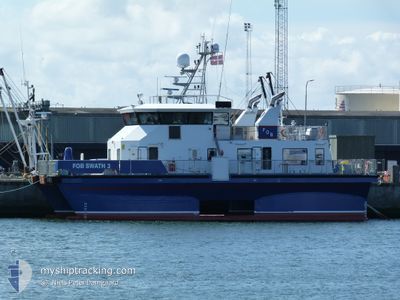
FOB SWATH 3
Crew Boat
Current Trip
| Time Travelled | 1 day |
|---|---|
| Remaining Time | --- |
| Distance Travelled | 104.55 nm |
| Remaining Distance | --- |
| AVG Speed | 10.4 Knots |
| MAX Speed | 14.1 Knots |
| AVG Wind | 14.8 knots |
| MAX Wind | 17.8 knots |
| MIN Temp | 3.1°C / 37.58°F |
| MAX Temp | 4.3°C / 39.74°F |
| Draught | 2.4 m |
| Position Received | 1 d ago |
Current Position
| Longitude | --- |
|---|---|
| Latitude | --- |
| Status | Under way using engine |
| Speed | 12.9 Knots |
| Course | 307.3° |
| Area | North Sea |
| Station | T-AIS |
| Position Received | 1 d ago |
Info
Information
The current position of FOB SWATH 3 is in North Sea with coordinates 53.53822° / 6.72642° as reported on 2025-03-14 05:26 by AIS to our vessel tracker app. The vessel's current speed is 12.9 Knots
The vessel FOB SWATH 3 (IMO: 9672935, MMSI: 219460000) is a Crew Boat that was built in 2013 ( 12 years old ). It's sailing under the flag of [DK] Denmark.
In this page you can find informations about the vessels current position, last detected port calls, and current voyage information. If the vessels is not in coverage by AIS you will find the latest position.
The current position of FOB SWATH 3 is detected by our AIS receivers and we are not responsible for the reliability of the data. The last position was recorded while the vessel was in Coverage by the Ais receivers of our vessel tracking app.
The current draught of FOB SWATH 3 as reported by AIS is 2.4 meters
Weather
| Temperature | 3.5°C / 38.3°F |
|---|---|
| Wind Speed | 10 knots |
| Direction | 59° ENE |
| Pressure | 1023.1 hPa |
| Humidity | 66.9 % |
| Cloud Coverage | 6 % |
Featured Company
Last Port Calls
| Port | Arrival | Departure | Time In Port |
|---|---|---|---|
| 2025-03-13 03:52 | 2025-03-14 05:58 | 1 d | |
| 2025-03-11 02:53 | 2025-03-12 08:47 | 1 d | |
| 2025-03-05 03:43 | 2025-03-06 03:45 | 1 d | |
| 2025-02-23 22:43 | 2025-02-24 18:43 | 20 h | |
| 2025-02-20 07:44 | 2025-02-21 05:02 | 21 h | |
| 2025-02-09 09:31 | 2025-02-20 05:06 | 10 d | |
| 2025-01-16 07:23 | 2025-02-08 14:54 | 23 d | |
| 2025-01-13 20:44 | 2025-01-14 17:40 | 20 h | |
| 2025-01-06 06:20 | 2025-01-09 22:41 | 3 d | |
| 2025-01-05 10:39 | 2025-01-05 10:51 | 11 m |
Last Trips
| Origin | Departure | Destination | Arrival | Distance | |
|---|---|---|---|---|---|
| 2025-03-12 08:47 | 2025-03-13 03:52 | 106.80 nm | |||
| 2025-03-06 03:45 | 2025-03-11 02:53 | 336.57 nm | |||
| 2025-02-24 18:43 | 2025-03-05 03:43 | 613.51 nm | |||
| 2025-02-21 05:02 | 2025-02-23 22:43 | 210.26 nm | |||
| 2025-02-20 05:06 | 2025-02-20 07:44 | 25.47 nm | |||
| 2025-02-08 14:54 | 2025-02-09 09:31 | 204.53 nm | |||
| 2025-01-14 17:40 | 2025-01-16 07:23 | 415.60 nm | |||
| 2025-01-09 22:41 | 2025-01-13 20:44 | 289.74 nm | |||
| 2025-01-05 10:51 | 2025-01-06 06:20 | 96.18 nm | |||
| 2025-01-03 18:34 | 2025-01-05 10:39 | 125.32 nm |
Events
| Time | Event | Details | Position / Dest | Info |
|---|---|---|---|---|
| 2025-03-15 07:13 | STOP Moving |
54.02885 / 6.13328
BORKUM RIF3
|
Speed: 0.3 kn Course: 276° |
|
| 2025-03-15 06:57 | START Moving |
54.02674 / 6.13589
BORKUM RIF3
|
Speed: 11.1 kn Course: 346° |
|
| 2025-03-15 06:52 | STOP Moving |
54.01962 / 6.13736
BORKUM RIF3
|
Speed: 0.2 kn Course: 278° |
|
| 2025-03-15 06:13 | START Moving |
54.02175 / 6.11107
BORKUM RIF3
|
Speed: 5.8 kn Course: 46° |
|
| 2025-03-15 05:22 | STOP Moving |
54.02868 / 6.12463
BORKUM RIF3
|
Speed: 0.2 kn Course: 59° |
|
| 2025-03-15 04:39 | START Moving |
54.03592 / 6.28984
BORKUM RIF3
|
Speed: 11.3 kn Course: 5° |
|
| 2025-03-15 02:36 | STOP Moving |
54.02828 / 6.28937
BORKUM RIF3
|
Speed: 0.3 kn Course: 279° |
|
| 2025-03-15 01:20 | START Moving |
53.97527 / 6.14012
BORKUM RIF3
|
Speed: 7.5 kn Course: 352° |
|
| 2025-03-14 20:58 | STOP Moving |
54.01967 / 6.16785
BORKUM RIF3
|
Speed: 0.3 kn Course: 278° |
|
| 2025-03-14 20:29 | START Moving |
54.05837 / 6.25547
BORKUM RIF3
|
Speed: 8.7 kn Course: 78° |