

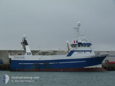
FISHER BANK
Trawler

Current Trip
PETERHEAD
| Time Travelled | 8 days |
|---|---|
| Remaining Time | --- |
| Distance Travelled | 308.78 nm |
| Remaining Distance | --- |
| AVG Speed | 11.2 Knots |
| MAX Speed | 12.1 Knots |
| AVG Wind | 17 knots |
| MAX Wind | 20 knots |
| MIN Temp | 4.9°C / 40.82°F |
| MAX Temp | 6.6°C / 43.88°F |
| Draught | 0 m |
| Position Received | 2 d ago |
Current Position
| Longitude | --- |
|---|---|
| Latitude | --- |
| Status | Engaged in Fishing |
| Speed | 3 Knots |
| Course | 274° |
| Area | Norwegian Sea |
| Station | T-AIS |
| Position Received | 2 d ago |
Information
The current position of FISHER BANK is in Norwegian Sea with coordinates 61.89411° / 0.36740° as reported on 2025-03-24 23:16 by AIS to our vessel tracker app. The vessel's current speed is 3 Knots
The vessel FISHER BANK (IMO: 9193549, MMSI: 228425800) is a Trawler that was built in 1999 ( 26 years old ). It's sailing under the flag of [FR] France.
In this page you can find informations about the vessels current position, last detected port calls, and current voyage information. If the vessels is not in coverage by AIS you will find the latest position.
The current position of FISHER BANK is detected by our AIS receivers and we are not responsible for the reliability of the data. The last position was recorded while the vessel was in Coverage by the Ais receivers of our vessel tracking app.
Weather
| Temperature | 5.7°C / 42.26°F |
|---|---|
| Wind Speed | 10 knots |
| Direction | 340° NNW |
| Pressure | 1005.2 hPa |
| Humidity | 71.6 % |
| Cloud Coverage | 100 % |


Featured Company
Last Port Calls
| Port | Arrival | Departure | Time In Port |
|---|---|---|---|
| 2025-03-18 07:37 | 2025-03-18 22:07 | 14 h | |
| 2025-03-08 22:48 | 2025-03-09 12:41 | 13 h | |
| 2025-01-18 08:59 | 2025-03-07 12:45 | ||
| 2025-01-16 07:32 | 2025-01-16 13:20 | 5 h | |
| 2025-01-08 09:09 | 2025-01-08 19:41 | 10 h | |
| 2025-01-03 14:16 | 2025-01-04 00:04 | 9 h |
Last Trips
| Origin | Departure | Destination | Arrival | Distance | |
|---|---|---|---|---|---|
| 2025-03-09 12:41 | 2025-03-18 07:37 | 570.12 nm | |||
| 2025-03-07 12:45 | 2025-03-08 22:48 | 380.78 nm | |||
| 2025-01-16 13:20 | 2025-01-18 08:59 | 380.11 nm | |||
| 2025-01-08 19:41 | 2025-01-16 07:32 | 712.62 nm | |||
| 2025-01-04 00:04 | 2025-01-08 09:09 | 1155.35 nm | |||
| 2024-12-28 04:48 | 2025-01-03 14:16 | 226.33 nm |
Events
| Time | Event | Details | Position / Dest | Info |
|---|---|---|---|---|
| 2025-03-24 23:16 | OUT of Coverage |
61.89411 / .36740
Norwegian Sea
|
Speed: 3 kn Course: 254° |
|
| 2025-03-24 23:11 | Change Sea Area | United Kingdom part of the Norwegian Sea United Kingdom part of the North Atlantic Ocean |
61.89437 / .37602
Norwegian Sea
|
Speed: 1.8 kn Course: 269.2° |
| 2025-03-24 23:11 | IN Coverage |
61.89437 / .37602
Norwegian Sea
|
Speed: 1.8 kn Course: 269.2° |
|
| 2025-03-19 11:35 | OUT of Coverage |
59.71569 / -2.87574
North Atlantic Ocean
|
Speed: 10.3 kn Course: 311.8° |
|
| 2025-03-19 09:08 | Detected in Sea | United Kingdom part of the North Atlantic Ocean |
59.44229 / -2.22239
North Atlantic Ocean
|
Speed: 11.2 kn Course: 307.6° |
| 2025-03-19 08:43 | IN Coverage |
59.37645 / -2.18121
North Sea
|
Speed: 11.9 kn Course: 349.3° |
|
| 2025-03-19 05:12 | OUT of Coverage |
58.69023 / -1.96685
North Sea
|
Speed: 10.1 kn Course: 4.2° |
|
| 2025-03-19 05:04 | IN Coverage |
58.66584 / -1.97133
North Sea
|
Speed: 10.5 kn Course: 4.2° |
|
| 2025-03-19 00:44 | OUT of Coverage |
57.93473 / -1.78396
North Sea
|
Speed: 10.9 kn Course: 351.5° |
|
| 2025-03-18 22:07 | PORT DEPARTURE |
|
57.49499 / -1.77008
PETERHEAD
|
Speed: 7.6 kn Course: 124° |