
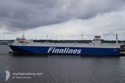
FINNMILL
Ro-Ro Cargo
Current Trip
| Time Travelled | 15 h, 19 mins |
|---|---|
| Remaining Time | 13 h, 54 mins |
| Distance Travelled | 272.39 nm |
| Remaining Distance | 258.36 nm |
| AVG Speed | 17.7 Knots |
| MAX Speed | 19.7 Knots |
| AVG Wind | 19.8 knots |
| MAX Wind | 23.6 knots |
| MIN Temp | -0.1°C / 31.82°F |
| MAX Temp | 1.6°C / 34.88°F |
| Draught | 6.4 m |
| Position Received | 6 h, 30 m ago |
Current Position
| Longitude | --- |
|---|---|
| Latitude | --- |
| Status | Under way using engine |
| Speed | 10 Knots |
| Course | 68° |
| Area | Baltic Sea |
| Station | T-AIS |
| Position Received | 6 h, 30 m ago |
Info
Information
The current position of FINNMILL is in Baltic Sea with coordinates 55.66716° / 15.63645° as reported on 2026-02-12 09:56 by AIS to our vessel tracker app. The vessel's current speed is 10 Knots and is heading at the port of HANKO. The estimated time of arrival as calculated by MyShipTracking vessel tracking app is 2026-02-13 08:20 LT
The vessel FINNMILL (IMO: 9212656, MMSI: 230642000) is a Ro-Ro Cargo that was built in 2002 ( 24 years old ). It's sailing under the flag of [FI] Finland.
In this page you can find informations about the vessels current position, last detected port calls, and current voyage information. If the vessels is not in coverage by AIS you will find the latest position.
The current position of FINNMILL is detected by our AIS receivers and we are not responsible for the reliability of the data. The last position was recorded while the vessel was in Coverage by the Ais receivers of our vessel tracking app.
The current draught of FINNMILL as reported by AIS is 6.4 meters
Weather
| Temperature | 0.1°C / 32.18°F |
|---|---|
| Wind Speed | 23 knots |
| Direction | 64° ENE |
| Pressure | 988.9 hPa |
| Humidity | 81 % |
| Cloud Coverage | 100 % |
Featured Company
Last Port Calls
| Port | Arrival | Departure | Time In Port |
|---|---|---|---|
| 2026-02-11 18:03 | 2026-02-12 02:07 | 8 h | |
| 2026-02-10 05:27 | 2026-02-10 16:28 | 11 h | |
| 2026-02-08 15:03 | 2026-02-09 01:32 | 10 h | |
| 2026-02-06 08:33 | 2026-02-07 11:30 | 1 d | |
| 2026-02-04 16:45 | 2026-02-05 03:08 | 10 h | |
| 2026-02-03 06:44 | 2026-02-03 14:38 | 7 h | |
| 2026-02-01 15:05 | 2026-02-02 01:47 | 10 h | |
| 2026-01-30 06:27 | 2026-01-31 10:51 | 1 d | |
| 2026-01-28 15:05 | 2026-01-29 01:04 | 9 h | |
| 2026-01-27 05:28 | 2026-01-27 11:37 | 6 h |
Most Visited Ports (Last year)
| Port | Arrivals | |
|---|---|---|
| 59 | ||
| 49 | ||
| 49 | ||
| 28 | ||
| 25 |
Last Trips
| Origin | Departure | Destination | Arrival | Distance | |
|---|---|---|---|---|---|
| 2026-02-10 16:28 | 2026-02-11 18:03 | 529.47 nm | |||
| 2026-02-09 01:32 | 2026-02-10 05:27 | 525.23 nm | |||
| 2026-02-07 11:30 | 2026-02-08 15:03 | 527.51 nm | |||
| 2026-02-05 03:08 | 2026-02-06 08:33 | 523.66 nm | |||
| 2026-02-03 14:38 | 2026-02-04 16:45 | 528.18 nm | |||
| 2026-02-02 01:47 | 2026-02-03 06:44 | 523.88 nm | |||
| 2026-01-31 10:51 | 2026-02-01 15:05 | 527.60 nm | |||
| 2026-01-29 01:04 | 2026-01-30 06:27 | 524.51 nm | |||
| 2026-01-27 11:37 | 2026-01-28 15:05 | 528.58 nm | |||
| 2026-01-26 23:07 | 2026-01-27 05:28 | 86.12 nm |
Events
| Time | Event | Details | Position / Dest | Info |
|---|---|---|---|---|
| 2026-02-12 10:01 | Status Changed | Default Under way using engine |
55.67354 / 15.66137
HANKO
|
Speed: 10 kn Course: 68° |
| 2026-02-12 09:56 | OUT of Coverage |
55.66716 / 15.63645
Baltic Sea
HANKO
|
Speed: 10 kn Course: 68° |
|
| 2026-02-12 09:14 | Change Sea Area | Swedish part of the Baltic Sea Danish part of the Kattegat |
55.62180 / 15.39274
Baltic Sea
HANKO
|
Speed: 19.1 kn Course: 69.1° |
| 2026-02-12 06:08 | Change Sea Area | Danish part of the Kattegat Swedish part of the Baltic Sea |
55.01718 / 14.08564
Kattegat
HANKO
|
Speed: 19.2 kn Course: 71.7° |
| 2026-02-12 05:50 | Change Sea Area | Swedish part of the Baltic Sea German part of the Baltic Sea |
54.98626 / 13.92681
Baltic Sea
HANKO
|
Speed: 19.1 kn Course: 71.4° |
| 2026-02-12 01:07 | PORT DEPARTURE |
|
54.19003 / 12.08771
HANKO
|
Speed: 9.6 kn Course: 342° |
| 2026-02-12 00:39 | START Moving |
54.13987 / 12.09590
[DE] ROSTOCK
|
Speed: 3.9 kn Course: 359° |
|
| 2026-02-12 00:18 | Draught Changed | 6.4 6.6 |
54.13787 / 12.09630
[DE] ROSTOCK
|
Speed: Course: 0° |
| 2026-02-12 00:18 | Status Changed | Under way using engine Moored |
54.13787 / 12.09629
[DE] ROSTOCK
|
Speed: Course: 0° |
| 2026-02-11 22:31 | ETA Changed | 2026/02/13 05:00 2026/02/11 16:00 |
54.13787 / 12.09629
[DE] ROSTOCK
|
Speed: Course: 0° |