
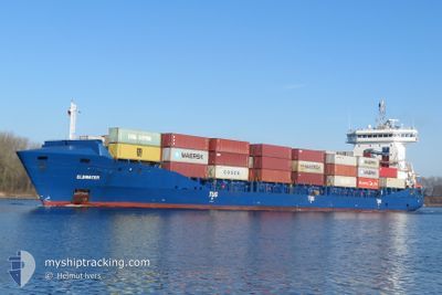
ELBWATER
Container Ship
Current Trip
| Time Travelled | 1 day |
|---|---|
| Remaining Time | 12 h, 50 mins |
| Distance Travelled | 319.61 nm |
| Remaining Distance | 186.85 nm |
| AVG Speed | 9.8 Knots |
| MAX Speed | 16.3 Knots |
| AVG Wind | 8.6 knots |
| MAX Wind | 17 knots |
| MIN Temp | -1.3°C / 29.66°F |
| MAX Temp | 4.2°C / 39.56°F |
| Draught | 6.6 m |
| Position Received | Now |
Current Position
| Longitude | --- |
|---|---|
| Latitude | --- |
| Status | Under way using engine |
| Speed | 14.8 Knots |
| Course | 117.4° |
| Area | Baltic Sea |
| Station | T-AIS |
| Position Received | Now |
Info
Information
The current position of ELBWATER is in Baltic Sea with coordinates 54.61633° / 11.07577° as reported on 2025-03-15 14:19 by AIS to our vessel tracker app. The vessel's current speed is 14.8 Knots and is heading at the port of SZCZECIN. The estimated time of arrival as calculated by MyShipTracking vessel tracking app is 2025-03-16 04:10 LT
The vessel ELBWATER (IMO: 9504073, MMSI: 210359000) is a Container Ship that was built in 2012 ( 13 years old ). It's sailing under the flag of [CY] Cyprus.
In this page you can find informations about the vessels current position, last detected port calls, and current voyage information. If the vessels is not in coverage by AIS you will find the latest position.
The current position of ELBWATER is detected by our AIS receivers and we are not responsible for the reliability of the data. The last position was recorded while the vessel was in Coverage by the Ais receivers of our vessel tracking app.
The current draught of ELBWATER as reported by AIS is 6.6 meters
Weather
| Temperature | 3.6°C / 38.48°F |
|---|---|
| Wind Speed | 8 knots |
| Direction | 353° N |
| Pressure | 1021.7 hPa |
| Humidity | 73.3 % |
| Cloud Coverage | 39 % |
Featured Company
Last Port Calls
| Port | Arrival | Departure | Time In Port |
|---|---|---|---|
| 2025-03-12 15:21 | 2025-03-13 23:05 | 1 d | |
| 2025-03-10 14:30 | 2025-03-12 07:03 | 1 d | |
| 2025-03-06 05:10 | 2025-03-07 20:41 | 1 d | |
| 2025-03-05 04:41 | 2025-03-05 04:46 | 4 m | |
| 2025-03-02 17:17 | 2025-03-04 14:30 | 1 d | |
| 2025-03-01 06:40 | 2025-03-02 00:30 | 17 h | |
| 2025-02-25 18:55 | 2025-02-26 13:54 | 18 h | |
| 2025-02-23 16:31 | 2025-02-24 17:14 | 1 d | |
| 2025-02-22 04:28 | 2025-02-22 12:40 | 8 h | |
| 2025-02-19 16:38 | 2025-02-20 03:09 | 10 h |
Most Visited Ports (Last year)
| Port | Arrivals | |
|---|---|---|
| 32 | ||
| 29 | ||
| 24 | ||
| 11 | ||
| 10 | ||
| 9 |
Last Trips
| Origin | Departure | Destination | Arrival | Distance | |
|---|---|---|---|---|---|
| 2025-03-12 07:03 | 2025-03-12 15:21 | 114.23 nm | |||
| 2025-03-07 20:41 | 2025-03-10 14:30 | 506.39 nm | |||
| 2025-03-05 04:46 | 2025-03-06 05:10 | 352.68 nm | |||
| 2025-03-04 14:30 | 2025-03-05 04:41 | 88.65 nm | |||
| 2025-03-02 00:30 | 2025-03-02 17:17 | 117.33 nm | |||
| 2025-02-26 13:54 | 2025-03-01 06:40 | 788.59 nm | |||
| 2025-02-24 17:14 | 2025-02-25 18:55 | 302.40 nm | |||
| 2025-02-22 12:40 | 2025-02-23 16:31 | 385.58 nm | |||
| 2025-02-20 03:09 | 2025-02-22 04:28 | 417.66 nm | |||
| 2025-02-18 15:01 | 2025-02-19 16:38 | 413.34 nm |
Events
| Time | Event | Details | Position / Dest | Info |
|---|---|---|---|---|
| 2025-03-15 14:07 | Change Sea Area | German part of the Baltic Sea Danish part of the Baltic Sea |
54.63903 / 11.00046
Baltic Sea
PLSZZ
|
Speed: 14.8 kn Course: 117.9° |
| 2025-03-15 13:34 | Change Sea Area | Danish part of the Baltic Sea Danish part of the Kattegat |
54.73253 / 10.85928
Baltic Sea
PLSZZ
|
Speed: 15.2 kn Course: 184.6° |
| 2025-03-15 08:19 | START Moving | 1 nm, West of KALUNDBORG |
55.66508 / 11.06079
PLSZZ
|
Speed: 5 kn Course: 292.2° |
| 2025-03-15 08:17 | Status Changed | Under way using engine Moored |
55.66419 / 11.06405
PLSZZ
|
Speed: Course: 286° |
| 2025-03-15 05:25 | Draught Changed | 6.6 7.2 |
55.66416 / 11.06409
PLSZZ
|
Speed: Course: 287° |
| 2025-03-15 05:25 | Destination Changed | PLSZZ DKKAL VIA NOK |
55.66416 / 11.06409
PLSZZ
|
Speed: Course: 287° |
| 2025-03-15 05:25 | ETA Changed | 2025/03/16 00:30 2025/03/14 23:00 |
55.66416 / 11.06409
PLSZZ
|
Speed: Course: 287° |
| 2025-03-15 00:13 | Status Changed | Moored Under way using engine |
55.66414 / 11.06415
DKKAL VIA NOK
|
Speed: Course: 286° |
| 2025-03-15 00:04 | STOP Moving | 0.91 nm, South West of KALUNDBORG |
55.66429 / 11.06394
DKKAL VIA NOK
|
Speed: 0.2 kn Course: 295° |
| 2025-03-14 17:32 | Change Sea Area | Danish part of the Kattegat Danish part of the Baltic Sea |
54.75646 / 10.87999
Kattegat
DKKAL VIA NOK
|
Speed: 12.5 kn Course: 354.8° |