

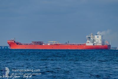
EAGLE BERGEN
Tanker

Current Trip
MARINER
| Time Travelled | 8 days |
|---|---|
| Remaining Time | --- |
| Distance Travelled | 598.35 nm |
| Remaining Distance | --- |
| AVG Speed | 22 Knots |
| MAX Speed | 22 Knots |
| AVG Wind | 13.1 knots |
| MAX Wind | 31.2 knots |
| MIN Temp | 0.5°C / 32.9°F |
| MAX Temp | 6.3°C / 43.34°F |
| Draught | 9.5 m |
| Position Received | Now |
Current Position
| Longitude | --- |
|---|---|
| Latitude | --- |
| Status | Under way using engine |
| Speed | 11.8 Knots |
| Course | 282.2° |
| Area | Skaggerak |
| Station | T-AIS |
| Position Received | Now |
Information
The current position of EAGLE BERGEN is in Skaggerak with coordinates 57.84139° / 10.68585° as reported on 2025-03-18 19:13 by AIS to our vessel tracker app. The vessel's current speed is 11.8 Knots
The vessel EAGLE BERGEN (IMO: 9676137, MMSI: 311000340) is a Tanker It's sailing under the flag of [BS] Bahamas.
In this page you can find informations about the vessels current position, last detected port calls, and current voyage information. If the vessels is not in coverage by AIS you will find the latest position.
The current position of EAGLE BERGEN is detected by our AIS receivers and we are not responsible for the reliability of the data. The last position was recorded while the vessel was in Coverage by the Ais receivers of our vessel tracking app.
The current draught of EAGLE BERGEN as reported by AIS is 9.5 meters
Weather
| Temperature | 5°C / 41°F |
|---|---|
| Wind Speed | 23 knots |
| Direction | 247° WSW |
| Pressure | 1021.6 hPa |
| Humidity | 87.7 % |
| Cloud Coverage | 7 % |


Featured Company
Last Port Calls
| Port | Arrival | Departure | Time In Port |
|---|---|---|---|
| 2025-03-08 16:15 | 2025-03-09 23:39 | 1 d | |
| 2025-02-23 11:16 | 2025-02-24 17:19 | 1 d | |
| 2025-02-12 09:07 | 2025-02-13 00:34 | 15 h | |
| 2025-02-01 23:33 | 2025-02-07 16:43 | 5 d | |
| 2025-01-31 19:34 | 2025-02-01 23:04 | 1 d | |
| 2025-01-14 19:41 | 2025-01-16 09:41 | 1 d |
Last Trips
| Origin | Departure | Destination | Arrival | Distance | |
|---|---|---|---|---|---|
| 2025-02-24 17:19 | 2025-03-08 16:15 | 1602.45 nm | |||
| 2025-02-13 00:34 | 2025-02-23 11:16 | 1252.12 nm | |||
| 2025-02-07 16:43 | 2025-02-12 09:07 | 854.81 nm | |||
| 2025-02-01 23:04 | 2025-02-01 23:33 | 2.25 nm | |||
| 2025-01-16 09:41 | 2025-01-31 19:34 | 1489.18 nm | |||
| 2024-12-25 13:51 | 2025-01-14 19:41 | 1724.91 nm |
Events
| Time | Event | Details | Position / Dest | Info |
|---|---|---|---|---|
| 2025-03-18 18:41 | Change Sea Area | Danish part of the Skaggerak Danish part of the Kattegat |
57.78518 / 10.82866
Skaggerak
MARINER
|
Speed: 13.7 kn Course: 4.2° |
| 2025-03-18 17:47 | START Moving | 3.23 nm, South East of SKAGEN |
57.67187 / 10.65974
MARINER
|
Speed: 3.1 kn Course: 82° |
| 2025-03-18 16:51 | Status Changed | Under way using engine At anchor |
57.67339 / 10.65596
MARINER
|
Speed: Course: 230° |
| 2025-03-18 15:47 | Destination Changed | MARINER SKAW ANCHOR |
57.67364 / 10.65558
MARINER
|
Speed: Course: 226° |
| 2025-03-18 15:47 | ETA Changed | 2025/03/20 11:00 2025/03/12 10:00 |
57.67364 / 10.65558
MARINER
|
Speed: Course: 226° |
| 2025-03-12 09:29 | Status Changed | At anchor Under way using engine |
57.67377 / 10.64919
SKAW ANCHOR
|
Speed: 0.2 kn Course: 157° |
| 2025-03-12 09:27 | STOP Moving | 2.94 nm, South East of SKAGEN |
57.67373 / 10.64944
SKAW ANCHOR
|
Speed: 0.3 kn Course: 164° |
| 2025-03-12 06:10 | Change Sea Area | Danish part of the Kattegat Swedish part of the Kattegat |
57.54567 / 11.30260
Kattegat
SKAW ANCHOR
|
Speed: 8.6 kn Course: 287.9° |
| 2025-03-12 01:13 | Change Sea Area | Swedish part of the Kattegat Danish part of the Kattegat |
56.91031 / 11.82863
Kattegat
SKAW ANCHOR
|
Speed: 8.6 kn Course: 338.7° |
| 2025-03-11 21:54 | Status Changed | Under way using engine Default |
56.48457 / 11.65685
SKAW ANCHOR
|
Speed: 7.7 kn Course: 33° |