

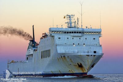
DRUJBA
Ro-Ro/Passenger Ship

Current Trip
| Time Travelled | 1 day |
|---|---|
| Remaining Time | 22 h, 23 mins |
| Distance Travelled | 173.39 nm |
| Remaining Distance | 461.41 nm |
| AVG Speed | 13.3 Knots |
| MAX Speed | 14 Knots |
| AVG Wind | 5.7 knots |
| MAX Wind | 9.5 knots |
| MIN Temp | 4.4°C / 39.92°F |
| MAX Temp | 8.3°C / 46.94°F |
| Draught | 5.5 m |
| Position Received | 12 h, 3 m ago |
Current Position
| Longitude | --- |
|---|---|
| Latitude | --- |
| Status | Under way using engine |
| Speed | 13.1 Knots |
| Course | 85.4° |
| Area | Black Sea |
| Station | T-AIS |
| Position Received | 12 h, 3 m ago |
Information
The current position of DRUJBA is in Black Sea with coordinates 42.46506° / 31.48463° as reported on 2025-03-22 14:47 by AIS to our vessel tracker app. The vessel's current speed is 13.1 Knots and is heading at the port of BATUMI. The estimated time of arrival as calculated by MyShipTracking vessel tracking app is 2025-03-24 05:13 LT
The vessel DRUJBA (IMO: 9031698, MMSI: 207277000) is a Ro-Ro/Passenger Ship that was built in 1994 ( 31 years old ). It's sailing under the flag of [BG] Bulgaria.
In this page you can find informations about the vessels current position, last detected port calls, and current voyage information. If the vessels is not in coverage by AIS you will find the latest position.
The current position of DRUJBA is detected by our AIS receivers and we are not responsible for the reliability of the data. The last position was recorded while the vessel was in Coverage by the Ais receivers of our vessel tracking app.
The current draught of DRUJBA as reported by AIS is 5.5 meters
Weather
| Temperature | 7.6°C / 45.68°F |
|---|---|
| Wind Speed | 5 knots |
| Direction | 43° NE |
| Pressure | 1025.8 hPa |
| Humidity | 71.2 % |
| Cloud Coverage | 1 % |


Featured Company
Last Port Calls
| Port | Arrival | Departure | Time In Port |
|---|---|---|---|
| 2025-03-20 15:38 | 2025-03-22 03:37 | 1 d | |
| 2025-03-17 15:18 | 2025-03-18 15:03 | 23 h | |
| 2025-03-14 14:21 | 2025-03-15 11:05 | 20 h | |
| 2025-03-11 23:13 | 2025-03-12 20:12 | 20 h | |
| 2025-03-08 22:53 | 2025-03-09 23:21 | 1 d | |
| 2025-03-06 07:38 | 2025-03-07 02:23 | 18 h | |
| 2025-03-03 05:41 | 2025-03-04 02:45 | 21 h | |
| 2025-02-27 12:20 | 2025-02-28 17:27 | 1 d | |
| 2025-02-20 08:29 | 2025-02-22 16:13 | 2 d | |
| 2025-02-17 09:22 | 2025-02-18 02:22 | 17 h |
Last Trips
| Origin | Departure | Destination | Arrival | Distance | |
|---|---|---|---|---|---|
| 2025-03-18 15:03 | 2025-03-20 15:38 | 634.22 nm | |||
| 2025-03-15 11:05 | 2025-03-17 15:18 | 638.18 nm | |||
| 2025-03-12 20:12 | 2025-03-14 14:21 | 636.81 nm | |||
| 2025-03-09 23:21 | 2025-03-11 23:13 | 633.06 nm | |||
| 2025-03-07 02:23 | 2025-03-08 22:53 | 653.24 nm | |||
| 2025-03-04 02:45 | 2025-03-06 07:38 | 633.48 nm | |||
| 2025-02-28 17:27 | 2025-03-03 05:41 | 647.98 nm | |||
| 2025-02-22 16:13 | 2025-02-27 12:20 | 711.18 nm | |||
| 2025-02-18 02:22 | 2025-02-20 08:29 | 634.26 nm | |||
| 2025-02-15 02:41 | 2025-02-17 09:22 | 631.66 nm |
Events
| Time | Event | Details | Position / Dest | Info |
|---|---|---|---|---|
| 2025-03-22 14:47 | OUT of Coverage |
42.46506 / 31.48463
Black Sea
GEBUS
|
Speed: 13.1 kn Course: 85.4° |
|
| 2025-03-22 13:00 | Draught Changed | 5.5 5.3 |
42.43374 / 30.95842
GEBUS
|
Speed: 13.5 kn Course: 85.2° |
| 2025-03-22 13:00 | Destination Changed | GEBUS BGBOJ |
42.43374 / 30.95842
GEBUS
|
Speed: 13.5 kn Course: 85.2° |
| 2025-03-22 13:00 | ETA Changed | 2025/03/24 05:00 2025/03/20 12:00 |
42.43374 / 30.95842
GEBUS
|
Speed: 13.5 kn Course: 85.2° |
| 2025-03-22 12:44 | Status Changed | Under way using engine Default |
42.42899 / 30.87721
BGBOJ
|
Speed: 14 kn Course: 86° |
| 2025-03-22 12:41 | Status Changed | Default Under way using engine |
42.42797 / 30.85833
BGBOJ
|
Speed: 14 kn Course: 85.8° |
| 2025-03-22 12:19 | Status Changed | Under way using engine Default |
42.42154 / 30.74445
BGBOJ
|
Speed: 13.4 kn Course: 92° |
| 2025-03-22 12:19 | IN Coverage |
42.42159 / 30.74541
Black Sea
|
Speed: 13.9 kn Course: 85.5° |
|
| 2025-03-22 01:37 | PORT DEPARTURE |
|
42.47501 / 27.53400
BGBOJ
|
Speed: 12.4 kn Course: 90° |
| 2025-03-22 01:14 | START Moving |
42.48047 / 27.45818
[BG] BURGAS
|
Speed: 6.5 kn Course: 126° |