
DANA
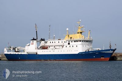
Fishery Research Vessel
Current Trip
| Time Travelled | 15 days |
|---|---|
| Remaining Time | 5 h, 47 mins |
| Distance Travelled | 1239.65 nm |
| Remaining Distance | 67.66 nm |
| AVG Speed | 7.2 Knots |
| MAX Speed | 11.6 Knots |
| AVG Wind | 23.5 knots |
| MAX Wind | 28.8 knots |
| MIN Temp | 1.4°C / 34.52°F |
| MAX Temp | 6.5°C / 43.7°F |
| Draught | 6.1 m |
| Position Received | 1 m ago |
Current Position
| Longitude | --- |
|---|---|
| Latitude | --- |
| Status | Under way using engine |
| Speed | 11.1 Knots |
| Course | 38.1° |
| Area | North Sea |
| Station | T-AIS |
| Position Received | 1 m ago |
Information
The current position of DANA is in North Sea with coordinates 57.08712° / 8.28033° as reported on 2025-02-23 04:41 by AIS to our vessel tracker app. The vessel's current speed is 11.1 Knots and is heading at the port of HIRTSHALS. The estimated time of arrival as calculated by MyShipTracking vessel tracking app is 2025-02-23 10:29 LT
The vessel DANA (IMO: 7912680, MMSI: 219384000) is a Fishery Research Vessel that was built in 1981 ( 44 years old ). It's sailing under the flag of [DK] Denmark.
In this page you can find informations about the vessels current position, last detected port calls, and current voyage information. If the vessels is not in coverage by AIS you will find the latest position.
The current position of DANA is detected by our AIS receivers and we are not responsible for the reliability of the data. The last position was recorded while the vessel was in Coverage by the Ais receivers of our vessel tracking app.
The current draught of DANA as reported by AIS is 6.1 meters
Weather
| Temperature | 5.9°C / 42.62°F |
|---|---|
| Wind Speed | 10 knots |
| Direction | 233° SW |
| Pressure | 1017.9 hPa |
| Humidity | 91.8 % |
| Cloud Coverage | 58 % |
Featured Company
Most Visited Ports (Last year)
| Port | Arrivals | |
|---|---|---|
| 9 | ||
| 4 | ||
| 2 | ||
| 2 | ||
| 1 |
Events
| Time | Event | Details | Position / Dest | Info |
|---|---|---|---|---|
| 2025-02-23 03:43 | IN Coverage |
56.95220 / 8.07164
North Sea
DKHIR
|
Speed: 11.1 kn Course: 39.9° |
|
| 2025-02-23 02:34 | OUT of Coverage |
56.79138 / 7.79331
North Sea
DKHIR
|
Speed: 11.4 kn Course: 44.4° |
|
| 2025-02-23 02:27 | IN Coverage |
56.79138 / 7.79331
North Sea
DKHIR
|
Speed: 11.4 kn Course: 44.4° |
|
| 2025-02-23 01:23 | Destination Changed | DKHIR RESEARCH NORTH SEA |
56.62912 / 7.51728
DKHIR
|
Speed: 11.1 kn Course: 43.1° |
| 2025-02-23 01:11 | OUT of Coverage |
56.60149 / 7.47082
North Sea
RESEARCH NORTH SEA
|
Speed: 11.1 kn Course: 43.5° |
|
| 2025-02-22 23:38 | IN Coverage |
56.41495 / 7.16932
North Sea
RESEARCH NORTH SEA
|
Speed: 3.2 kn Course: 40.7° |
|
| 2025-02-22 16:39 | OUT of Coverage |
56.09868 / 7.26778
North Sea
RESEARCH NORTH SEA
|
Speed: 10.4 kn Course: 261.2° |
|
| 2025-02-22 15:01 | IN Coverage |
56.09860 / 7.32819
North Sea
RESEARCH NORTH SEA
|
Speed: 1.7 kn Course: 206.9° |
|
| 2025-02-22 13:20 | OUT of Coverage |
56.14595 / 7.38298
North Sea
RESEARCH NORTH SEA
|
Speed: 2.3 kn Course: 210.5° |
|
| 2025-02-22 13:20 | IN Coverage |
56.14595 / 7.38298
North Sea
RESEARCH NORTH SEA
|
Speed: 2.3 kn Course: 210.5° |