
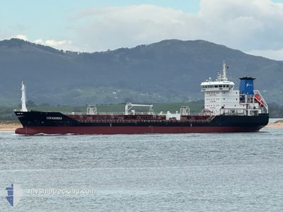
COVADONGA
Oil/Chemical Tanker
Current Trip
| Time Travelled | 1 day |
|---|---|
| Remaining Time | --- |
| Distance Travelled | 185.72 nm |
| Remaining Distance | --- |
| AVG Speed | 13.7 Knots |
| MAX Speed | 15.1 Knots |
| AVG Wind | 17.6 knots |
| MAX Wind | 26 knots |
| MIN Temp | 0.3°C / 32.54°F |
| MAX Temp | 3.9°C / 39.02°F |
| Draught | 5.2 m |
| Position Received | 1 d ago |
Current Position
| Longitude | --- |
|---|---|
| Latitude | --- |
| Status | Under way using engine |
| Speed | 13.8 Knots |
| Course | 121° |
| Area | Baltic Sea |
| Station | T-AIS |
| Position Received | 1 d ago |
Info
Information
The current position of COVADONGA is in Baltic Sea with coordinates 54.75022° / 13.55322° as reported on 2026-01-02 16:17 by AIS to our vessel tracker app. The vessel's current speed is 13.8 Knots
The vessel COVADONGA (IMO: 9300489, MMSI: 255803540) is a Oil/Chemical Tanker that was built in 2005 ( 21 years old ). It's sailing under the flag of [PT] Portugal.
In this page you can find informations about the vessels current position, last detected port calls, and current voyage information. If the vessels is not in coverage by AIS you will find the latest position.
The current position of COVADONGA is detected by our AIS receivers and we are not responsible for the reliability of the data. The last position was recorded while the vessel was in Coverage by the Ais receivers of our vessel tracking app.
The current draught of COVADONGA as reported by AIS is 5.2 meters
Weather
| Temperature | -0.7°C / 30.74°F |
|---|---|
| Wind Speed | 10 knots |
| Direction | 249° WSW |
| Pressure | 995.3 hPa |
| Humidity | 65.5 % |
| Cloud Coverage | 99 % |
Featured Company
Last Port Calls
| Port | Arrival | Departure | Time In Port |
|---|---|---|---|
| 2026-01-02 07:36 | 2026-01-02 07:39 | 3 m | |
| 2025-12-28 06:22 | 2025-12-29 18:18 | 1 d | |
| 2025-12-19 16:06 | 2025-12-19 17:15 | 1 h | |
| 2025-12-16 09:53 | 2025-12-18 12:34 | 2 d | |
| 2025-12-05 22:05 | 2025-12-06 23:17 | 1 d | |
| 2025-12-05 11:27 | 2025-12-05 12:44 | 1 h | |
| 2025-11-24 12:59 | 2025-11-26 20:54 | 2 d | |
| 2025-11-07 07:31 | 2025-11-12 20:14 | 5 d |
Last Trips
| Origin | Departure | Destination | Arrival | Distance | |
|---|---|---|---|---|---|
| 2025-12-29 18:18 | 2026-01-02 07:36 | 1039.20 nm | |||
| 2025-12-19 17:15 | 2025-12-28 06:22 | 2590.17 nm | |||
| 2025-12-18 12:34 | 2025-12-19 16:06 | 162.53 nm | |||
| 2025-12-06 23:17 | 2025-12-16 09:53 | 689.77 nm | |||
| 2025-12-05 12:44 | 2025-12-05 22:05 | 105.60 nm | |||
| 2025-11-26 20:54 | 2025-12-05 11:27 | 2662.52 nm | |||
| 2025-11-12 20:14 | 2025-11-24 12:59 | 3415.75 nm | |||
| 2025-10-31 08:41 | 2025-11-07 07:31 | 2358.57 nm |
Events
| Time | Event | Details | Position / Dest | Info |
|---|---|---|---|---|
| 2026-01-02 21:00 | STOP Moving | 4.15 nm, North of SWINOUJSCIE |
53.97385 / 14.25133
PLSZZ
|
Speed: Course: 257° |
| 2026-01-02 16:25 | Status Changed | Default Under way using engine |
54.72649 / 13.58063
PLSZZ
|
Speed: 13.8 kn Course: 121° |
| 2026-01-02 16:17 | OUT of Coverage |
54.75022 / 13.55322
Baltic Sea
PLSZZ
|
Speed: 13.8 kn Course: 121° |
|
| 2026-01-02 12:06 | Change Sea Area | German part of the Baltic Sea Danish part of the Baltic Sea |
54.41149 / 12.12498
Baltic Sea
PLSZZ
|
Speed: 15.2 kn Course: 89° |
| 2026-01-02 10:22 | Change Sea Area | Danish part of the Baltic Sea German part of the Baltic Sea |
54.50410 / 11.44538
Baltic Sea
PLSZZ
|
Speed: 15 kn Course: 115.8° |
| 2026-01-02 08:40 | Change Sea Area | German part of the Baltic Sea Danish part of the Baltic Sea |
54.56924 / 10.78274
Baltic Sea
PLSZZ
|
Speed: 14.2 kn Course: 84.5° |
| 2026-01-02 08:13 | Change Sea Area | Danish part of the Baltic Sea German part of the Baltic Sea |
54.55914 / 10.60480
Baltic Sea
PLSZZ
|
Speed: 13.7 kn Course: 86.6° |
| 2026-01-02 07:32 | ETA Changed | 2026/01/02 21:00 2026/01/02 17:00 |
54.49712 / 10.34905
PLSZZ
|
Speed: 13.9 kn Course: 63.2° |
| 2026-01-02 07:26 | ETA Changed | 2026/01/02 17:00 2026/01/01 17:00 |
54.48637 / 10.31265
PLSZZ
|
Speed: 13.5 kn Course: 59.4° |
| 2026-01-02 07:13 | Change Sea Area | German part of the Baltic Sea German part of the North Sea |
54.45979 / 10.26461
Baltic Sea
|
Speed: 12.5 kn Course: 33.2° |