
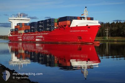
CONTSHIPS BOREALIS
Cargo A
Current Trip
| Time Travelled | 1 day |
|---|---|
| Remaining Time | 1 day |
| Distance Travelled | 385.40 nm |
| Remaining Distance | 578.36 nm |
| AVG Speed | 10 Knots |
| MAX Speed | 18.2 Knots |
| AVG Wind | 7.7 knots |
| MAX Wind | 18.8 knots |
| MIN Temp | 3.4°C / 38.12°F |
| MAX Temp | 15.2°C / 59.36°F |
| Draught | 7.8 m |
| Position Received | 1 m ago |
Current Position
| Longitude | 11.60580° |
|---|---|
| Latitude | 54.45937° |
| Status | Under way using engine |
| Speed | 15.7 Knots |
| Course | 115° |
| Area | Baltic Sea |
| Station | T-AIS |
| Position Received | 1 m ago |
Info
Information
The current position of CONTSHIPS BOREALIS is in Baltic Sea with coordinates 54.45937° / 11.60580° as reported on 2024-04-27 18:06 by AIS to our vessel tracker app. The vessel's current speed is 15.7 Knots and is heading at the port of HELSINKI. The estimated time of arrival as calculated by MyShipTracking vessel tracking app is 2024-04-29 09:43 LT
The vessel CONTSHIPS BOREALIS (IMO: 9866249, MMSI: 210028000) is a Cargo A It's sailing under the flag of [CY] Cyprus.
In this page you can find informations about the vessels current position, last detected port calls, and current voyage information. If the vessels is not in coverage by AIS you will find the latest position.
The current position of CONTSHIPS BOREALIS is detected by our AIS receivers and we are not responsible for the reliability of the data. The last position was recorded while the vessel was in Coverage by the Ais receivers of our vessel tracking app.
The current draught of CONTSHIPS BOREALIS as reported by AIS is 7.8 meters
Weather
| Temperature | 9.6°C / 49.28°F |
|---|---|
| Wind Speed | 19 knots |
| Direction | 97° E |
| Pressure | 1010.4 hPa |
| Humidity | 86.1 % |
| Cloud Coverage | 99 % |
Featured Company
Last Port Calls
| Port | Arrival | Departure | Time In Port |
|---|---|---|---|
| 2024-04-25 08:39 | 2024-04-26 10:18 | 1 d | |
| 2024-04-24 13:14 | 2024-04-24 22:11 | 8 h | |
| 2024-04-23 03:51 | 2024-04-23 19:01 | 15 h | |
| 2024-04-17 19:51 | 2024-04-18 07:20 | 11 h | |
| 2024-04-16 12:29 | 2024-04-17 16:17 | 1 d | |
| 2024-04-12 09:26 | 2024-04-13 14:23 | 1 d | |
| 2024-04-11 19:11 | 2024-04-12 01:21 | 6 h | |
| 2024-04-10 01:30 | 2024-04-11 01:48 | 1 d | |
| 2024-04-06 14:15 | 2024-04-07 06:11 | 15 h | |
| 2024-04-04 03:22 | 2024-04-04 17:27 | 14 h |
Most Visited Ports (Last year)
| Port | Arrivals | |
|---|---|---|
| 16 | ||
| 14 | ||
| 14 | ||
| 13 | ||
| 12 | ||
| 12 |
Last Trips
| Origin | Departure | Destination | Arrival | Distance | |
|---|---|---|---|---|---|
| 2024-04-25 00:11 | 2024-04-25 10:39 | 109.52 nm | |||
| 2024-04-23 20:01 | 2024-04-24 15:14 | 289.65 nm | |||
| 2024-04-18 10:20 | 2024-04-23 04:51 | 1446.09 nm | |||
| 2024-04-17 19:17 | 2024-04-17 22:51 | 46.25 nm | |||
| 2024-04-13 16:23 | 2024-04-16 15:29 | 977.11 nm | |||
| 2024-04-12 03:21 | 2024-04-12 11:26 | 110.07 nm | |||
| 2024-04-11 02:48 | 2024-04-11 21:11 | 289.93 nm | |||
| 2024-04-07 09:11 | 2024-04-10 02:30 | 857.21 nm | |||
| 2024-04-04 20:27 | 2024-04-06 17:15 | 535.18 nm | |||
| 2024-04-02 11:38 | 2024-04-04 06:22 | 209.65 nm |
Events
| Time | Event | Details | Position / Dest | Info |
|---|---|---|---|---|
| 2024-04-27 17:41 | Change Sea Area | Danish part of the Baltic Sea German part of the Baltic Sea |
54.50616 / 11.43812
Baltic Sea
FIHEL
|
Speed: 15.6 kn Course: 115.1° |
| 2024-04-27 16:02 | Change Sea Area | German part of the Baltic Sea Danish part of the Baltic Sea |
54.56224 / 10.77319
Baltic Sea
FIHEL
|
Speed: 14.4 kn Course: 82.8° |
| 2024-04-27 15:41 | Change Sea Area | Danish part of the Baltic Sea German part of the Baltic Sea |
54.55203 / 10.62863
Baltic Sea
FIHEL
|
Speed: 14.5 kn Course: 82.7° |
| 2024-04-27 14:35 | Change Sea Area | German part of the Baltic Sea German part of the North Sea |
54.46191 / 10.25544
Baltic Sea
FIHEL
|
Speed: 9.9 kn Course: 29.2° |
| 2024-04-27 13:51 | START Moving | 1.28 nm, South West of STICKENHΟRN SPORT |
54.36539 / 10.14711
FIHEL
|
Speed: 3.2 kn Course: 105° |
| 2024-04-27 13:12 | STOP Moving | 1.36 nm, South West of STICKENHΟRN SPORT |
54.36626 / 10.14142
FIHEL
|
Speed: 0.3 kn Course: 103° |
| 2024-04-27 09:49 | START Moving | 3.77 nm, South West of RENDSBURG |
54.26602 / 9.62722
FIHEL
|
Speed: 3.2 kn Course: 18° |
| 2024-04-27 09:33 | STOP Moving | 3.9 nm, South West of RENDSBURG |
54.26394 / 9.62565
FIHEL
|
Speed: 0.3 kn Course: 14° |
| 2024-04-27 09:14 | ETA Changed | 2024/04/29 05:00 2024/04/29 08:00 |
54.24298 / 9.61253
FIHEL
|
Speed: 6.3 kn Course: 18.5° |
| 2024-04-27 08:45 | START Moving | 7.14 nm, North East of FISCHERHUTTE |
54.20141 / 9.55901
FIHEL
|
Speed: 3.5 kn Course: 52° |