
CONNECTOR
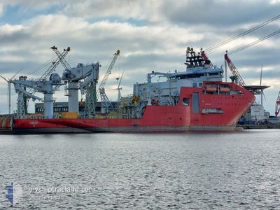
Offshore Supply Ship
Current Trip
| Time Travelled | 12 days |
|---|---|
| Remaining Time | 1 day |
| Distance Travelled | 354.90 nm |
| Remaining Distance | 252.95 nm |
| AVG Speed | 10.4 Knots |
| MAX Speed | 14.5 Knots |
| AVG Wind | 7.3 knots |
| MAX Wind | 15 knots |
| MIN Temp | 5°C / 41°F |
| MAX Temp | 13.6°C / 56.48°F |
| Draught | 7.5 m |
| Position Received | 1 m ago |
Current Position
| Longitude | -2.61896° |
|---|---|
| Latitude | 49.83957° |
| Status | Under way using engine |
| Speed | 7.7 Knots |
| Course | 74.3° |
| Area | English Channel |
| Station | T-AIS |
| Position Received | 1 m ago |
Info
Information
The current position of CONNECTOR is in English Channel with coordinates 49.83957° / -2.61896° as reported on 2024-05-07 22:48 by AIS to our vessel tracker app. The vessel's current speed is 7.7 Knots and is heading at the port of ZEEBRUGGE. The estimated time of arrival as calculated by MyShipTracking vessel tracking app is 2024-05-09 05:44 LT
The vessel CONNECTOR (IMO: 9435480, MMSI: 253751000) is a Offshore Supply Ship that was built in 2011 ( 13 years old ). It's sailing under the flag of [LU] Luxembourg.
In this page you can find informations about the vessels current position, last detected port calls, and current voyage information. If the vessels is not in coverage by AIS you will find the latest position.
The current position of CONNECTOR is detected by our AIS receivers and we are not responsible for the reliability of the data. The last position was recorded while the vessel was in Coverage by the Ais receivers of our vessel tracking app.
The current draught of CONNECTOR as reported by AIS is 7.5 meters
Weather
| Temperature | 13°C / 55.4°F |
|---|---|
| Wind Speed | 6 knots |
| Direction | 322° NW |
| Pressure | 1027.3 hPa |
| Humidity | 81.6 % |
| Cloud Coverage | 4 % |
Featured Company
Most Visited Ports (Last year)
| Port | Arrivals | |
|---|---|---|
| 2 | ||
| 2 | ||
| 2 | ||
| 1 | ||
| 1 | ||
| 1 |
Events
| Time | Event | Details | Position / Dest | Info |
|---|---|---|---|---|
| 2024-05-07 19:26 | Change Sea Area | Guernsey part of the English Channel United Kingdom part of the English Channel |
49.74802 / -3.32792
English Channel
ZEEBRUGGE
|
Speed: 8.3 kn Course: 88.1° |
| 2024-05-07 10:13 | Detected in Sea | United Kingdom part of the English Channel |
49.74595 / -5.44862
English Channel
ZEEBRUGGE
|
Speed: 7.7 kn Course: 89° |
| 2024-05-07 09:11 | IN Coverage |
49.74553 / -5.66136
Celtic Sea
ZEEBRUGGE
|
Speed: 8.2 kn Course: 90.2° |
|
| 2024-05-07 04:36 | OUT of Coverage |
50.28854 / -6.01454
Celtic Sea
ZEEBRUGGE
|
Speed: 8.9 kn Course: 181.8° |
|
| 2024-05-07 03:56 | IN Coverage |
50.38369 / -6.01306
Celtic Sea
ZEEBRUGGE
|
Speed: 8.4 kn Course: 179.7° |
|
| 2024-05-07 01:54 | OUT of Coverage |
50.67005 / -6.03885
Celtic Sea
ZEEBRUGGE
|
Speed: 8.3 kn Course: 178.1° |
|
| 2024-05-06 22:18 | Destination Changed | ZEEBRUGGE OFFSHORE WORKS |
51.19272 / -6.12381
ZEEBRUGGE
|
Speed: 8.9 kn Course: 176.7° |
| 2024-05-06 22:18 | ETA Changed | 2024/05/09 07:00 2025/04/25 09:00 |
51.19272 / -6.12381
ZEEBRUGGE
|
Speed: 8.9 kn Course: 176.7° |
| 2024-05-06 21:55 | IN Coverage |
51.24841 / -6.13088
Celtic Sea
|
Speed: 8.7 kn Course: 173.8° |
|
| 2024-05-06 20:50 | OUT of Coverage |
51.40662 / -6.16395
Celtic Sea
|
Speed: 9.5 kn Course: 175.8° |