
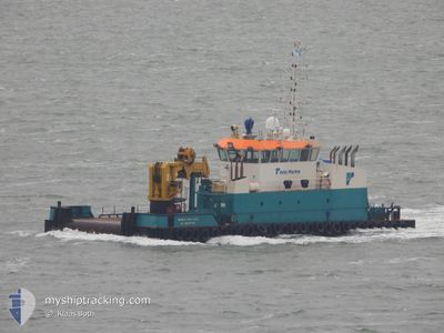
COASTAL CHALLENGER
Work Vessel
Current Trip
| Time Travelled | 2 days |
|---|---|
| Remaining Time | 4 h, 33 mins |
| Distance Travelled | 31.54 nm |
| Remaining Distance | 355.83 nm |
| AVG Speed | 5.5 Knots |
| MAX Speed | 8.2 Knots |
| AVG Wind | 9.8 knots |
| MAX Wind | 13 knots |
| MIN Temp | 25°C / 77°F |
| MAX Temp | 27.8°C / 82.04°F |
| Draught | 2.4 m |
| Position Received | 2023-06-24 15:33 |
Current Position
| Longitude | -61.80169° |
|---|---|
| Latitude | 10.43674° |
| Status | Under way using engine |
| Speed | 5.6 Knots |
| Course | 224° |
| Area | Caribbean Sea |
| Station | T-AIS |
| Position Received | 2023-06-24 15:33 |
Info
Information
The current position of COASTAL CHALLENGER is in Caribbean Sea with coordinates 10.43674° / -61.80169° as reported on 2023-06-24 15:33 by AIS to our vessel tracker app. The vessel's current speed is 5.6 Knots and is heading at the port of PORT OF SPAIN. The estimated time of arrival as calculated by MyShipTracking vessel tracking app is 2024-04-29 13:24 LT
The vessel COASTAL CHALLENGER (IMO: 9647320, MMSI: 244913000) is a Work Vessel that was built in 2012 ( 12 years old ). It's sailing under the flag of [NL] Netherlands.
In this page you can find informations about the vessels current position, last detected port calls, and current voyage information. If the vessels is not in coverage by AIS you will find the latest position.
The current position of COASTAL CHALLENGER is detected by our AIS receivers and we are not responsible for the reliability of the data. The last position was recorded while the vessel was in Coverage by the Ais receivers of our vessel tracking app.
The current draught of COASTAL CHALLENGER as reported by AIS is 2.4 meters
Weather
| Temperature | 27.7°C / 81.86°F |
|---|---|
| Wind Speed | 12 knots |
| Direction | 64° ENE |
| Pressure | 1009.8 hPa |
| Humidity | 76.6 % |
| Cloud Coverage | 61 % |
Featured Company
Last Port Calls
| Port | Arrival | Departure | Time In Port |
|---|---|---|---|
| 2024-04-26 16:31 | 2024-04-27 07:50 | 15 h | |
| 2024-04-25 23:22 | 2024-04-26 07:30 | 8 h | |
| 2024-04-14 14:01 | 2024-04-25 16:34 | 11 d | |
| 2024-04-14 03:39 | 2024-04-14 11:54 | 8 h | |
| 2024-04-13 18:51 | 2024-04-13 19:51 | 1 h | |
| 2024-04-13 14:34 | 2024-04-13 16:51 | 2 h | |
| 2024-04-12 14:29 | 2024-04-12 20:16 | 5 h | |
| 2024-04-12 02:50 | 2024-04-12 12:28 | 9 h | |
| 2024-04-10 23:12 | 2024-04-11 20:00 | 20 h | |
| 2024-04-09 21:17 | 2024-04-10 16:55 | 19 h |
Most Visited Ports (Last year)
| Port | Arrivals | |
|---|---|---|
| 92 | ||
| 23 | ||
| 5 | ||
| 1 | ||
| 1 |
Last Trips
| Origin | Departure | Destination | Arrival | Distance | |
|---|---|---|---|---|---|
| 2024-04-26 03:30 | 2024-04-26 12:31 | 23.55 nm | |||
| 2024-04-25 12:34 | 2024-04-25 19:22 | 26.44 nm | |||
| 2024-04-14 07:54 | 2024-04-14 10:01 | 1.21 nm | |||
| 2024-04-13 15:51 | 2024-04-13 23:39 | 1.91 nm | |||
| 2024-04-13 12:51 | 2024-04-13 14:51 | 1.01 nm | |||
| 2024-04-12 16:16 | 2024-04-13 10:34 | 53.35 nm | |||
| 2024-04-12 08:28 | 2024-04-12 10:29 | 0.88 nm | |||
| 2024-04-11 16:00 | 2024-04-11 22:50 | 26.39 nm | |||
| 2024-04-10 12:55 | 2024-04-10 19:12 | 28.64 nm | |||
| 2024-04-09 12:27 | 2024-04-09 17:17 | 26.83 nm |
Events
| Time | Event | Details | Position / Dest | Info |
|---|---|---|---|---|
| 2024-04-28 21:58 | STOP Moving | 11.29 nm, North of GEORGETOWN |
6.97250 / -58.12715
PORT OF SPAIN
|
Speed: 0.1 kn Course: 64° |
| 2024-04-28 21:33 | START Moving | 11.15 nm, North of GEORGETOWN |
6.96874 / -58.12203
PORT OF SPAIN
|
Speed: 3.3 kn Course: 327° |
| 2024-04-28 21:19 | STOP Moving | 11.5 nm, North of GEORGETOWN |
6.97339 / -58.11754
PORT OF SPAIN
|
Speed: 0.3 kn Course: 1° |
| 2024-04-28 21:09 | START Moving | 11.19 nm, North of GEORGETOWN |
6.96941 / -58.12195
PORT OF SPAIN
|
Speed: 6.3 kn Course: 122° |
| 2024-04-28 00:21 | STOP Moving | 11.35 nm, North of GEORGETOWN |
6.97222 / -58.12250
PORT OF SPAIN
|
Speed: Course: 69° |
| 2024-04-28 00:17 | START Moving | 11.43 nm, North of GEORGETOWN |
6.97327 / -58.12127
PORT OF SPAIN
|
Speed: 3.5 kn Course: 235° |
| 2024-04-27 21:27 | STOP Moving | 11.45 nm, North of GEORGETOWN |
6.97282 / -58.11851
PORT OF SPAIN
|
Speed: 0.2 kn Course: 50° |
| 2024-04-27 21:14 | START Moving | 11.76 nm, North of GEORGETOWN |
6.97954 / -58.12310
PORT OF SPAIN
|
Speed: 6 kn Course: 46° |
| 2024-04-27 19:52 | STOP Moving | 11.85 nm, North of GEORGETOWN |
6.97823 / -58.11339
PORT OF SPAIN
|
Speed: 0.1 kn Course: 68° |
| 2024-04-27 19:43 | START Moving | 11.67 nm, North of GEORGETOWN |
6.97599 / -58.11637
PORT OF SPAIN
|
Speed: 6 kn Course: 54° |