

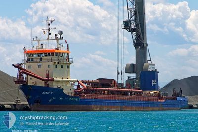
BRAGE R
Trailing Suction Hopper Dredger

Current Trip
| Time Travelled | 5 h, 1 mins |
|---|---|
| Remaining Time | 2 h, 26 mins |
| Distance Travelled | 47.65 nm |
| Remaining Distance | 28.47 nm |
| AVG Speed | 10.4 Knots |
| MAX Speed | 12.2 Knots |
| AVG Wind | 8.1 knots |
| MAX Wind | 10.2 knots |
| MIN Temp | 10.7°C / 51.26°F |
| MAX Temp | 16.8°C / 62.24°F |
| Draught | 4 m |
| Position Received | 1 m ago |
Current Position
| Longitude | --- |
|---|---|
| Latitude | --- |
| Status | Under way using engine |
| Speed | 8.9 Knots |
| Course | 276.2° |
| Area | North Atlantic Ocean |
| Station | T-AIS |
| Position Received | 1 m ago |
Information
The current position of BRAGE R is in North Atlantic Ocean with coordinates 36.77468° / -6.51006° as reported on 2025-03-03 12:01 by AIS to our vessel tracker app. The vessel's current speed is 8.9 Knots and is heading at the port of HUELVA. The estimated time of arrival as calculated by MyShipTracking vessel tracking app is 2025-03-03 15:28 LT
The vessel BRAGE R (IMO: 9144380, MMSI: 246366000) is a Trailing Suction Hopper Dredger that was built in 1996 ( 29 years old ). It's sailing under the flag of [NL] Netherlands.
In this page you can find informations about the vessels current position, last detected port calls, and current voyage information. If the vessels is not in coverage by AIS you will find the latest position.
The current position of BRAGE R is detected by our AIS receivers and we are not responsible for the reliability of the data. The last position was recorded while the vessel was in Coverage by the Ais receivers of our vessel tracking app.
The current draught of BRAGE R as reported by AIS is 4 meters
Weather
| Temperature | 15.5°C / 59.9°F |
|---|---|
| Wind Speed | 8 knots |
| Direction | 150° SSE |
| Pressure | 1012.6 hPa |
| Humidity | 79.9 % |
| Cloud Coverage | 100 % |


Featured Company
Last Port Calls
| Port | Arrival | Departure | Time In Port |
|---|---|---|---|
| 2025-02-28 23:37 | 2025-03-03 08:01 | 2 d | |
| 2025-02-28 15:26 | 2025-02-28 16:48 | 1 h | |
| 2025-02-28 08:55 | 2025-02-28 09:55 | 1 h | |
| 2025-02-28 02:44 | 2025-02-28 03:58 | 1 h | |
| 2025-02-27 14:20 | 2025-02-27 14:59 | 38 m | |
| 2025-02-25 20:30 | 2025-02-27 08:06 | 1 d | |
| 2025-02-25 18:27 | 2025-02-25 19:58 | 1 h | |
| 2025-02-25 13:10 | 2025-02-25 14:17 | 1 h | |
| 2025-02-25 07:39 | 2025-02-25 08:38 | 59 m | |
| 2025-02-25 00:41 | 2025-02-25 01:34 | 52 m |
Most Visited Ports (Last year)
| Port | Arrivals | |
|---|---|---|
| 510 | ||
| 390 | ||
| 330 | ||
| 44 | ||
| 17 | ||
| 12 |
Last Trips
| Origin | Departure | Destination | Arrival | Distance | |
|---|---|---|---|---|---|
| 2025-02-28 16:48 | 2025-02-28 23:37 | 8.61 nm | |||
| 2025-02-28 09:55 | 2025-02-28 15:26 | 12.16 nm | |||
| 2025-02-28 03:58 | 2025-02-28 08:55 | 11.36 nm | |||
| 2025-02-27 14:59 | 2025-02-28 02:44 | 22.87 nm | |||
| 2025-02-27 08:06 | 2025-02-27 14:20 | 12.03 nm | |||
| 2025-02-25 19:58 | 2025-02-25 20:30 | 0.88 nm | |||
| 2025-02-25 14:17 | 2025-02-25 18:27 | 11.21 nm | |||
| 2025-02-25 08:38 | 2025-02-25 13:10 | 10.84 nm | |||
| 2025-02-25 01:34 | 2025-02-25 07:39 | 11.44 nm | |||
| 2025-02-24 12:55 | 2025-02-25 00:41 | 21.79 nm |
Events
| Time | Event | Details | Position / Dest | Info |
|---|---|---|---|---|
| 2025-03-03 10:25 | Status Changed | Under way using engine Default |
36.90475 / -6.30310
ESHUE
|
Speed: 10.8 kn Course: 241° |
| 2025-03-03 10:20 | Status Changed | Default Under way using engine |
36.90986 / -6.28705
ESHUE
|
Speed: 11.4 kn Course: 331.2° |
| 2025-03-03 09:56 | Status Changed | Under way using engine Default |
36.90750 / -6.20918
ESHUE
|
Speed: 11.5 kn Course: 193° |
| 2025-03-03 09:56 | IN Coverage |
36.90477 / -6.21352
North Atlantic Ocean
ESHUE
|
Speed: 12.1 kn Course: 234.8° |
|
| 2025-03-03 07:55 | Status Changed | Default Under way using engine |
37.21078 / -6.08141
ESHUE
|
Speed: 6.5 kn Course: 206.3° |
| 2025-03-03 07:46 | OUT of Coverage |
37.22362 / -6.06761
North Atlantic Ocean
ESHUE
|
Speed: 6.5 kn Course: 206.3° |
|
| 2025-03-03 07:06 | Destination Changed | ESHUE SEVLLIA |
37.29928 / -6.03626
ESHUE
|
Speed: 7.2 kn Course: 246.1° |
| 2025-03-03 07:06 | ETA Changed | 2025/03/03 15:00 2025/02/09 16:00 |
37.29928 / -6.03626
ESHUE
|
Speed: 7.2 kn Course: 246.1° |
| 2025-03-03 07:01 | PORT DEPARTURE |
|
37.30529 / -6.02592
SEVLLIA
|
Speed: 5.4 kn Course: 242° |
| 2025-03-03 06:51 | Status Changed | Under way using engine Default |
37.31680 / -6.01142
[ES] SEVILLA
|
Speed: 4.6 kn Course: 210° |