
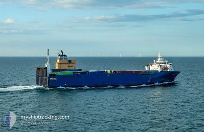
BORE BAY
Vehicles Carrier
Current Trip
| Time Travelled | 1 day |
|---|---|
| Remaining Time | 1 mins |
| Distance Travelled | 453.22 nm |
| Remaining Distance | 4.26 nm |
| AVG Speed | 10.8 Knots |
| MAX Speed | 14.5 Knots |
| AVG Wind | 18.2 knots |
| MAX Wind | 32 knots |
| MIN Temp | -1.8°C / 28.76°F |
| MAX Temp | 5.2°C / 41.36°F |
| Draught | 5.8 m |
| Position Received | Now |
Current Position
| Longitude | --- |
|---|---|
| Latitude | --- |
| Status | Under way using engine |
| Speed | 8.4 Knots |
| Course | 68.8° |
| Area | North Sea |
| Station | T-AIS |
| Position Received | Now |
Info
Information
The current position of BORE BAY is in North Sea with coordinates 58.92978° / 5.56189° as reported on 2026-01-04 20:32 by AIS to our vessel tracker app. The vessel's current speed is 8.4 Knots and is heading at the port of TANANGER. The estimated time of arrival as calculated by MyShipTracking vessel tracking app is 2026-01-04 21:34 LT
The vessel BORE BAY (IMO: 9122007, MMSI: 230357000) is a Vehicles Carrier that was built in 1997 ( 29 years old ). It's sailing under the flag of [FI] Finland.
In this page you can find informations about the vessels current position, last detected port calls, and current voyage information. If the vessels is not in coverage by AIS you will find the latest position.
The current position of BORE BAY is detected by our AIS receivers and we are not responsible for the reliability of the data. The last position was recorded while the vessel was in Coverage by the Ais receivers of our vessel tracking app.
The current draught of BORE BAY as reported by AIS is 5.8 meters
Weather
| Temperature | -1.4°C / 29.48°F |
|---|---|
| Wind Speed | 4 knots |
| Direction | 93° E |
| Pressure | 1006.8 hPa |
| Humidity | 35.1 % |
| Cloud Coverage | 5 % |
Featured Company
Last Port Calls
| Port | Arrival | Departure | Time In Port |
|---|---|---|---|
| 2026-01-01 15:42 | 2026-01-03 05:34 | 1 d | |
| 2025-12-29 21:14 | 2025-12-30 10:43 | 13 h | |
| 2025-12-29 19:25 | 2025-12-29 20:56 | 1 h | |
| 2025-12-29 11:47 | 2025-12-29 15:15 | 3 h | |
| 2025-12-22 08:25 | 2025-12-29 07:13 | 6 d | |
| 2025-12-22 01:30 | 2025-12-22 02:48 | 1 h | |
| 2025-12-21 19:34 | 2025-12-21 23:22 | 3 h | |
| 2025-12-19 17:44 | 2025-12-20 13:49 | 20 h | |
| 2025-12-17 19:17 | 2025-12-18 12:44 | 17 h | |
| 2025-12-16 14:00 | 2025-12-16 16:20 | 2 h |
Last Trips
| Origin | Departure | Destination | Arrival | Distance | |
|---|---|---|---|---|---|
| 2025-12-30 10:43 | 2026-01-01 15:42 | 477.80 nm | |||
| 2025-12-29 20:56 | 2025-12-29 21:14 | 1.35 nm | |||
| 2025-12-29 15:15 | 2025-12-29 19:25 | 41.35 nm | |||
| 2025-12-29 07:13 | 2025-12-29 11:47 | 50.45 nm | |||
| 2025-12-22 02:48 | 2025-12-22 08:25 | 76.80 nm | |||
| 2025-12-21 23:22 | 2025-12-22 01:30 | 27.56 nm | |||
| 2025-12-20 13:49 | 2025-12-21 19:34 | 388.58 nm | |||
| 2025-12-18 12:44 | 2025-12-19 17:44 | 332.56 nm | |||
| 2025-12-16 16:20 | 2025-12-17 19:17 | 264.39 nm | |||
| 2025-12-16 11:19 | 2025-12-16 14:00 | 26.48 nm |
Events
| Time | Event | Details | Position / Dest | Info |
|---|---|---|---|---|
| 2026-01-04 10:27 | Detected in Sea | Norwegian part of the North Sea |
57.10946 / 5.57696
North Sea
NORIV
|
Speed: 11.8 kn Course: 348.6° |
| 2026-01-04 10:27 | Status Changed | Under way using engine Default |
57.10946 / 5.57696
NORIV
|
Speed: 13 kn Course: 349° |
| 2026-01-04 10:27 | IN Coverage |
57.10946 / 5.57696
North Sea
NORIV
|
Speed: 11.8 kn Course: 348.6° |
|
| 2026-01-04 03:28 | Status Changed | Default Under way using engine |
55.63167 / 5.89667
NORIV
|
Speed: 14 kn Course: 10.8° |
| 2026-01-04 03:17 | OUT of Coverage |
55.59312 / 5.87950
North Sea
NORIV
|
Speed: 14 kn Course: 10.8° |
|
| 2026-01-04 02:58 | Change Sea Area | Danish part of the North Sea German part of the North Sea |
55.52217 / 5.84861
North Sea
NORIV
|
Speed: 14.4 kn Course: 13.3° |
| 2026-01-04 02:56 | Status Changed | Under way using engine Default |
55.51337 / 5.84473
NORIV
|
Speed: 14 kn Course: 15° |
| 2026-01-04 02:43 | Status Changed | Default Under way using engine |
55.46167 / 5.82167
NORIV
|
Speed: 14.4 kn Course: 13.7° |
| 2026-01-04 02:28 | Status Changed | Under way using engine Default |
55.40731 / 5.79634
NORIV
|
Speed: 14 kn Course: 16° |
| 2026-01-04 02:13 | Status Changed | Default Under way using engine |
55.34833 / 5.76833
NORIV
|
Speed: 13.9 kn Course: 15° |