
BFR
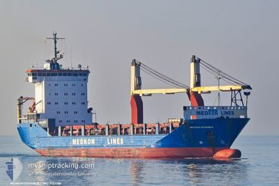
General Cargo
Current Trip
| Time Travelled | 12 h, 38 mins |
|---|---|
| Remaining Time | 3 days |
| Distance Travelled | 52.03 nm |
| Remaining Distance | 455.01 nm |
| AVG Speed | 6.3 Knots |
| MAX Speed | 9.4 Knots |
| AVG Wind | 13.9 knots |
| MAX Wind | 16 knots |
| MIN Temp | 9.5°C / 49.1°F |
| MAX Temp | 10.6°C / 51.08°F |
| Draught | 7.5 m |
| Position Received | 1 m ago |
Current Position
| Longitude | --- |
|---|---|
| Latitude | --- |
| Status | Under way using engine |
| Speed | 6.3 Knots |
| Course | 26° |
| Area | Sea of Marmara |
| Station | T-AIS |
| Position Received | 1 m ago |
Info
Information
The current position of BFR is in Sea of Marmara with coordinates 41.06240° / 29.04562° as reported on 2025-12-08 14:43 by AIS to our vessel tracker app. The vessel's current speed is 6.3 Knots and is heading at the port of NOVOROSSIYSK. The estimated time of arrival as calculated by MyShipTracking vessel tracking app is 2025-12-11 20:21 LT
The vessel BFR (IMO: 9103386, MMSI: 374819000) is a General Cargo that was built in 1995 ( 30 years old ). It's sailing under the flag of [PA] Panama.
In this page you can find informations about the vessels current position, last detected port calls, and current voyage information. If the vessels is not in coverage by AIS you will find the latest position.
The current position of BFR is detected by our AIS receivers and we are not responsible for the reliability of the data. The last position was recorded while the vessel was in Coverage by the Ais receivers of our vessel tracking app.
The current draught of BFR as reported by AIS is 7.5 meters
Weather
| Temperature | 9.6°C / 49.28°F |
|---|---|
| Wind Speed | 11 knots |
| Direction | 356° N |
| Pressure | 1020.8 hPa |
| Humidity | 75 % |
| Cloud Coverage | 100 % |
Featured Company
Last Port Calls
| Port | Arrival | Departure | Time In Port |
|---|---|---|---|
| 2025-12-07 17:16 | 2025-12-08 05:06 | 11 h | |
| 2025-12-07 03:22 | 2025-12-07 11:48 | 8 h | |
| 2025-12-05 14:24 | 2025-12-05 20:29 | 6 h | |
| 2025-11-24 05:40 | 2025-12-01 03:14 | 6 d | |
| 2025-11-17 16:29 | 2025-11-18 03:37 | 11 h | |
| 2025-11-16 04:30 | 2025-11-16 12:27 | 7 h | |
| 2025-11-15 06:40 | 2025-11-15 17:36 | 10 h | |
| 2025-11-12 01:50 | 2025-11-12 04:08 | 2 h | |
| 2025-11-11 17:48 | 2025-11-12 01:23 | 7 h | |
| 2025-11-06 21:40 | 2025-11-08 03:31 | 1 d |
Most Visited Ports (Last year)
| Port | Arrivals | |
|---|---|---|
| 20 | ||
| 18 | ||
| 17 | ||
| 9 | ||
| 7 | ||
| 6 |
Last Trips
| Origin | Departure | Destination | Arrival | Distance | |
|---|---|---|---|---|---|
| 2025-12-07 11:48 | 2025-12-07 17:16 | 47.88 nm | |||
| 2025-12-05 20:29 | 2025-12-07 03:22 | 276.70 nm | |||
| 2025-12-01 03:14 | 2025-12-05 14:24 | 893.23 nm | |||
| 2025-11-18 03:37 | 2025-11-24 05:40 | 900.49 nm | |||
| 2025-11-16 12:27 | 2025-11-17 16:29 | 245.49 nm | |||
| 2025-11-15 17:36 | 2025-11-16 04:30 | 53.91 nm | |||
| 2025-11-12 04:08 | 2025-11-15 06:40 | 537.38 nm | |||
| 2025-11-12 01:23 | 2025-11-12 01:50 | 4.94 nm | |||
| 2025-11-08 03:31 | 2025-11-11 17:48 | 536.04 nm | |||
| 2025-11-06 12:34 | 2025-11-06 21:40 | 53.45 nm |
Events
| Time | Event | Details | Position / Dest | Info |
|---|---|---|---|---|
| 2025-12-08 10:37 | Status Changed | Under way using engine Not under command |
40.70850 / 28.78699
RUNVS
|
Speed: 5.8 kn Course: 13.6° |
| 2025-12-08 10:23 | START Moving | 16.13 nm, South of YESILKOY |
40.68890 / 28.77812
RUNVS
|
Speed: 3.2 kn Course: 62° |
| 2025-12-08 08:20 | STOP Moving | 14.05 nm, South of YESILKOY |
40.72476 / 28.77182
RUNVS
|
Speed: 0.2 kn Course: 6° |
| 2025-12-08 07:39 | START Moving | 18.17 nm, South of YESILKOY |
40.65725 / 28.75474
RUNVS
|
Speed: 3.7 kn Course: 60° |
| 2025-12-08 03:50 | STOP Moving | 13.07 nm, South of AMBARLI |
40.74288 / 28.70463
RUNVS
|
Speed: 0.1 kn Course: 326° |
| 2025-12-08 03:47 | Status Changed | Not under command Under way using engine |
40.74338 / 28.70639
RUNVS
|
Speed: 4.7 kn Course: 258° |
| 2025-12-08 02:06 | PORT DEPARTURE |
|
40.95581 / 28.67768
RUNVS
|
Speed: 7.5 kn Course: 188° |
| 2025-12-08 02:03 | START Moving |
40.96199 / 28.67720
[TR] AMBARLI
|
Speed: 4.5 kn Course: 168° |
|
| 2025-12-08 01:57 | Status Changed | Under way using engine Moored |
40.96472 / 28.67640
[TR] AMBARLI
|
Speed: Course: 175° |
| 2025-12-08 01:50 | Draught Changed | 7.5 6.9 |
40.96470 / 28.67637
[TR] AMBARLI
|
Speed: Course: 175° |