
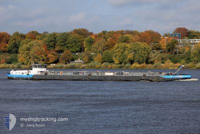
BERND DEYMANN
Tanker
Current Trip
| Time Travelled | 3 days |
|---|---|
| Remaining Time | --- |
| Distance Travelled | 136.83 nm |
| Remaining Distance | --- |
| AVG Speed | 6.2 Knots |
| MAX Speed | 12.5 Knots |
| AVG Wind | 7.9 knots |
| MAX Wind | 11.5 knots |
| MIN Temp | 3.7°C / 38.66°F |
| MAX Temp | 7.4°C / 45.32°F |
| Draught | 1 m |
| Position Received | 6 h, 45 m ago |
Current Position
| Longitude | --- |
|---|---|
| Latitude | --- |
| Status | Moored |
| Speed | |
| Course | --- |
| Area | North Sea |
| Station | T-AIS |
| Position Received | 6 h, 45 m ago |
Info
Information
The current position of BERND DEYMANN is in North Sea with coordinates 53.43012° / 10.34782° as reported on 2025-03-02 21:39 by AIS to our vessel tracker app. The vessel's current speed is 0 Knots
The vessel BERND DEYMANN (MMSI: 211549350) is a Tanker It's sailing under the flag of [DE] Germany.
In this page you can find informations about the vessels current position, last detected port calls, and current voyage information. If the vessels is not in coverage by AIS you will find the latest position.
The current position of BERND DEYMANN is detected by our AIS receivers and we are not responsible for the reliability of the data. The last position was recorded while the vessel was in Coverage by the Ais receivers of our vessel tracking app.
The current draught of BERND DEYMANN as reported by AIS is 1 meters
Weather
| Temperature | 4.3°C / 39.74°F |
|---|---|
| Wind Speed | 5 knots |
| Direction | 254° WSW |
| Pressure | 1030.8 hPa |
| Humidity | 88.1 % |
| Cloud Coverage | 97 % |
Featured Company
Last Port Calls
| Port | Arrival | Departure | Time In Port |
|---|---|---|---|
| 2025-02-27 12:15 | 2025-02-27 12:20 | 4 m | |
| 2025-02-24 15:53 | 2025-02-25 03:57 | 12 h | |
| 2025-02-23 00:39 | 2025-02-23 07:53 | 7 h | |
| 2025-02-22 11:05 | 2025-02-22 19:32 | 8 h | |
| 2025-02-21 14:41 | 2025-02-22 10:51 | 20 h | |
| 2025-02-21 13:56 | 2025-02-21 14:36 | 39 m | |
| 2025-02-18 18:30 | 2025-02-21 07:02 | 2 d | |
| 2025-02-08 14:56 | 2025-02-09 09:39 | 18 h | |
| 2025-02-08 08:27 | 2025-02-08 13:35 | 5 h | |
| 2025-02-03 18:55 | 2025-02-05 07:22 | 1 d |
Most Visited Ports (Last year)
| Port | Arrivals | |
|---|---|---|
| 22 | ||
| 16 | ||
| 10 | ||
| 8 | ||
| 7 | ||
| 6 |
Last Trips
| Origin | Departure | Destination | Arrival | Distance | |
|---|---|---|---|---|---|
| 2025-02-25 04:57 | 2025-02-27 13:15 | 79.35 nm | |||
| 2025-02-23 08:53 | 2025-02-24 16:53 | 122.56 nm | |||
| 2025-02-22 20:32 | 2025-02-23 01:39 | 30.88 nm | |||
| 2025-02-22 11:51 | 2025-02-22 12:05 | 0.20 nm | |||
| 2025-02-21 15:36 | 2025-02-21 15:41 | 0.33 nm | |||
| 2025-02-21 08:02 | 2025-02-21 14:56 | 50.78 nm | |||
| 2025-02-09 10:39 | 2025-02-18 19:30 | 393.59 nm | |||
| 2025-02-08 14:35 | 2025-02-08 15:56 | 14.74 nm | |||
| 2025-02-05 08:22 | 2025-02-08 09:27 | 42.25 nm | |||
| 2025-02-03 15:49 | 2025-02-03 19:55 | 38.25 nm |
Events
| Time | Event | Details | Position / Dest | Info |
|---|---|---|---|---|
| 2025-03-02 21:39 | OUT of Coverage |
53.43012 / 10.34782
North Sea
|
Speed: Course: 511° |
|
| 2025-03-02 21:39 | IN Coverage |
53.43012 / 10.34782
North Sea
|
Speed: Course: 511° |
|
| 2025-03-02 18:03 | OUT of Coverage |
53.43014 / 10.34780
North Sea
|
Speed: Course: 511° |
|
| 2025-03-02 18:03 | IN Coverage |
53.43014 / 10.34780
North Sea
|
Speed: Course: 511° |
|
| 2025-03-02 15:43 | OUT of Coverage |
53.43015 / 10.34779
North Sea
|
Speed: Course: 511° |
|
| 2025-03-02 15:24 | STOP Moving | 0.39 nm, West of GEESTHACHT |
53.43025 / 10.34790
HAMBURG PORT TRAFFI
|
Speed: 0.3 kn Course: 511° |
| 2025-03-02 13:53 | START Moving | 4.27 nm, South of ARTLENBURG |
53.30796 / 10.49081
HAMBURG PORT TRAFFI
|
Speed: 5.7 kn Course: 5° |
| 2025-03-02 12:20 | STOP Moving | 5.39 nm, South of ARTLENBURG |
53.28919 / 10.48744
HAMBURG PORT TRAFFI
|
Speed: 0.1 kn Course: 511° |
| 2025-03-02 12:01 | ETA Changed | 2026/02/27 19:38 2025/02/27 19:38 |
53.26478 / 10.48523
HAMBURG PORT TRAFFI
|
Speed: 5.7 kn Course: 358.8° |
| 2025-03-02 11:45 | IN Coverage |
53.23970 / 10.48730
North Sea
|
Speed: 5.9 kn Course: 352.7° |