
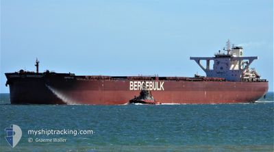
BERGE K2
Cargo
Current Trip
| Time Travelled | 11 days |
|---|---|
| Remaining Time | 9 h, 44 mins |
| Distance Travelled | 3758.14 nm |
| Remaining Distance | 133.49 nm |
| AVG Speed | 13.8 Knots |
| MAX Speed | 18.3 Knots |
| AVG Wind | 9 knots |
| MAX Wind | 19 knots |
| MIN Temp | 8.9°C / 48.02°F |
| MAX Temp | 30.2°C / 86.36°F |
| Draught | 11.2 m |
| Position Received | Now |
Current Position
| Longitude | 117.99440° |
|---|---|
| Latitude | -18.19441° |
| Status | Under way using engine |
| Speed | 13.7 Knots |
| Course | 171.3° |
| Area | Indian Ocean |
| Station | T-AIS |
| Position Received | Now |
Info
Information
The current position of BERGE K2 is in Indian Ocean with coordinates -18.19441° / 117.99440° as reported on 2024-05-11 15:23 by AIS to our vessel tracker app. The vessel's current speed is 13.7 Knots and is heading at the port of PORT HEDLAND. The estimated time of arrival as calculated by MyShipTracking vessel tracking app is 2024-05-12 01:08 LT
The vessel BERGE K2 (IMO: 9709506, MMSI: 235111759) is a Cargo It's sailing under the flag of [GB] United Kingdom.
In this page you can find informations about the vessels current position, last detected port calls, and current voyage information. If the vessels is not in coverage by AIS you will find the latest position.
The current position of BERGE K2 is detected by our AIS receivers and we are not responsible for the reliability of the data. The last position was recorded while the vessel was in Coverage by the Ais receivers of our vessel tracking app.
The current draught of BERGE K2 as reported by AIS is 11.2 meters
Weather
| Temperature | 27.8°C / 82.04°F |
|---|---|
| Wind Speed | 10 knots |
| Direction | 96° E |
| Pressure | 1015.2 hPa |
| Humidity | 64.7 % |
| Cloud Coverage | 6 % |
Featured Company
Last Port Calls
| Port | Arrival | Departure | Time In Port |
|---|---|---|---|
| 2024-04-26 01:00 | 2024-04-30 07:56 | 4 d | |
| 2024-04-10 16:46 | 2024-04-12 05:17 | 1 d | |
| 2024-03-19 18:36 | 2024-03-27 07:33 | 7 d | |
| 2024-03-03 14:25 | 2024-03-05 08:28 | 1 d |
Most Visited Ports (Last year)
| Port | Arrivals | |
|---|---|---|
| 9 | ||
| 4 | ||
| 2 | ||
| 1 | ||
| 1 |
Last Trips
| Origin | Departure | Destination | Arrival | Distance | |
|---|---|---|---|---|---|
| 2024-04-12 13:17 | 2024-04-26 09:00 | 3907.13 nm | |||
| 2024-03-27 13:33 | 2024-04-11 00:46 | 3171.77 nm | |||
| 2024-03-05 16:28 | 2024-03-20 00:36 | 2789.43 nm | |||
| 2024-02-16 10:47 | 2024-03-03 22:25 | 3857.71 nm |
Events
| Time | Event | Details | Position / Dest | Info |
|---|---|---|---|---|
| 2024-05-11 11:20 | Status Changed | Under way using engine Default |
-17.30406 / 117.76816
PORT HEDLAND
|
Speed: 13.7 kn Course: 165° |
| 2024-05-11 11:16 | Status Changed | Default Under way using engine |
-17.28744 / 117.76397
PORT HEDLAND
|
Speed: 13.7 kn Course: 165.8° |
| 2024-05-11 11:10 | Status Changed | Under way using engine Default |
-17.26825 / 117.75911
PORT HEDLAND
|
Speed: 13.7 kn Course: 166° |
| 2024-05-11 10:24 | Status Changed | Default Under way using engine |
-17.09711 / 117.71339
PORT HEDLAND
|
Speed: 13.2 kn Course: 167.9° |
| 2024-05-11 08:59 | Status Changed | Under way using engine Default |
-16.79469 / 117.63943
PORT HEDLAND
|
Speed: 13.3 kn Course: 162° |
| 2024-05-11 08:59 | IN Coverage |
-16.80190 / 117.64136
Indian Ocean
PORT HEDLAND
|
Speed: 13.2 kn Course: 165.9° |
|
| 2024-05-11 07:33 | Status Changed | Default Under way using engine |
-16.48249 / 117.55336
PORT HEDLAND
|
Speed: 13.7 kn Course: 164.7° |
| 2024-05-11 07:27 | Status Changed | Under way using engine Default |
-16.45898 / 117.54710
PORT HEDLAND
|
Speed: 13.8 kn Course: 166° |
| 2024-05-11 07:27 | OUT of Coverage |
-16.45898 / 117.54710
Indian Ocean
PORT HEDLAND
|
Speed: 13.7 kn Course: 164.7° |
|
| 2024-05-11 07:21 | Status Changed | Default Under way using engine |
-16.43660 / 117.54131
PORT HEDLAND
|
Speed: 13.8 kn Course: 164.7° |