

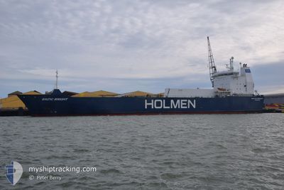
BALTIC BRIGHT
Vehicles Carrier

Current Trip
| Time Travelled | 3 days |
|---|---|
| Remaining Time | 1 day |
| Distance Travelled | 682.88 nm |
| Remaining Distance | 493.59 nm |
| AVG Speed | 9.8 Knots |
| MAX Speed | 15.6 Knots |
| AVG Wind | 22.9 knots |
| MAX Wind | 33.2 knots |
| MIN Temp | 0.9°C / 33.62°F |
| MAX Temp | 4.8°C / 40.64°F |
| Draught | 5 m |
| Position Received | Now |
Current Position
| Longitude | --- |
|---|---|
| Latitude | --- |
| Status | Under way using engine |
| Speed | 11.6 Knots |
| Course | 180.8° |
| Area | Kattegat |
| Station | T-AIS |
| Position Received | Now |
Information
The current position of BALTIC BRIGHT is in Kattegat with coordinates 55.79931° / 12.69199° as reported on 2025-02-21 11:06 by AIS to our vessel tracker app. The vessel's current speed is 11.6 Knots and is heading at the port of HALLSTAVIK. The estimated time of arrival as calculated by MyShipTracking vessel tracking app is 2025-02-23 07:01 LT
The vessel BALTIC BRIGHT (IMO: 9129263, MMSI: 230042000) is a Vehicles Carrier that was built in 1996 ( 29 years old ). It's sailing under the flag of [FI] Finland.
In this page you can find informations about the vessels current position, last detected port calls, and current voyage information. If the vessels is not in coverage by AIS you will find the latest position.
The current position of BALTIC BRIGHT is detected by our AIS receivers and we are not responsible for the reliability of the data. The last position was recorded while the vessel was in Coverage by the Ais receivers of our vessel tracking app.
The current draught of BALTIC BRIGHT as reported by AIS is 5 meters
Weather
| Temperature | 2.6°C / 36.68°F |
|---|---|
| Wind Speed | 11 knots |
| Direction | 165° SSE |
| Pressure | 1022.7 hPa |
| Humidity | 97.1 % |
| Cloud Coverage | 100 % |


Featured Company
Last Port Calls
| Port | Arrival | Departure | Time In Port |
|---|---|---|---|
| 2025-02-16 20:18 | 2025-02-18 09:11 | 1 d | |
| 2025-02-09 09:59 | 2025-02-11 12:10 | 2 d | |
| 2025-02-02 20:56 | 2025-02-04 11:32 | 1 d | |
| 2025-01-26 09:40 | 2025-01-28 12:11 | 2 d | |
| 2025-01-19 18:16 | 2025-01-21 07:04 | 1 d | |
| 2025-01-12 13:48 | 2025-01-14 12:09 | 1 d | |
| 2025-01-05 20:53 | 2025-01-07 19:39 | 1 d | |
| 2025-01-04 15:19 | 2025-01-04 16:38 | 1 h | |
| 2024-12-29 07:39 | 2024-12-30 14:41 | 1 d | |
| 2024-12-21 12:52 | 2024-12-23 18:09 | 2 d |
Most Visited Ports (Last year)
| Port | Arrivals | |
|---|---|---|
| 27 | ||
| 25 | ||
| 2 | ||
| 2 |
Last Trips
| Origin | Departure | Destination | Arrival | Distance | |
|---|---|---|---|---|---|
| 2025-02-11 12:10 | 2025-02-16 20:18 | 1276.40 nm | |||
| 2025-02-04 11:32 | 2025-02-09 09:59 | 1186.43 nm | |||
| 2025-01-28 12:11 | 2025-02-02 20:56 | 1278.74 nm | |||
| 2025-01-21 07:04 | 2025-01-26 09:40 | 1193.32 nm | |||
| 2025-01-14 12:09 | 2025-01-19 18:16 | 1276.16 nm | |||
| 2025-01-07 19:39 | 2025-01-12 13:48 | 1194.84 nm | |||
| 2025-01-04 16:38 | 2025-01-05 20:53 | 370.70 nm | |||
| 2024-12-30 14:41 | 2025-01-04 15:19 | 721.62 nm | |||
| 2024-12-23 18:09 | 2024-12-29 07:39 | 1190.13 nm | |||
| 2024-12-21 12:08 | 2024-12-21 12:52 | 2.52 nm |
Events
| Time | Event | Details | Position / Dest | Info |
|---|---|---|---|---|
| 2025-02-21 08:38 | Change Sea Area | Danish part of the Kattegat Swedish part of the Kattegat |
56.19225 / 12.39203
Kattegat
SEHAK
|
Speed: 10.6 kn Course: 164.4° |
| 2025-02-21 00:02 | Change Sea Area | Swedish part of the Kattegat Danish part of the Kattegat |
57.52800 / 11.32523
Kattegat
SEHAK
|
Speed: 7 kn Course: 137.3° |
| 2025-02-20 21:01 | Change Sea Area | Danish part of the Kattegat Danish part of the Skaggerak |
57.78311 / 10.87082
Kattegat
SEHAK
|
Speed: 7.8 kn Course: 117.2° |
| 2025-02-20 12:28 | Change Sea Area | Danish part of the Skaggerak Danish part of the North Sea |
57.17706 / 8.51531
Skaggerak
SEHAK
|
Speed: 10.5 kn Course: 55.3° |
| 2025-02-20 03:35 | Detected in Sea | Danish part of the North Sea |
55.86784 / 6.74476
North Sea
SEHAK
|
Speed: 11.2 kn Course: 40.5° |
| 2025-02-20 03:34 | Status Changed | Under way using engine Default |
55.86667 / 6.74296
SEHAK
|
Speed: 10.5 kn Course: 40° |
| 2025-02-20 03:34 | IN Coverage |
55.86784 / 6.74476
North Sea
SEHAK
|
Speed: 11.2 kn Course: 40.5° |
|
| 2025-02-18 19:43 | Status Changed | Default Under way using engine |
52.42412 / 2.90137
SEHAK
|
Speed: 9.3 kn Course: 31.6° |
| 2025-02-18 19:35 | OUT of Coverage |
52.40646 / 2.88398
North Sea
SEHAK
|
Speed: 9.3 kn Course: 31.6° |
|
| 2025-02-18 19:26 | Status Changed | Under way using engine Default |
52.38759 / 2.86558
SEHAK
|
Speed: 9.3 kn Course: 31° |