
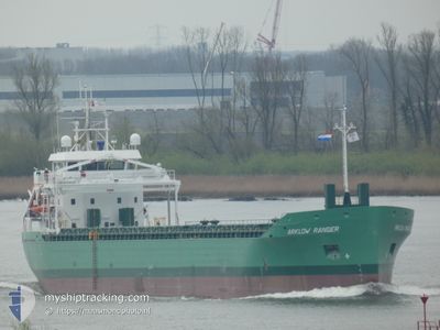
ARKLOW RANGER
Cargo
Current Trip
| Time Travelled | 3 days |
|---|---|
| Remaining Time | 12 h, 6 mins |
| Distance Travelled | 606.94 nm |
| Remaining Distance | 288.77 nm |
| AVG Speed | 10.3 Knots |
| MAX Speed | 11.6 Knots |
| AVG Wind | 13.3 knots |
| MAX Wind | 30 knots |
| MIN Temp | 12.3°C / 54.14°F |
| MAX Temp | 18.9°C / 66.02°F |
| Draught | 6.7 m |
| Position Received | 15 h, 35 m ago |
Current Position
| Longitude | 5.24042° |
|---|---|
| Latitude | 57.19056° |
| Status | Under way using engine |
| Speed | 10.3 Knots |
| Course | 255.5° |
| Area | North Sea |
| Station | T-AIS |
| Position Received | 15 h, 35 m ago |
Info
Information
The current position of ARKLOW RANGER is in North Sea with coordinates 57.19056° / 5.24042° as reported on 2024-07-03 06:11 by AIS to our vessel tracker app. The vessel's current speed is 10.3 Knots and is heading at the port of LEITH. The estimated time of arrival as calculated by MyShipTracking vessel tracking app is 2024-07-04 09:53 LT
The vessel ARKLOW RANGER (IMO: 9923243, MMSI: 250014107) is a Cargo It's sailing under the flag of [IE] Ireland.
In this page you can find informations about the vessels current position, last detected port calls, and current voyage information. If the vessels is not in coverage by AIS you will find the latest position.
The current position of ARKLOW RANGER is detected by our AIS receivers and we are not responsible for the reliability of the data. The last position was recorded while the vessel was in Coverage by the Ais receivers of our vessel tracking app.
The current draught of ARKLOW RANGER as reported by AIS is 6.7 meters
Weather
| Temperature | 13.7°C / 56.66°F |
|---|---|
| Wind Speed | 25 knots |
| Direction | 245° WSW |
| Pressure | 994.4 hPa |
| Humidity | 82.2 % |
| Cloud Coverage | 48 % |
Featured Company
Last Port Calls
| Port | Arrival | Departure | Time In Port |
|---|---|---|---|
| 2024-06-28 10:59 | 2024-06-30 19:36 | 2 d | |
| 2024-06-22 14:44 | 2024-06-22 15:44 | 59 m | |
| 2024-06-21 00:00 | 2024-06-22 13:07 | 1 d | |
| 2024-06-20 22:38 | 2024-06-20 22:51 | 13 m | |
| 2024-06-10 16:24 | 2024-06-15 13:09 | 4 d | |
| 2024-06-03 03:50 | 2024-06-05 15:30 | 2 d | |
| 2024-05-28 16:24 | 2024-05-31 13:02 | 2 d | |
| 2024-05-26 08:24 | 2024-05-27 16:49 | 1 d | |
| 2024-05-26 07:08 | 2024-05-26 07:27 | 18 m | |
| 2024-05-17 14:33 | 2024-05-22 11:43 | 4 d |
Last Trips
| Origin | Departure | Destination | Arrival | Distance | |
|---|---|---|---|---|---|
| 2024-06-22 17:44 | 2024-06-28 12:59 | 721.16 nm | |||
| 2024-06-22 15:07 | 2024-06-22 16:44 | 9.59 nm | |||
| 2024-06-21 00:51 | 2024-06-21 02:00 | 7.17 nm | |||
| 2024-06-15 15:09 | 2024-06-21 00:38 | 1359.63 nm | |||
| 2024-06-05 16:30 | 2024-06-10 18:24 | 1204.30 nm | |||
| 2024-05-31 14:02 | 2024-06-03 04:50 | 319.16 nm | |||
| 2024-05-27 17:49 | 2024-05-28 17:24 | 266.26 nm | |||
| 2024-05-26 08:27 | 2024-05-26 09:24 | 3.60 nm | |||
| 2024-05-22 13:43 | 2024-05-26 08:08 | 554.40 nm | |||
| 2024-05-10 20:02 | 2024-05-17 16:33 | 653.32 nm |
Events
| Time | Event | Details | Position / Dest | Info |
|---|---|---|---|---|
| 2024-07-03 06:11 | OUT of Coverage |
57.19056 / 5.24042
North Sea
LEITH
|
Speed: 10.3 kn Course: 255.5° |
|
| 2024-07-02 21:38 | Detected in Sea | Norwegian part of the North Sea |
57.55746 / 7.79594
North Sea
LEITH
|
Speed: 9.4 kn Course: 256.6° |
| 2024-07-02 17:23 | Change Sea Area | Norwegian part of the Skaggerak Danish part of the Skaggerak |
57.72641 / 8.92902
Skaggerak
LEITH
|
Speed: 9.2 kn Course: 252.1° |
| 2024-07-02 10:43 | Change Sea Area | Danish part of the Skaggerak Danish part of the Kattegat |
57.80478 / 10.93827
Skaggerak
LEITH
|
Speed: 9.9 kn Course: 306.4° |
| 2024-07-02 09:35 | Change Sea Area | Danish part of the Kattegat Swedish part of the Kattegat |
57.65449 / 11.20140
Kattegat
LEITH
|
Speed: 11 kn Course: 319.2° |
| 2024-07-02 05:58 | ETA Changed | 2024/07/04 06:00 2024/07/04 05:00 |
57.15324 / 11.96082
LEITH
|
Speed: 10.2 kn Course: 343.7° |
| 2024-07-01 21:32 | Change Sea Area | Swedish part of the Kattegat Danish part of the Kattegat |
55.81113 / 12.72833
Kattegat
LEITH
|
Speed: 10.6 kn Course: 14.8° |
| 2024-07-01 19:47 | Change Sea Area | Danish part of the Kattegat Swedish part of the Kattegat |
55.52183 / 12.72237
Kattegat
LEITH
|
Speed: 9.6 kn Course: 358.5° |
| 2024-07-01 18:44 | Change Sea Area | Swedish part of the Kattegat Swedish part of the Baltic Sea |
55.34058 / 12.68998
Kattegat
LEITH
|
Speed: 10.6 kn Course: 5.3° |
| 2024-07-01 13:34 | Change Sea Area | Swedish part of the Baltic Sea Danish part of the Kattegat |
55.14390 / 14.22658
Baltic Sea
LEITH
|
Speed: 11 kn Course: 312.1° |