
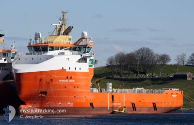
ARCTIC TIDE
Multi Purpose Offshore Vessel
Current Trip
| Trip Time | 1 day |
|---|---|
| Trip Distance | 137.32 nm |
| AVG Speed | 10.3 Knots |
| MAX Speed | 13.3 Knots |
| Draught | 0 m |
| AVG Wind | 20.7 knots |
| MAX Wind | 30 knots |
| MIN Temp | 6.3°C / 43.34°F |
| MAX Temp | 9.5°C / 49.1°F |
| Position Received | 2 m ago |
Current Position
| Longitude | --- |
|---|---|
| Latitude | --- |
| Status | Moored |
| Speed | |
| Course | 279° |
| Area | North Sea |
| Station | T-AIS |
| Position Received | 2 m ago |
Info
Information
The current position of ARCTIC TIDE is in North Sea with coordinates 58.92464° / 5.59435° as reported on 2025-12-06 00:11 by AIS to our vessel tracker app. The vessel's current speed is 0 Knots and is currently inside the port of TANANGER.
The vessel ARCTIC TIDE (IMO: 9592812, MMSI: 259989000) is a Multi Purpose Offshore Vessel that was built in 2012 ( 13 years old ). It's sailing under the flag of [NO] Norway.
In this page you can find informations about the vessels current position, last detected port calls, and current voyage information. If the vessels is not in coverage by AIS you will find the latest position.
The current position of ARCTIC TIDE is detected by our AIS receivers and we are not responsible for the reliability of the data. The last position was recorded while the vessel was in Coverage by the Ais receivers of our vessel tracking app.
Weather
| Temperature | 7.1°C / 44.78°F |
|---|---|
| Wind Speed | 22 knots |
| Direction | 123° ESE |
| Pressure | 1007.2 hPa |
| Humidity | 84.4 % |
| Cloud Coverage | 100 % |
Featured Company
Last Port Calls
| Port | Arrival | Departure | Time In Port |
|---|---|---|---|
| 2025-12-05 19:41 | |||
| 2025-12-03 08:22 | 2025-12-04 07:31 | 23 h | |
| 2025-11-30 02:51 | 2025-11-30 19:53 | 17 h | |
| 2025-11-26 03:07 | 2025-11-26 18:08 | 15 h | |
| 2025-11-20 16:10 | 2025-11-21 23:42 | 1 d | |
| 2025-11-16 19:26 | 2025-11-17 21:35 | 1 d | |
| 2025-11-11 07:13 | 2025-11-13 02:18 | 1 d | |
| 2025-11-09 14:03 | 2025-11-10 01:08 | 11 h | |
| 2025-11-07 07:41 | 2025-11-07 19:20 | 11 h | |
| 2025-11-05 07:13 | 2025-11-05 19:12 | 11 h |
Most Visited Ports (Last year)
| Port | Arrivals | |
|---|---|---|
| 90 | ||
| 13 | ||
| 8 | ||
| 4 | ||
| 3 | ||
| 1 |
Last Trips
| Origin | Departure | Destination | Arrival | Distance | |
|---|---|---|---|---|---|
| 2025-12-04 07:31 | 2025-12-05 19:41 | 137.32 nm | |||
| 2025-11-30 19:53 | 2025-12-03 08:22 | 145.23 nm | |||
| 2025-11-26 18:08 | 2025-11-30 02:51 | 127.81 nm | |||
| 2025-11-21 23:42 | 2025-11-26 03:07 | 133.37 nm | |||
| 2025-11-17 21:35 | 2025-11-20 16:10 | 227.91 nm | |||
| 2025-11-13 02:18 | 2025-11-16 19:26 | 314.36 nm | |||
| 2025-11-10 01:08 | 2025-11-11 07:13 | 228.01 nm | |||
| 2025-11-07 19:20 | 2025-11-09 14:03 | 251.17 nm | |||
| 2025-11-05 19:12 | 2025-11-07 07:41 | 228.90 nm | |||
| 2025-11-01 16:58 | 2025-11-05 07:13 | 231.63 nm |
Events
| Time | Event | Details | Position / Dest | Info |
|---|---|---|---|---|
| 2025-12-05 20:17 | ETA Changed | 2025/12/07 07:00 2025/12/05 18:00 |
58.92464 / 5.59432
[NO] TANANGER
|
Speed: Course: 279° |
| 2025-12-05 20:11 | Destination Changed | DEEPSEA NORDKAPP NO RIV |
58.92464 / 5.59434
[NO] TANANGER
|
Speed: Course: 279° |
| 2025-12-05 19:30 | Status Changed | Moored Under way using engine |
58.92464 / 5.59434
[NO] TANANGER
|
Speed: 0.1 kn Course: 279° |
| 2025-12-05 18:59 | STOP Moving |
58.92471 / 5.59417
[NO] TANANGER
|
Speed: 0.3 kn Course: 279° |
|
| 2025-12-05 18:41 | PORT ARRIVAL |
|
58.92970 / 5.57198
[NO] TANANGER
|
Speed: 8.7 kn Course: 126.5° |
| 2025-12-05 12:46 | Destination Changed | NO RIV DEEPSEA NORDKAPP |
58.79330 / 3.90088
NO RIV
|
Speed: 10.2 kn Course: 76.6° |
| 2025-12-05 12:46 | ETA Changed | 2025/12/05 18:00 2025/12/04 16:00 |
58.79330 / 3.90088
NO RIV
|
Speed: 10.2 kn Course: 76.6° |
| 2025-12-05 11:33 | IN Coverage |
58.73695 / 3.54201
North Sea
|
Speed: 10.5 kn Course: 73.6° |
|
| 2025-12-04 11:52 | OUT of Coverage |
58.78349 / 3.80246
North Sea
DEEPSEA NORDKAPP
|
Speed: 11 kn Course: 264.2° |
|
| 2025-12-04 07:10 | ETA Changed | 2025/12/04 16:00 2025/12/04 19:00 |
58.85612 / 5.45159
DEEPSEA NORDKAPP
|
Speed: 10.9 kn Course: 265.1° |