

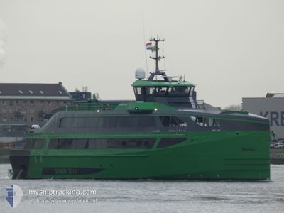
AQUA HELIX
High speed craft

Current Trip
| Trip Time | 12 h, 22 mins |
|---|---|
| Trip Distance | 41.12 nm |
| AVG Speed | 7.7 Knots |
| MAX Speed | 11.9 Knots |
| Draught | 4 m |
| AVG Wind | 6.4 knots |
| MAX Wind | 14.2 knots |
| MIN Temp | 25.7°C / 78.26°F |
| MAX Temp | 31.5°C / 88.7°F |
| Position Received | 2024-06-21 01:52 |
Current Position
| Longitude | --- |
|---|---|
| Latitude | --- |
| Status | Under way using engine |
| Speed | 16.9 Knots |
| Course | 193.2° |
| Area | South Atlantic Ocean |
| Station | T-AIS |
| Position Received | 2024-06-21 01:52 |
Information
The current position of AQUA HELIX is in South Atlantic Ocean with coordinates -9.78358° / -35.76011° as reported on 2024-06-21 01:52 by AIS to our vessel tracker app. The vessel's current speed is 16.9 Knots and is currently inside the port of BAJO GRANDE.
The vessel AQUA HELIX (IMO: 9885245, MMSI: 375143000) is a High speed craft It's sailing under the flag of [VC] St Vincent Grenadines.
In this page you can find informations about the vessels current position, last detected port calls, and current voyage information. If the vessels is not in coverage by AIS you will find the latest position.
The current position of AQUA HELIX is detected by our AIS receivers and we are not responsible for the reliability of the data. The last position was recorded while the vessel was in Coverage by the Ais receivers of our vessel tracking app.
The current draught of AQUA HELIX as reported by AIS is 4 meters
Weather
| Temperature | 26.8°C / 80.24°F |
|---|---|
| Wind Speed | 4 knots |
| Direction | 93° E |
| Pressure | 1011.2 hPa |
| Humidity | 72.2 % |
| Cloud Coverage | 96 % |


Featured Company
Last Port Calls
| Port | Arrival | Departure | Time In Port |
|---|---|---|---|
| 2025-03-26 17:32 | |||
| 2025-03-25 18:01 | 2025-03-26 05:10 | 11 h | |
| 2025-03-24 14:13 | 2025-03-25 10:32 | 20 h | |
| 2025-03-24 09:33 | 2025-03-24 11:34 | 2 h | |
| 2025-03-24 06:21 | 2025-03-24 08:16 | 1 h | |
| 2025-03-23 18:04 | 2025-03-24 05:39 | 11 h | |
| 2025-03-23 13:07 | 2025-03-23 17:17 | 4 h | |
| 2025-03-23 11:07 | 2025-03-23 12:32 | 1 h | |
| 2025-03-22 20:04 | 2025-03-23 09:29 | 13 h | |
| 2025-03-22 18:16 | 2025-03-22 18:51 | 34 m |
Most Visited Ports (Last year)
| Port | Arrivals | |
|---|---|---|
| 132 | ||
| 130 | ||
| 102 | ||
| 55 | ||
| 47 | ||
| 7 |
Last Trips
| Origin | Departure | Destination | Arrival | Distance | |
|---|---|---|---|---|---|
| 2025-03-26 05:10 | 2025-03-26 17:32 | 41.12 nm | |||
| 2025-03-25 10:32 | 2025-03-25 18:01 | 55.65 nm | |||
| 2025-03-24 11:34 | 2025-03-24 14:13 | 18.82 nm | |||
| 2025-03-24 08:16 | 2025-03-24 09:33 | 9.82 nm | |||
| 2025-03-24 05:39 | 2025-03-24 06:21 | 7.14 nm | |||
| 2025-03-23 17:17 | 2025-03-23 18:04 | 6.35 nm | |||
| 2025-03-23 12:32 | 2025-03-23 13:07 | 6.74 nm | |||
| 2025-03-23 09:29 | 2025-03-23 11:07 | 17.82 nm | |||
| 2025-03-22 18:51 | 2025-03-22 20:04 | 8.68 nm | |||
| 2025-03-22 09:56 | 2025-03-22 18:16 | 10.10 nm |
Events
| Time | Event | Details | Position / Dest | Info |
|---|---|---|---|---|
| 2025-03-26 22:13 | STOP Moving |
10.50767 / -71.60915
[VE] BAJO GRANDE
|
Speed: 0.2 kn Course: -1° |
|
| 2025-03-26 21:32 | PORT ARRIVAL |
|
10.50767 / -71.60915
[VE] BAJO GRANDE
|
Speed: 7.6 kn Course: 13° |
| 2025-03-26 09:10 | PORT DEPARTURE |
|
10.71463 / -71.55309
TMIB
|
Speed: Course: -1° |
| 2025-03-25 22:49 | STOP Moving |
10.63753 / -71.60804
[VE] MARACAIBO
|
Speed: Course: -1° |
|
| 2025-03-25 22:01 | PORT ARRIVAL |
|
10.63541 / -71.60243
[VE] MARACAIBO
|
Speed: 11.8 kn Course: 179° |
| 2025-03-25 15:16 | START Moving | 1.44 nm, East of MARACAIBO |
10.62820 / -71.57928
TMIB
|
Speed: 4.4 kn Course: -1° |
| 2025-03-25 14:58 | STOP Moving | 1.43 nm, East of MARACAIBO |
10.63087 / -71.57925
TMIB
|
Speed: 0.3 kn Course: -1° |
| 2025-03-25 14:32 | PORT DEPARTURE |
|
10.63274 / -71.59042
TMIB
|
Speed: 9 kn Course: -1° |
| 2025-03-25 14:28 | START Moving |
10.63501 / -71.59975
[VE] MARACAIBO
|
Speed: 9 kn Course: -1° |
|
| 2025-03-24 19:24 | STOP Moving |
10.63718 / -71.60804
[VE] MARACAIBO
|
Speed: Course: -1° |