
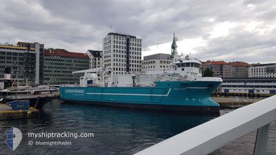
AQUA FJORD
General Cargo
Current Trip
FISHFARMS
| Time Travelled | 2 days |
|---|---|
| Remaining Time | --- |
| Distance Travelled | 326.13 nm |
| Remaining Distance | --- |
| AVG Speed | 10.6 Knots |
| MAX Speed | 13 Knots |
| AVG Wind | 20.3 knots |
| MAX Wind | 33.5 knots |
| MIN Temp | -2°C / 28.4°F |
| MAX Temp | 7.5°C / 45.5°F |
| Draught | 5 m |
| Position Received | Now |
Current Position
| Longitude | --- |
|---|---|
| Latitude | --- |
| Status | Under way using engine |
| Speed | |
| Course | --- |
| Area | Norwegian Sea |
| Station | T-AIS |
| Position Received | Now |
Info
Information
The current position of AQUA FJORD is in Norwegian Sea with coordinates 66.74480° / 13.49960° as reported on 2025-01-20 04:42 by AIS to our vessel tracker app. The vessel's current speed is 0 Knots
The vessel AQUA FJORD (IMO: 9295787, MMSI: 258031000) is a General Cargo that was built in 2004 ( 21 years old ). It's sailing under the flag of [NO] Norway.
In this page you can find informations about the vessels current position, last detected port calls, and current voyage information. If the vessels is not in coverage by AIS you will find the latest position.
The current position of AQUA FJORD is detected by our AIS receivers and we are not responsible for the reliability of the data. The last position was recorded while the vessel was in Coverage by the Ais receivers of our vessel tracking app.
The current draught of AQUA FJORD as reported by AIS is 5 meters
Weather
| Temperature | -8.3°C / 17.06°F |
|---|---|
| Wind Speed | 9 knots |
| Direction | 83° E |
| Pressure | 1026 hPa |
| Humidity | 79.3 % |
| Cloud Coverage | 70 % |
Featured Company
Last Port Calls
| Port | Arrival | Departure | Time In Port |
|---|---|---|---|
| 2025-01-17 10:26 | 2025-01-18 01:12 | 14 h | |
| 2025-01-16 19:17 | 2025-01-16 20:55 | 1 h | |
| 2025-01-16 14:01 | 2025-01-16 18:28 | 4 h | |
| 2025-01-16 09:37 | 2025-01-16 13:21 | 3 h | |
| 2025-01-15 08:16 | 2025-01-15 10:08 | 1 h | |
| 2025-01-12 06:13 | 2025-01-12 06:21 | 8 m | |
| 2025-01-08 23:56 | 2025-01-09 03:56 | 3 h | |
| 2025-01-08 20:48 | 2025-01-08 22:33 | 1 h | |
| 2025-01-05 11:53 | 2025-01-05 12:02 | 8 m | |
| 2025-01-03 14:52 | 2025-01-03 15:08 | 16 m |
Most Visited Ports (Last year)
| Port | Arrivals | |
|---|---|---|
| 29 | ||
| 23 | ||
| 18 | ||
| 16 | ||
| 10 | ||
| 6 |
Last Trips
| Origin | Departure | Destination | Arrival | Distance | |
|---|---|---|---|---|---|
| 2025-01-16 21:55 | 2025-01-17 11:26 | 64.94 nm | |||
| 2025-01-16 19:28 | 2025-01-16 20:17 | 8.52 nm | |||
| 2025-01-16 14:21 | 2025-01-16 15:01 | 6.05 nm | |||
| 2025-01-15 11:08 | 2025-01-16 10:37 | 187.71 nm | |||
| 2025-01-12 07:21 | 2025-01-15 09:16 | 392.51 nm | |||
| 2025-01-09 04:56 | 2025-01-12 07:13 | 475.63 nm | |||
| 2025-01-08 23:33 | 2025-01-09 00:56 | 15.60 nm | |||
| 2025-01-05 13:02 | 2025-01-08 21:48 | 497.39 nm | |||
| 2025-01-03 16:08 | 2025-01-05 12:53 | 82.25 nm | |||
| 2025-01-03 10:19 | 2025-01-03 15:52 | 37.22 nm |
Events
| Time | Event | Details | Position / Dest | Info |
|---|---|---|---|---|
| 2025-01-19 14:24 | STOP Moving | 8.73 nm, South West of ORNES |
66.74553 / 13.50028
FISHFARMS
|
Speed: 0.3 kn Course: 183° |
| 2025-01-19 14:11 | START Moving | 8.64 nm, North East of JEKTVIK |
66.75037 / 13.45474
FISHFARMS
|
Speed: 5.9 kn Course: 88.6° |
| 2025-01-19 13:16 | STOP Moving | 8.53 nm, North East of JEKTVIK |
66.75005 / 13.44628
FISHFARMS
|
Speed: 0.3 kn Course: 239° |
| 2025-01-18 19:52 | START Moving | 13.94 nm, North of LYSOYSUND |
64.11328 / 9.98214
FISHFARMS
|
Speed: 9.8 kn Course: 131.4° |
| 2025-01-18 18:27 | STOP Moving | 14.09 nm, North of LYSOYSUND |
64.11634 / 9.97665
FISHFARMS
|
Speed: 0.2 kn Course: 38° |
| 2025-01-18 18:01 | START Moving | 11.84 nm, North of LYSOYSUND |
64.08379 / 9.88194
FISHFARMS
|
Speed: 4.5 kn Course: 174° |
| 2025-01-18 16:41 | STOP Moving | 12.04 nm, North of LYSOYSUND |
64.08713 / 9.87838
FISHFARMS
|
Speed: 0.1 kn Course: 46° |
| 2025-01-18 14:33 | START Moving | 17.24 nm, North West of VALSNESET |
63.99645 / 9.13112
FISHFARMS
|
Speed: 7.3 kn Course: 56.7° |
| 2025-01-18 13:41 | STOP Moving | 17.38 nm, North West of VALSNESET |
63.99565 / 9.12315
FISHFARMS
|
Speed: 0.3 kn Course: 324° |
| 2025-01-18 13:10 | START Moving | 15.36 nm, North West of VALSNESET |
63.94531 / 9.13800
FISHFARMS
|
Speed: 7.1 kn Course: 22.7° |