
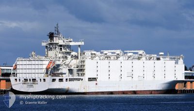
ANNA MARRA
Livestock Carrier
Current Trip
| Time Travelled | 38 days |
|---|---|
| Remaining Time | 10 h, 32 mins |
| Distance Travelled | 9295.73 nm |
| Remaining Distance | 85.93 nm |
| AVG Speed | 13.3 Knots |
| MAX Speed | 19.2 Knots |
| AVG Wind | 12.4 knots |
| MAX Wind | 38 knots |
| MIN Temp | 12°C / 53.6°F |
| MAX Temp | 29.9°C / 85.82°F |
| Draught | 8.3 m |
| Position Received | 8 d ago |
Current Position
| Longitude | -55.63245° |
|---|---|
| Latitude | -35.42593° |
| Status | Under way using engine |
| Speed | 1.2 Knots |
| Course | 231° |
| Area | Rio de La Plata |
| Station | T-AIS |
| Position Received | 8 d ago |
Info
Information
The current position of ANNA MARRA is in Rio de La Plata with coordinates -35.42593° / -55.63245° as reported on 2024-05-01 14:46 by AIS to our vessel tracker app. The vessel's current speed is 1.2 Knots and is heading at the port of MONTEVIDEO. The estimated time of arrival as calculated by MyShipTracking vessel tracking app is 2024-05-10 04:30 LT
The vessel ANNA MARRA (IMO: 8901860, MMSI: 353816000) is a Livestock Carrier that was built in 1990 ( 34 years old ). It's sailing under the flag of [PA] Panama.
In this page you can find informations about the vessels current position, last detected port calls, and current voyage information. If the vessels is not in coverage by AIS you will find the latest position.
The current position of ANNA MARRA is detected by our AIS receivers and we are not responsible for the reliability of the data. The last position was recorded while the vessel was in Coverage by the Ais receivers of our vessel tracking app.
The current draught of ANNA MARRA as reported by AIS is 8.3 meters
Weather
| Temperature | 12.9°C / 55.22°F |
|---|---|
| Wind Speed | 15 knots |
| Direction | 232° SW |
| Pressure | 1018.9 hPa |
| Humidity | 62.9 % |
| Cloud Coverage | --- |
Featured Company
Last Port Calls
| Port | Arrival | Departure | Time In Port |
|---|---|---|---|
| 2024-03-30 12:42 | 2024-03-31 22:27 | 1 d | |
| 2024-03-27 09:15 | 2024-03-28 19:05 | 1 d | |
| 2024-03-06 13:21 | 2024-03-11 08:33 | 4 d |
Most Visited Ports (Last year)
| Port | Arrivals | |
|---|---|---|
| 4 | ||
| 3 | ||
| 1 | ||
| 1 | ||
| 1 | ||
| 1 |
Last Trips
| Origin | Departure | Destination | Arrival | Distance | |
|---|---|---|---|---|---|
| 2024-03-28 22:05 | 2024-03-30 16:42 | 531.29 nm | |||
| 2024-03-11 16:33 | 2024-03-27 12:15 | 5487.97 nm | |||
| 2024-02-14 01:02 | 2024-03-06 21:21 | 5217.79 nm |
Events
| Time | Event | Details | Position / Dest | Info |
|---|---|---|---|---|
| 2024-05-08 11:46 | START Moving |
-35.71942 / -55.51982
UY MVD
|
Speed: 4.4 kn Course: 83° |
|
| 2024-05-08 00:03 | STOP Moving |
-35.80703 / -55.55642
UY MVD
|
Speed: 0.3 kn Course: 72° |
|
| 2024-05-06 23:03 | START Moving |
-35.46810 / -55.66427
UY MVD
|
Speed: 4.4 kn Course: 130° |
|
| 2024-05-05 05:37 | STOP Moving |
-35.65513 / -55.55998
UY MVD
|
Speed: 0.2 kn Course: 338° |
|
| 2024-05-04 19:51 | START Moving |
-35.99530 / -55.40512
UY MVD
|
Speed: 8.2 kn Course: 353° |
|
| 2024-05-04 00:57 | STOP Moving |
-35.61047 / -55.45075
UY MVD
|
Speed: 0.3 kn Course: 112° |
|
| 2024-05-03 23:35 | START Moving |
-35.48610 / -55.43196
UY MVD
|
Speed: 3.7 kn Course: 189° |
|
| 2024-05-03 12:43 | STOP Moving |
-35.58260 / -55.45692
UY MVD
|
Speed: 0.1 kn Course: 187° |
|
| 2024-05-03 05:56 | START Moving |
-35.34073 / -55.28521
UY MVD
|
Speed: 3.5 kn Course: 115° |
|
| 2024-05-02 20:54 | STOP Moving |
-35.51042 / -55.39155
UY MVD
|
Speed: 0.1 kn Course: 122° |