
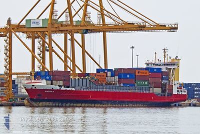
ANDREA
Container Ship
Current Trip
| Time Travelled | 18 h, 15 mins |
|---|---|
| Remaining Time | 8 h, 3 mins |
| Distance Travelled | 214.47 nm |
| Remaining Distance | 136.69 nm |
| AVG Speed | 12 Knots |
| MAX Speed | 14.5 Knots |
| AVG Wind | 13.7 knots |
| MAX Wind | 29 knots |
| MIN Temp | 11.4°C / 52.52°F |
| MAX Temp | 17.6°C / 63.68°F |
| Draught | 7.9 m |
| Position Received | 13 h, 35 m ago |
Current Position
| Longitude | --- |
|---|---|
| Latitude | --- |
| Status | Under way using engine |
| Speed | 12.9 Knots |
| Course | 88.1° |
| Area | Alboran Sea |
| Station | T-AIS |
| Position Received | 13 h, 35 m ago |
Info
Information
The current position of ANDREA is in Alboran Sea with coordinates 36.17636° / -4.31289° as reported on 2025-12-05 11:27 by AIS to our vessel tracker app. The vessel's current speed is 12.9 Knots and is heading at the port of ALICANTE. The estimated time of arrival as calculated by MyShipTracking vessel tracking app is 2025-12-06 10:06 LT
The vessel ANDREA (IMO: 9333357, MMSI: 255993000) is a Container Ship that was built in 2005 ( 20 years old ). It's sailing under the flag of [PT] Portugal.
In this page you can find informations about the vessels current position, last detected port calls, and current voyage information. If the vessels is not in coverage by AIS you will find the latest position.
The current position of ANDREA is detected by our AIS receivers and we are not responsible for the reliability of the data. The last position was recorded while the vessel was in Coverage by the Ais receivers of our vessel tracking app.
The current draught of ANDREA as reported by AIS is 7.9 meters
Weather
| Temperature | 17.5°C / 63.5°F |
|---|---|
| Wind Speed | 9 knots |
| Direction | 224° SW |
| Pressure | 1021.1 hPa |
| Humidity | 83.4 % |
| Cloud Coverage | 5 % |
Featured Company
Last Port Calls
| Port | Arrival | Departure | Time In Port |
|---|---|---|---|
| 2025-12-04 18:04 | 2025-12-05 07:48 | 13 h | |
| 2025-12-02 06:18 | 2025-12-02 18:23 | 12 h | |
| 2025-11-30 02:59 | 2025-12-01 19:55 | 1 d | |
| 2025-11-29 13:07 | 2025-11-29 20:39 | 7 h | |
| 2025-11-27 19:11 | 2025-11-28 14:29 | 19 h | |
| 2025-11-25 05:19 | 2025-11-26 11:47 | 1 d | |
| 2025-11-23 07:58 | 2025-11-24 17:15 | 1 d | |
| 2025-11-22 19:11 | 2025-11-23 02:18 | 7 h | |
| 2025-11-21 07:12 | 2025-11-21 18:55 | 11 h | |
| 2025-11-17 20:18 | 2025-11-19 02:19 | 1 d |
Last Trips
| Origin | Departure | Destination | Arrival | Distance | |
|---|---|---|---|---|---|
| 2025-12-02 18:23 | 2025-12-04 18:04 | 180.32 nm | |||
| 2025-12-01 19:55 | 2025-12-02 06:18 | 116.99 nm | |||
| 2025-11-29 20:39 | 2025-11-30 02:59 | 69.60 nm | |||
| 2025-11-28 14:29 | 2025-11-29 13:07 | 315.34 nm | |||
| 2025-11-26 11:47 | 2025-11-27 19:11 | 194.82 nm | |||
| 2025-11-24 17:15 | 2025-11-25 05:19 | 116.47 nm | |||
| 2025-11-23 02:18 | 2025-11-23 07:58 | 71.35 nm | |||
| 2025-11-21 18:55 | 2025-11-22 19:11 | 315.58 nm | |||
| 2025-11-19 02:19 | 2025-11-21 07:12 | 577.81 nm | |||
| 2025-11-17 18:27 | 2025-11-17 20:18 | 23.10 nm |
Events
| Time | Event | Details | Position / Dest | Info |
|---|---|---|---|---|
| 2025-12-05 11:29 | Status Changed | Default Under way using engine |
36.17648 / -4.30392
ESALC
|
Speed: 12.9 kn Course: 88.1° |
| 2025-12-05 11:27 | OUT of Coverage |
36.17636 / -4.31289
Alboran Sea
ESALC
|
Speed: 12.9 kn Course: 88.1° |
|
| 2025-12-05 08:40 | Change Sea Area | Spanish part of the Alboran Sea Gibraltarian part of the Alboran Sea |
36.11390 / -5.00868
Alboran Sea
ESALC
|
Speed: 11.8 kn Course: 84.7° |
| 2025-12-05 07:25 | Change Sea Area | Gibraltarian part of the Alboran Sea Gibraltarian part of the Strait of Gibraltar |
36.08638 / -5.32704
Alboran Sea
ESALC
|
Speed: 12 kn Course: 85.7° |
| 2025-12-05 07:07 | Change Sea Area | Gibraltarian part of the Strait of Gibraltar Spanish part of the Strait of Gibraltar |
36.11620 / -5.38727
Strait of Gibraltar
ESALC
|
Speed: 11.8 kn Course: 149.9° |
| 2025-12-05 06:48 | PORT DEPARTURE |
|
36.14937 / -5.42859
ESALC
|
Speed: 5.5 kn Course: 72° |
| 2025-12-05 06:40 | START Moving |
36.13702 / -5.43374
[ES] ALGECIRAS
|
Speed: 4.7 kn Course: 3° |
|
| 2025-12-05 06:17 | Status Changed | Under way using engine Moored |
36.13646 / -5.43601
[ES] ALGECIRAS
|
Speed: Course: 182° |
| 2025-12-04 17:48 | Draught Changed | 7.9 7.5 |
36.13642 / -5.43601
[ES] ALGECIRAS
|
Speed: Course: 182° |
| 2025-12-04 17:48 | Destination Changed | ESALC ESALG |
36.13642 / -5.43601
[ES] ALGECIRAS
|
Speed: Course: 182° |