
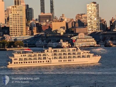
AMERICAN LIBERTY
Passenger
Current Trip
| Trip Time | 1 day |
|---|---|
| Trip Distance | 41.72 nm |
| AVG Speed | 8 Knots |
| MAX Speed | 12.3 Knots |
| Draught | 2.1 m |
| AVG Wind | 6.3 knots |
| MAX Wind | 8.8 knots |
| MIN Temp | 12.1°C / 53.78°F |
| MAX Temp | 23.3°C / 73.94°F |
| Position Received | 4 m ago |
Current Position
| Longitude | --- |
|---|---|
| Latitude | --- |
| Status | Moored |
| Speed | |
| Course | 179° |
| Area | North Atlantic Ocean |
| Station | T-AIS |
| Position Received | 4 m ago |
Info
Information
The current position of AMERICAN LIBERTY is in North Atlantic Ocean with coordinates 31.15079° / -81.50011° as reported on 2025-03-02 14:29 by AIS to our vessel tracker app. The vessel's current speed is 0 Knots and is currently inside the port of BRUNSWICK.
The vessel AMERICAN LIBERTY (MMSI: 368366750) is a Passenger It's sailing under the flag of [US] USA.
In this page you can find informations about the vessels current position, last detected port calls, and current voyage information. If the vessels is not in coverage by AIS you will find the latest position.
The current position of AMERICAN LIBERTY is detected by our AIS receivers and we are not responsible for the reliability of the data. The last position was recorded while the vessel was in Coverage by the Ais receivers of our vessel tracking app.
The current draught of AMERICAN LIBERTY as reported by AIS is 2.1 meters
Weather
| Temperature | 12.7°C / 54.86°F |
|---|---|
| Wind Speed | 7 knots |
| Direction | 21° NNE |
| Pressure | 1019 hPa |
| Humidity | 46.3 % |
| Cloud Coverage | 31 % |
Featured Company
Last Port Calls
| Port | Arrival | Departure | Time In Port |
|---|---|---|---|
| 2025-03-02 00:37 | |||
| 2025-02-26 23:45 | 2025-02-28 11:36 | 1 d | |
| 2025-02-25 00:13 | 2025-02-26 10:28 | 1 d | |
| 2025-02-21 14:30 | 2025-02-23 08:07 | 1 d | |
| 2025-02-17 21:40 | 2025-02-19 13:58 | 1 d | |
| 2025-02-16 01:34 | 2025-02-17 09:52 | 1 d | |
| 2025-02-13 00:51 | 2025-02-14 12:15 | 1 d | |
| 2025-02-11 00:37 | 2025-02-12 10:28 | 1 d | |
| 2025-02-07 14:18 | 2025-02-08 20:24 | 1 d | |
| 2025-02-03 21:36 | 2025-02-05 10:30 | 1 d |
Most Visited Ports (Last year)
| Port | Arrivals | |
|---|---|---|
| 15 | ||
| 12 | ||
| 7 | ||
| 6 | ||
| 6 | ||
| 6 |
Last Trips
| Origin | Departure | Destination | Arrival | Distance | |
|---|---|---|---|---|---|
| 2025-02-28 06:36 | 2025-03-01 19:37 | 41.72 nm | |||
| 2025-02-26 05:28 | 2025-02-26 18:45 | 81.23 nm | |||
| 2025-02-23 03:07 | 2025-02-24 19:13 | 37.39 nm | |||
| 2025-02-19 08:58 | 2025-02-21 09:30 | 83.40 nm | |||
| 2025-02-17 04:52 | 2025-02-17 16:40 | 93.36 nm | |||
| 2025-02-14 07:15 | 2025-02-15 20:34 | 58.44 nm | |||
| 2025-02-12 05:28 | 2025-02-12 19:51 | 79.62 nm | |||
| 2025-02-08 15:24 | 2025-02-10 19:37 | 64.83 nm | |||
| 2025-02-05 05:30 | 2025-02-07 09:18 | 121.96 nm | |||
| 2025-02-03 07:13 | 2025-02-03 16:36 | 60.03 nm |
Events
| Time | Event | Details | Position / Dest | Info |
|---|---|---|---|---|
| 2025-03-02 01:31 | Status Changed | Moored Under way using engine |
31.15080 / -81.50012
[US] BRUNSWICK
|
Speed: Course: 180° |
| 2025-03-02 01:01 | STOP Moving |
31.15070 / -81.50055
[US] BRUNSWICK
|
Speed: 0.2 kn Course: 49° |
|
| 2025-03-02 00:38 | Destination Changed | BRUNSWICK, GA FERNANDINA BCH, FL |
31.11034 / -81.46964
[US] BRUNSWICK
|
Speed: 12.4 kn Course: 292° |
| 2025-03-02 00:38 | ETA Changed | 2025/03/02 00:00 2026/02/28 14:00 |
31.11034 / -81.46964
[US] BRUNSWICK
|
Speed: 12.4 kn Course: 292° |
| 2025-03-02 00:37 | PORT ARRIVAL |
|
31.10992 / -81.46838
[US] BRUNSWICK
|
Speed: 12.3 kn Course: 292.8° |
| 2025-03-02 00:31 | IN Coverage |
31.10153 / -81.44637
North Atlantic Ocean
|
Speed: 11.2 kn Course: 295.2° |
|
| 2025-03-01 20:01 | OUT of Coverage |
30.78342 / -81.49215
North Atlantic Ocean
|
Speed: 7.3 kn Course: 340.7° |
|
| 2025-03-01 19:07 | IN Coverage |
30.67550 / -81.46622
North Atlantic Ocean
|
Speed: 5.7 kn Course: 13.9° |
|
| 2025-03-01 13:17 | OUT of Coverage |
30.67211 / -81.46615
North Atlantic Ocean
|
Speed: Course: 7.2° |
|
| 2025-03-01 00:26 | IN Coverage |
30.67211 / -81.46617
North Atlantic Ocean
|
Speed: Course: 334° |