
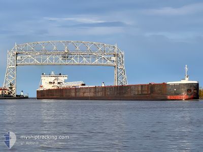
AMERICAN CENTURY
Self Discharging Bulk Carrier
Current Trip
| Time Travelled | 18 h, 29 mins |
|---|---|
| Remaining Time | --- |
| Distance Travelled | 185.99 nm |
| Remaining Distance | --- |
| AVG Speed | 12 Knots |
| MAX Speed | 12.8 Knots |
| AVG Wind | 14.1 knots |
| MAX Wind | 16 knots |
| MIN Temp | 15.4°C / 59.72°F |
| MAX Temp | 23.5°C / 74.3°F |
| Draught | 7.5 m |
| Position Received | 12 h, 35 m ago |
Current Position
| Longitude | -87.33267° |
|---|---|
| Latitude | 42.82684° |
| Status | Under way using engine |
| Speed | 12 Knots |
| Course | 0.5° |
| Area | --- |
| Station | T-AIS |
| Position Received | 12 h, 35 m ago |
Info
Information
The current position of AMERICAN CENTURY is in --- with coordinates 42.82684° / -87.33267° as reported on 2024-07-06 04:21 by AIS to our vessel tracker app. The vessel's current speed is 12 Knots and is heading at the port of TWO HARBORS. The estimated time of arrival as calculated by MyShipTracking vessel tracking app is 2024-07-08 10:00 LT
The vessel AMERICAN CENTURY (IMO: 7923196, MMSI: 367121010) is a Self Discharging Bulk Carrier that was built in 1981 ( 43 years old ). It's sailing under the flag of [US] USA.
In this page you can find informations about the vessels current position, last detected port calls, and current voyage information. If the vessels is not in coverage by AIS you will find the latest position.
The current position of AMERICAN CENTURY is detected by our AIS receivers and we are not responsible for the reliability of the data. The last position was recorded while the vessel was in Coverage by the Ais receivers of our vessel tracking app.
The current draught of AMERICAN CENTURY as reported by AIS is 7.5 meters
Weather
| Temperature | 15.8°C / 60.44°F |
|---|---|
| Wind Speed | 5 knots |
| Direction | 327° NNW |
| Pressure | 1013.1 hPa |
| Humidity | 85 % |
| Cloud Coverage | 85 % |
Featured Company
Last Port Calls
| Port | Arrival | Departure | Time In Port |
|---|---|---|---|
| 2024-07-05 08:03 | 2024-07-05 22:27 | 14 h | |
| 2024-07-03 17:31 | 2024-07-03 20:26 | 2 h | |
| 2024-07-01 08:15 | 2024-07-02 09:35 | 1 d | |
| 2024-06-30 01:53 | 2024-06-30 02:50 | 57 m | |
| 2024-06-28 19:59 | 2024-06-28 23:17 | 3 h | |
| 2024-06-27 20:07 | 2024-06-28 07:32 | 11 h | |
| 2024-06-26 01:15 | 2024-06-26 02:45 | 1 h | |
| 2024-06-24 05:23 | 2024-06-24 20:35 | 15 h | |
| 2024-06-23 02:17 | 2024-06-23 03:11 | 53 m | |
| 2024-06-21 17:19 | 2024-06-21 22:58 | 5 h |
Most Visited Ports (Last year)
| Port | Arrivals | |
|---|---|---|
| 77 | ||
| 32 | ||
| 25 | ||
| 17 | ||
| 9 | ||
| 9 |
Last Trips
| Origin | Departure | Destination | Arrival | Distance | |
|---|---|---|---|---|---|
| 2024-07-03 16:26 | 2024-07-05 03:03 | 384.52 nm | |||
| 2024-07-02 04:35 | 2024-07-03 13:31 | 343.39 nm | |||
| 2024-06-29 22:50 | 2024-07-01 03:15 | 336.09 nm | |||
| 2024-06-28 19:17 | 2024-06-29 21:53 | 285.33 nm | |||
| 2024-06-28 03:32 | 2024-06-28 15:59 | 141.39 nm | |||
| 2024-06-25 22:45 | 2024-06-27 16:07 | 429.21 nm | |||
| 2024-06-24 15:35 | 2024-06-25 21:15 | 322.96 nm | |||
| 2024-06-22 23:11 | 2024-06-24 00:23 | 318.11 nm | |||
| 2024-06-21 18:58 | 2024-06-22 22:17 | 302.56 nm | |||
| 2024-06-21 08:51 | 2024-06-21 13:19 | 34.08 nm |
Events
| Time | Event | Details | Position / Dest | Info |
|---|---|---|---|---|
| 2024-07-06 04:34 | Status Changed | Default Under way using engine |
42.86927 / -87.33208
TWO HARBORS
|
Speed: 12 kn Course: 0.5° |
| 2024-07-06 04:21 | OUT of Coverage |
42.82684 / -87.33267
TWO HARBORS
|
Speed: 12 kn Course: 0.5° |
|
| 2024-07-06 04:18 | Status Changed | Under way using engine Default |
42.81672 / -87.33274
TWO HARBORS
|
Speed: 12 kn Course: 0° |
| 2024-07-06 04:09 | Status Changed | Default Under way using engine |
42.78590 / -87.33291
TWO HARBORS
|
Speed: 12.1 kn Course: 0.5° |
| 2024-07-06 03:58 | Status Changed | Under way using engine Default |
42.74934 / -87.33317
TWO HARBORS
|
Speed: 12.1 kn Course: 0° |
| 2024-07-06 03:40 | IN Coverage |
42.75047 / -87.33316
TWO HARBORS
|
Speed: 12.1 kn Course: 0.4° |
|
| 2024-07-06 02:27 | Status Changed | Default Under way using engine |
42.43933 / -87.33433
TWO HARBORS
|
Speed: 12.6 kn Course: 1° |
| 2024-07-06 02:21 | OUT of Coverage |
42.41896 / -87.33459
TWO HARBORS
|
Speed: 12.6 kn Course: 1° |
|
| 2024-07-05 22:56 | Destination Changed | TWO HARBORS GARY |
41.71085 / -87.33522
TWO HARBORS
|
Speed: 11.9 kn Course: 348.3° |
| 2024-07-05 22:56 | ETA Changed | 2024/07/08 10:00 2024/07/05 08:30 |
41.71085 / -87.33522
TWO HARBORS
|
Speed: 11.9 kn Course: 348.3° |