
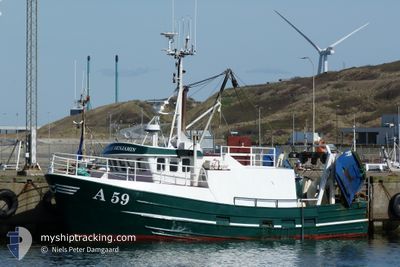
AMALIE BENJAMIN A59
Fishing
Current Trip
| Trip Time | 12 h, 58 mins |
|---|---|
| Trip Distance | 42.18 nm |
| AVG Speed | 6.1 Knots |
| MAX Speed | 8.2 Knots |
| Draught | 3 m |
| AVG Wind | 13.9 knots |
| MAX Wind | 18.5 knots |
| MIN Temp | 6.3°C / 43.34°F |
| MAX Temp | 7°C / 44.6°F |
| Position Received | 6 m ago |
Current Position
| Longitude | --- |
|---|---|
| Latitude | --- |
| Status | Engaged in Fishing |
| Speed | |
| Course | 119° |
| Area | Kattegat |
| Station | T-AIS |
| Position Received | 6 m ago |
Info
Information
The current position of AMALIE BENJAMIN A59 is in Kattegat with coordinates 57.71526° / 10.58272° as reported on 2025-12-07 00:19 by AIS to our vessel tracker app. The vessel's current speed is 0 Knots and is currently inside the port of SKAGEN.
The vessel AMALIE BENJAMIN A59 (MMSI: 219005867) is a Fishing It's sailing under the flag of [DK] Denmark.
In this page you can find informations about the vessels current position, last detected port calls, and current voyage information. If the vessels is not in coverage by AIS you will find the latest position.
The current position of AMALIE BENJAMIN A59 is detected by our AIS receivers and we are not responsible for the reliability of the data. The last position was recorded while the vessel was in Coverage by the Ais receivers of our vessel tracking app.
The current draught of AMALIE BENJAMIN A59 as reported by AIS is 3 meters
Weather
| Temperature | 6°C / 42.8°F |
|---|---|
| Wind Speed | 18 knots |
| Direction | 126° SE |
| Pressure | 1005.7 hPa |
| Humidity | 90.7 % |
| Cloud Coverage | 100 % |
Featured Company
Last Port Calls
| Port | Arrival | Departure | Time In Port |
|---|---|---|---|
| 2025-12-06 18:40 | |||
| 2025-12-05 18:27 | 2025-12-06 05:42 | 11 h | |
| 2025-12-04 18:34 | 2025-12-05 05:38 | 11 h | |
| 2025-12-03 17:10 | 2025-12-04 05:30 | 12 h | |
| 2025-11-26 19:27 | 2025-12-03 05:43 | 6 d | |
| 2025-11-19 21:41 | 2025-11-26 05:32 | 6 d | |
| 2025-11-18 20:04 | 2025-11-19 05:23 | 9 h | |
| 2025-11-15 20:01 | 2025-11-18 05:38 | 2 d | |
| 2025-11-14 18:19 | 2025-11-15 05:06 | 10 h | |
| 2025-11-11 18:20 | 2025-11-14 05:49 | 2 d |
Last Trips
| Origin | Departure | Destination | Arrival | Distance | |
|---|---|---|---|---|---|
| 2025-12-06 05:42 | 2025-12-06 18:40 | 42.18 nm | |||
| 2025-12-05 05:38 | 2025-12-05 18:27 | 27.82 nm | |||
| 2025-12-04 05:30 | 2025-12-04 18:34 | 13.49 nm | |||
| 2025-12-03 05:43 | 2025-12-03 17:10 | 14.56 nm | |||
| 2025-11-26 05:32 | 2025-11-26 19:27 | 46.18 nm | |||
| 2025-11-19 05:23 | 2025-11-19 21:41 | 19.33 nm | |||
| 2025-11-18 05:38 | 2025-11-18 20:04 | 13.37 nm | |||
| 2025-11-15 05:06 | 2025-11-15 20:01 | 26.49 nm | |||
| 2025-11-14 05:49 | 2025-11-14 18:19 | 24.90 nm | |||
| 2025-11-11 05:43 | 2025-11-11 18:20 | 35.31 nm |
Events
| Time | Event | Details | Position / Dest | Info |
|---|---|---|---|---|
| 2025-12-07 00:19 | IN Coverage |
57.71526 / 10.58272
Kattegat
[DK] SKAGEN
|
Speed: Course: 325.9° |
|
| 2025-12-06 18:55 | OUT of Coverage |
57.71527 / 10.58275
Kattegat
[DK] SKAGEN
|
Speed: Course: 24.6° |
|
| 2025-12-06 18:55 | IN Coverage |
57.71527 / 10.58275
Kattegat
[DK] SKAGEN
|
Speed: Course: 24.6° |
|
| 2025-12-06 17:46 | OUT of Coverage |
57.72044 / 10.59298
Kattegat
[DK] SKAGEN
|
Speed: Course: 284.8° |
|
| 2025-12-06 17:46 | STOP Moving |
57.72044 / 10.59298
[DK] SKAGEN
|
Speed: Course: 238° |
|
| 2025-12-06 17:40 | PORT ARRIVAL |
|
57.71356 / 10.60094
[DK] SKAGEN
|
Speed: 7.8 kn Course: 236.1° |
| 2025-12-06 17:11 | Change Sea Area | Danish part of the Kattegat Danish part of the Skaggerak |
57.74670 / 10.69040
Kattegat
|
Speed: 6.6 kn Course: 192.4° |
| 2025-12-06 16:49 | IN Coverage |
57.76196 / 10.66546
Skaggerak
|
Speed: 5 kn Course: 86.4° |
|
| 2025-12-06 09:54 | OUT of Coverage |
57.84112 / 10.16825
Skaggerak
|
Speed: 2.4 kn Course: 299.8° |
|
| 2025-12-06 08:34 | IN Coverage |
57.81691 / 10.25831
Skaggerak
|
Speed: 2.4 kn Course: 279.8° |