
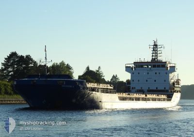
AIKATERINI K
General Cargo
Current Trip
| Time Travelled | 9 days |
|---|---|
| Remaining Time | --- |
| Distance Travelled | 2023.03 nm |
| Remaining Distance | --- |
| AVG Speed | 8.1 Knots |
| MAX Speed | 12.4 Knots |
| AVG Wind | 15.8 knots |
| MAX Wind | 33.8 knots |
| MIN Temp | 8.3°C / 46.94°F |
| MAX Temp | 17.9°C / 64.22°F |
| Draught | 4.5 m |
| Position Received | 39 m ago |
Current Position
| Longitude | -7.08301° |
|---|---|
| Latitude | 36.07966° |
| Status | Under way using engine |
| Speed | 11.1 Knots |
| Course | 105.1° |
| Area | North Atlantic Ocean |
| Station | T-AIS |
| Position Received | 39 m ago |
Info
Information
The current position of AIKATERINI K is in North Atlantic Ocean with coordinates 36.07966° / -7.08301° as reported on 2024-05-06 21:33 by AIS to our vessel tracker app. The vessel's current speed is 11.1 Knots and is heading at the port of ALGER. The estimated time of arrival as calculated by MyShipTracking vessel tracking app is 2024-05-09 18:00 LT
The vessel AIKATERINI K (IMO: 9381407, MMSI: 352001310) is a General Cargo that was built in 2008 ( 16 years old ). It's sailing under the flag of [PA] Panama.
In this page you can find informations about the vessels current position, last detected port calls, and current voyage information. If the vessels is not in coverage by AIS you will find the latest position.
The current position of AIKATERINI K is detected by our AIS receivers and we are not responsible for the reliability of the data. The last position was recorded while the vessel was in Coverage by the Ais receivers of our vessel tracking app.
The current draught of AIKATERINI K as reported by AIS is 4.5 meters
Weather
| Temperature | 17.9°C / 64.22°F |
|---|---|
| Wind Speed | 9 knots |
| Direction | 278° W |
| Pressure | 1016.8 hPa |
| Humidity | 78.6 % |
| Cloud Coverage | --- |
Featured Company
Events
| Time | Event | Details | Position / Dest | Info |
|---|---|---|---|---|
| 2024-05-06 21:36 | Status Changed | Default Under way using engine |
36.07679 / -7.06991
ALGER
|
Speed: 11.1 kn Course: 105.1° |
| 2024-05-06 21:13 | Status Changed | Under way using engine Default |
36.09860 / -7.16861
ALGER
|
Speed: 10.8 kn Course: 104° |
| 2024-05-06 21:09 | Status Changed | Default Under way using engine |
36.09860 / -7.16861
ALGER
|
Speed: 10.7 kn Course: 104.4° |
| 2024-05-06 21:03 | Status Changed | Under way using engine Default |
36.10299 / -7.18969
ALGER
|
Speed: 10.7 kn Course: 104° |
| 2024-05-06 20:56 | Status Changed | Default Under way using engine |
36.10667 / -7.21333
ALGER
|
Speed: 10.7 kn Course: 104° |
| 2024-05-06 20:46 | Status Changed | Under way using engine Default |
36.11655 / -7.25586
ALGER
|
Speed: 10.5 kn Course: 104° |
| 2024-05-06 19:54 | Status Changed | Default Under way using engine |
36.15534 / -7.43590
ALGER
|
Speed: 10.5 kn Course: 105.7° |
| 2024-05-06 19:49 | Detected in Sea | Spanish part of the North Atlantic Ocean |
36.15889 / -7.45187
North Atlantic Ocean
ALGER
|
Speed: 10.5 kn Course: 105.7° |
| 2024-05-06 19:35 | Status Changed | Under way using engine Default |
36.17050 / -7.50375
ALGER
|
Speed: 10.6 kn Course: 106° |
| 2024-05-06 19:30 | Status Changed | Default Under way using engine |
36.17412 / -7.51902
ALGER
|
Speed: 10.5 kn Course: 106.4° |