
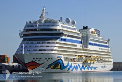
AIDASTELLA
Passengers Ship
Current Trip
| Time Travelled | 7 h, 34 mins |
|---|---|
| Remaining Time | 5 h, 51 mins |
| Distance Travelled | 100.10 nm |
| Remaining Distance | 86.47 nm |
| AVG Speed | 11.6 Knots |
| MAX Speed | 15.7 Knots |
| AVG Wind | 7.7 knots |
| MAX Wind | 20.3 knots |
| MIN Temp | 24.2°C / 75.56°F |
| MAX Temp | 26.2°C / 79.16°F |
| Draught | 7.2 m |
| Position Received | 1 m ago |
Current Position
| Longitude | 10.06880° |
|---|---|
| Latitude | 41.57554° |
| Status | Under way using engine |
| Speed | 15.1 Knots |
| Course | 68° |
| Area | Tyrrhenian Sea |
| Station | T-AIS |
| Position Received | 1 m ago |
Info
Information
The current position of AIDASTELLA is in Tyrrhenian Sea with coordinates 41.57554° / 10.06880° as reported on 2024-08-20 23:14 by AIS to our vessel tracker app. The vessel's current speed is 15.1 Knots and is heading at the port of CIVITAVECCHIA. The estimated time of arrival as calculated by MyShipTracking vessel tracking app is 2024-08-21 05:06 LT
The vessel AIDASTELLA (IMO: 9601132, MMSI: 247322800) is a Passengers Ship that was built in 2013 ( 11 years old ). It's sailing under the flag of [IT] Italy.
In this page you can find informations about the vessels current position, last detected port calls, and current voyage information. If the vessels is not in coverage by AIS you will find the latest position.
The current position of AIDASTELLA is detected by our AIS receivers and we are not responsible for the reliability of the data. The last position was recorded while the vessel was in Coverage by the Ais receivers of our vessel tracking app.
The current draught of AIDASTELLA as reported by AIS is 7.2 meters
Weather
| Temperature | 25.7°C / 78.26°F |
|---|---|
| Wind Speed | 16 knots |
| Direction | 273° W |
| Pressure | 1011.3 hPa |
| Humidity | 77.9 % |
| Cloud Coverage | 2 % |
Featured Company
Last Port Calls
| Port | Arrival | Departure | Time In Port |
|---|---|---|---|
| 2024-08-20 05:09 | 2024-08-20 15:41 | 10 h | |
| 2024-08-18 01:43 | 2024-08-18 20:48 | 19 h | |
| 2024-08-17 05:23 | 2024-08-17 17:23 | 11 h | |
| 2024-08-15 02:54 | 2024-08-15 15:50 | 12 h | |
| 2024-08-13 05:54 | 2024-08-13 18:19 | 12 h | |
| 2024-08-12 05:07 | 2024-08-12 18:41 | 13 h | |
| 2024-08-11 06:09 | 2024-08-11 17:07 | 10 h | |
| 2024-08-10 04:54 | 2024-08-10 15:21 | 10 h | |
| 2024-08-08 01:40 | 2024-08-08 20:06 | 18 h | |
| 2024-08-07 06:09 | 2024-08-07 17:17 | 11 h |
Most Visited Ports (Last year)
| Port | Arrivals | |
|---|---|---|
| 23 | ||
| 21 | ||
| 21 | ||
| 21 | ||
| 16 | ||
| 13 |
Last Trips
| Origin | Departure | Destination | Arrival | Distance | |
|---|---|---|---|---|---|
| 2024-08-18 22:48 | 2024-08-20 07:09 | 361.64 nm | |||
| 2024-08-17 19:23 | 2024-08-18 03:43 | 71.14 nm | |||
| 2024-08-15 17:50 | 2024-08-17 07:23 | 323.37 nm | |||
| 2024-08-13 20:19 | 2024-08-15 04:54 | 284.69 nm | |||
| 2024-08-12 20:41 | 2024-08-13 07:54 | 153.42 nm | |||
| 2024-08-11 19:07 | 2024-08-12 07:07 | 172.97 nm | |||
| 2024-08-10 17:21 | 2024-08-11 08:09 | 223.09 nm | |||
| 2024-08-08 22:06 | 2024-08-10 06:54 | 418.73 nm | |||
| 2024-08-07 19:17 | 2024-08-08 03:40 | 138.16 nm | |||
| 2024-08-06 19:47 | 2024-08-07 08:09 | 148.20 nm |
Events
| Time | Event | Details | Position / Dest | Info |
|---|---|---|---|---|
| 2024-08-20 22:27 | Change Sea Area | French part of the Tyrrhenian Sea Italian part of the Tyrrhenian Sea |
41.48827 / 9.84495
Tyrrhenian Sea
IT CVV
|
Speed: 14.9 kn Course: 49.9° |
| 2024-08-20 21:48 | Change Sea Area | Italian part of the Tyrrhenian Sea French part of the Tyrrhenian Sea |
41.43930 / 9.66905
Tyrrhenian Sea
IT CVV
|
Speed: 13.7 kn Course: 99° |
| 2024-08-20 21:37 | Change Sea Area | French part of the Tyrrhenian Sea Italian part of the Tyrrhenian Sea |
41.43414 / 9.61008
Tyrrhenian Sea
IT CVV
|
Speed: 14.9 kn Course: 67.8° |
| 2024-08-20 20:51 | Change Sea Area | Italian part of the Tyrrhenian Sea French part of the Mediterranean Sea - Western Basin |
41.35902 / 9.37529
Tyrrhenian Sea
IT CVV
|
Speed: 14.8 kn Course: 53.6° |
| 2024-08-20 20:51 | Status Changed | Under way using engine Default |
41.35902 / 9.37529
IT CVV
|
Speed: 14.8 kn Course: 51° |
| 2024-08-20 20:37 | IN Coverage |
41.35902 / 9.37529
Tyrrhenian Sea
IT CVV
|
Speed: 14.8 kn Course: 53.6° |
|
| 2024-08-20 19:35 | Status Changed | Default Under way using engine |
41.30410 / 9.01662
IT CVV
|
Speed: 14.9 kn Course: 113.5° |
| 2024-08-20 19:28 | OUT of Coverage |
41.31484 / 8.98162
Mediterranean Sea - Western Basin
IT CVV
|
Speed: 14.9 kn Course: 113.5° |
|
| 2024-08-20 18:48 | Status Changed | Under way using engine Default |
41.39253 / 8.79702
IT CVV
|
Speed: 14.5 kn Course: 139° |
| 2024-08-20 18:07 | Status Changed | Default Under way using engine |
41.51995 / 8.65108
IT CVV
|
Speed: 15.7 kn Course: 153.7° |