
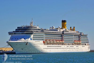
ADORA MEDITERRANEA
Passengers Ship
Current Trip
| Time Travelled | 16 h, 18 mins |
|---|---|
| Remaining Time | 1 day |
| Distance Travelled | 237.14 nm |
| Remaining Distance | 523.26 nm |
| AVG Speed | 14.9 Knots |
| MAX Speed | 19.3 Knots |
| AVG Wind | 15.7 knots |
| MAX Wind | 22 knots |
| MIN Temp | 15.7°C / 60.26°F |
| MAX Temp | 17.5°C / 63.5°F |
| Draught | 8.1 m |
| Position Received | 12 h, 43 m ago |
Current Position
| Longitude | --- |
|---|---|
| Latitude | --- |
| Status | Under way using engine |
| Speed | 13.6 Knots |
| Course | 98.8° |
| Area | Yellow Sea |
| Station | T-AIS |
| Position Received | 12 h, 43 m ago |
Info
Information
The current position of ADORA MEDITERRANEA is in Yellow Sea with coordinates 38.78887° / 118.78736° as reported on 2024-10-01 13:52 by AIS to our vessel tracker app. The vessel's current speed is 13.6 Knots and is heading at the port of HAKATA. The estimated time of arrival as calculated by MyShipTracking vessel tracking app is 2024-10-03 06:17 LT
The vessel ADORA MEDITERRANEA (IMO: 9237345, MMSI: 311001086) is a Passengers Ship that was built in 2003 ( 21 years old ). It's sailing under the flag of [BS] Bahamas.
In this page you can find informations about the vessels current position, last detected port calls, and current voyage information. If the vessels is not in coverage by AIS you will find the latest position.
The current position of ADORA MEDITERRANEA is detected by our AIS receivers and we are not responsible for the reliability of the data. The last position was recorded while the vessel was in Coverage by the Ais receivers of our vessel tracking app.
The current draught of ADORA MEDITERRANEA as reported by AIS is 8.1 meters
Weather
| Temperature | 16.8°C / 62.24°F |
|---|---|
| Wind Speed | 12 knots |
| Direction | 3° N |
| Pressure | 1022.4 hPa |
| Humidity | 41.6 % |
| Cloud Coverage | 5 % |
Featured Company
Last Port Calls
| Port | Arrival | Departure | Time In Port |
|---|---|---|---|
| 2024-09-30 23:48 | 2024-10-01 10:17 | 10 h | |
| 2024-09-28 02:01 | 2024-09-28 12:20 | 10 h | |
| 2024-09-25 22:53 | 2024-09-26 08:21 | 9 h | |
| 2024-09-23 21:27 | 2024-09-24 06:45 | 9 h | |
| 2024-09-23 03:41 | 2024-09-23 12:13 | 8 h | |
| 2024-09-20 23:17 | 2024-09-21 08:25 | 9 h | |
| 2024-09-18 23:46 | 2024-09-19 09:22 | 9 h | |
| 2024-09-18 02:00 | 2024-09-18 12:17 | 10 h | |
| 2024-09-15 23:09 | 2024-09-16 08:09 | 8 h | |
| 2024-09-14 00:19 | 2024-09-14 09:28 | 9 h |
Last Trips
| Origin | Departure | Destination | Arrival | Distance | |
|---|---|---|---|---|---|
| 2024-09-28 21:20 | 2024-10-01 07:48 | 801.78 nm | |||
| 2024-09-26 16:21 | 2024-09-28 11:01 | 778.48 nm | |||
| 2024-09-24 15:45 | 2024-09-26 06:53 | 779.21 nm | |||
| 2024-09-23 21:13 | 2024-09-24 06:27 | 151.72 nm | |||
| 2024-09-21 16:25 | 2024-09-23 12:41 | 770.60 nm | |||
| 2024-09-19 18:22 | 2024-09-21 07:17 | 604.52 nm | |||
| 2024-09-18 21:17 | 2024-09-19 08:46 | 199.09 nm | |||
| 2024-09-16 16:09 | 2024-09-18 11:00 | 779.16 nm | |||
| 2024-09-14 18:28 | 2024-09-16 07:09 | 604.19 nm | |||
| 2024-09-13 21:08 | 2024-09-14 09:19 | 223.49 nm |
Events
| Time | Event | Details | Position / Dest | Info |
|---|---|---|---|---|
| 2024-10-01 14:11 | Status Changed | Default Under way using engine |
38.79033 / 118.96591
JP HKT
|
Speed: 13.6 kn Course: 98.8° |
| 2024-10-01 13:52 | OUT of Coverage |
38.78887 / 118.78736
Yellow Sea
|
Speed: 13.6 kn Course: 98.8° |
|
| 2024-10-01 13:13 | Change Sea Area | Chinese part of the Yellow Sea Japanese part of the Japan Sea |
38.79982 / 118.69024
Yellow Sea
|
Speed: 13.9 kn Course: 96.1° |
| 2024-10-01 13:13 | Status Changed | Under way using engine Default |
38.79989 / 118.68927
JP HKT
|
Speed: 13.9 kn Course: 96° |
| 2024-10-01 12:57 | IN Coverage |
38.79982 / 118.69024
Yellow Sea
|
Speed: 13.9 kn Course: 96.1° |
|
| 2024-10-01 10:17 | PORT DEPARTURE |
|
38.95526 / 117.88181
JP HKT
|
Speed: 12.5 kn Course: 101° |
| 2024-10-01 10:01 | START Moving |
38.96815 / 117.82003
[CN] TIANJIN
|
Speed: 5.9 kn Course: 141° |
|
| 2024-10-01 00:25 | STOP Moving |
38.97528 / 117.81554
[CN] TIANJIN
|
Speed: 0.1 kn Course: 283° |
|
| 2024-09-30 23:48 | PORT ARRIVAL |
|
38.95926 / 117.86742
[CN] TIANJIN
|
Speed: 11.6 kn Course: 282° |
| 2024-09-28 12:21 | OUT of Coverage |
33.64843 / 130.30326
Japan Sea
|
Speed: 14.9 kn Course: 290.4° |