
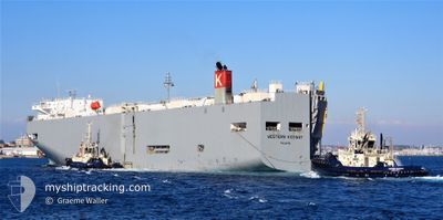
WESTERN HIGHWAY
Vehicles Carrier
Current Trip
| Time Travelled | 26 days |
|---|---|
| Remaining Time | --- |
| Distance Travelled | 7800.93 nm |
| Remaining Distance | --- |
| AVG Speed | 14.6 Knop |
| MAX Speed | 20.9 Knop |
| AVG Wind | 14 knots |
| MAX Wind | 29.8 knots |
| MIN Temp | 15.1°C / 59.18°F |
| MAX Temp | 30.1°C / 86.18°F |
| Djupgående | 8.1 m |
| Position mottagen | 6 d sen |
Current Position
| Longitud | --- |
|---|---|
| Latitude | --- |
| Status | Under way using engine |
| Fart | 14.5 Knop |
| Kurs | 191° |
| Område | South China Sea |
| Station | T-AIS |
| Position mottagen | 6 d sen |
Info
Information
The current position of WESTERN HIGHWAY is in South China Sea with coordinates 22.24605° / 113.80257° as reported on 2025-03-11 20:25 by AIS to our vessel tracker app. The vessel's current speed is 14.5 Knop and is heading at the port of LAZARO CARDENAS. The estimated time of arrival as calculated by MyShipTracking vessel tracking app is 2025-03-31 02:00 LT
The vessel WESTERN HIGHWAY (IMO: 9325776, MMSI: 372548000) is a Vehicles Carrier that was built in 2007 ( 18 År gammal ). It's sailing under the flag of [PA] Panama.
In this page you can find informations about the vessels current position, last detected port calls, and current voyage information. If the vessels is not in coverage by AIS you will find the latest position.
The current position of WESTERN HIGHWAY is detected by our AIS receivers and we are not responsible for the reliability of the data. The last position was recorded while the vessel was in Coverage by the Ais receivers of our vessel tracking app.
The current draught of WESTERN HIGHWAY as reported by AIS is 8.1 meters
Weather
| Temperature | 17.2°C / 62.96°F |
|---|---|
| Wind Speed | 9 knots |
| Direction | 299° WNW |
| Pressure | 1013.8 hPa |
| Humidity | 97.2 % |
| Cloud Coverage | 100 % |
Featured Company
Last Port Calls
| Port | Arrival | Departure | Time In Port |
|---|---|---|---|
| 2025-02-19 11:15 | 2025-02-19 23:14 | 11 h | |
| 2025-02-03 20:43 | 2025-02-04 15:10 | 18 h | |
| 2025-01-28 08:26 | 2025-01-29 10:10 | 1 d | |
| 2025-01-22 04:02 | 2025-01-23 16:53 | 1 d | |
| 2025-01-15 06:20 | 2025-01-15 19:21 | 13 h |
Last Trips
| Origin | Departure | Destination | Arrival | Distance | |
|---|---|---|---|---|---|
| 2025-02-04 15:10 | 2025-02-19 11:15 | 2252.93 nm | |||
| 2025-01-29 10:10 | 2025-02-03 20:43 | 814.05 nm | |||
| 2025-01-23 16:53 | 2025-01-28 08:26 | 760.76 nm | |||
| 2025-01-15 19:21 | 2025-01-22 04:02 | 508.03 nm | |||
| 2024-12-17 23:22 | 2025-01-15 06:20 | 5377.10 nm |
Events
| Tid | Event | Detaljer | Position / Dest | Information |
|---|---|---|---|---|
| 2025-03-11 20:25 | Status ändrad | Default Under way using engine |
22.24447 / 113.80218
MX LZC
|
Fart: 14.5 kn Kurs: 191° |
| 2025-03-11 20:25 | UTANFÖR täckningsområde |
22.24605 / 113.80257
South China Sea
MX LZC
|
Fart: 14.5 kn Kurs: 191° |
|
| 2025-03-11 18:35 | Djupgående ändrat | 8.1 7 |
22.64160 / 113.69455
MX LZC
|
Fart: 11.1 kn Kurs: 168° |
| 2025-03-11 18:35 | Destination ändrad | MX LZC CN NSA |
22.64160 / 113.69455
MX LZC
|
Fart: 11.1 kn Kurs: 168° |
| 2025-03-11 18:35 | ETA ändrat | 2025/03/31 08:00 2025/03/10 21:30 |
22.64160 / 113.69455
MX LZC
|
Fart: 11.1 kn Kurs: 168° |
| 2025-03-11 18:24 | Status ändrad | Under way using engine Default |
22.67577 / 113.68613
CN NSA
|
Fart: 11.5 kn Kurs: 165° |
| 2025-03-11 18:24 | I täckningsområde |
22.67577 / 113.68613
South China Sea
|
Fart: 11.5 kn Kurs: 167° |
|
| 2025-03-11 17:10 | STARTAR förflyttning | 4.77 nm, South West of DONG GUAN |
22.86633 / 113.55006
CN NSA
|
Fart: 5.8 kn Kurs: 0° |
| 2025-03-11 01:32 | STOPPAR förflyttning | 4.91 nm, South West of DONG GUAN |
22.86810 / 113.54433
CN NSA
|
Fart: 0.1 kn Kurs: 234° |
| 2025-03-10 23:52 | UTANFÖR täckningsområde |
22.67557 / 113.68685
South China Sea
CN NSA
|
Fart: 11.8 kn Kurs: 344° |