
VIKING POLARIS
Passenger
Current Trip
LEMINGTON
| Time Travelled | 12 h, 11 mins |
|---|---|
| Remaining Time | --- |
| Distance Travelled | 44.88 nm |
| Remaining Distance | --- |
| AVG Speed | 11.9 Knop |
| MAX Speed | 14.4 Knop |
| AVG Wind | 9.7 knots |
| MAX Wind | 14 knots |
| MIN Temp | 15.7°C / 60.26°F |
| MAX Temp | 18.6°C / 65.48°F |
| Djupgående | 6.1 m |
| Position mottagen | 6 m sen |
Current Position
| Longitud | --- |
|---|---|
| Latitude | --- |
| Status | At anchor |
| Fart | 0.1 Knop |
| Kurs | 188° |
| Område | Gulf of St-Lawrence |
| Station | T-AIS |
| Position mottagen | 6 m sen |
Info
Information
The current position of VIKING POLARIS is in Gulf of St-Lawrence with coordinates 42.00652° / -82.60463° as reported on 2024-10-06 11:02 by AIS to our vessel tracker app. The vessel's current speed is 0.1 Knop
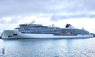
The vessel VIKING POLARIS (IMO: 9863209, MMSI: 259144000) is a Passenger It's sailing under the flag of [NO] Norway.
In this page you can find informations about the vessels current position, last detected port calls, and current voyage information. If the vessels is not in coverage by AIS you will find the latest position.
The current position of VIKING POLARIS is detected by our AIS receivers and we are not responsible for the reliability of the data. The last position was recorded while the vessel was in Coverage by the Ais receivers of our vessel tracking app.
The current draught of VIKING POLARIS as reported by AIS is 6.1 meters
Weather
| Temperature | 18.8°C / 65.84°F |
|---|---|
| Wind Speed | 18 knots |
| Direction | 198° SSW |
| Pressure | 1013.8 hPa |
| Humidity | 70.3 % |
| Cloud Coverage | 18 % |
Featured Company
Last Port Calls
| Port | Arrival | Departure | Time In Port |
|---|---|---|---|
| 2024-10-05 14:38 | 2024-10-05 22:58 | 8 h | |
| 2024-09-30 15:35 | 2024-10-02 19:23 | 2 d | |
| 2024-09-27 10:20 | 2024-09-27 18:56 | 8 h | |
| 2024-09-26 08:51 | 2024-09-26 20:51 | 11 h | |
| 2024-09-26 00:18 | 2024-09-26 01:19 | 1 h | |
| 2024-09-24 09:47 | 2024-09-25 22:06 | 1 d | |
| 2024-09-24 07:26 | 2024-09-24 08:07 | 40 m | |
| 2024-09-23 10:21 | 2024-09-23 20:45 | 10 h | |
| 2024-09-21 14:57 | 2024-09-21 23:08 | 8 h | |
| 2024-09-17 09:47 | 2024-09-18 19:31 | 1 d |
Most Visited Ports (Last year)
| Port | Arrivals | |
|---|---|---|
| 12 | ||
| 11 | ||
| 11 | ||
| 11 | ||
| 8 | ||
| 7 |
Last Trips
| Origin | Departure | Destination | Arrival | Distance | |
|---|---|---|---|---|---|
| 2024-10-02 14:23 | 2024-10-05 10:38 | 540.40 nm | |||
| 2024-09-27 14:56 | 2024-09-30 10:35 | 540.50 nm | |||
| 2024-09-26 16:51 | 2024-09-27 06:20 | 207.14 nm | |||
| 2024-09-25 21:19 | 2024-09-26 04:51 | 19.08 nm | |||
| 2024-09-25 18:06 | 2024-09-25 20:18 | 22.56 nm | |||
| 2024-09-24 04:07 | 2024-09-24 05:47 | 23.62 nm | |||
| 2024-09-23 16:45 | 2024-09-24 03:26 | 19.82 nm | |||
| 2024-09-21 19:08 | 2024-09-23 06:21 | 217.60 nm | |||
| 2024-09-18 14:31 | 2024-09-21 10:57 | 548.04 nm | |||
| 2024-09-16 00:14 | 2024-09-17 04:47 | 314.30 nm |
Events
| Tid | Event | Detaljer | Position / Dest | Information |
|---|---|---|---|---|
| 2024-10-06 09:32 | I täckningsområde |
42.00654 / -82.60475
Gulf of St-Lawrence
|
Fart: 0.1 kn Kurs: 252° |
|
| 2024-10-06 07:56 | UTANFÖR täckningsområde |
42.00654 / -82.60481
Gulf of St-Lawrence
|
Fart: Kurs: 94.9° |
|
| 2024-10-06 07:56 | I täckningsområde |
42.00654 / -82.60481
Gulf of St-Lawrence
|
Fart: Kurs: 94.9° |
|
| 2024-10-06 04:59 | UTANFÖR täckningsområde |
42.00648 / -82.60464
Gulf of St-Lawrence
LEMINGTON
|
Fart: Kurs: 130.4° |
|
| 2024-10-06 04:59 | Status ändrad | At anchor Default |
42.00648 / -82.60464
LEMINGTON
|
Fart: Kurs: 151° |
| 2024-10-06 04:29 | Status ändrad | Default At anchor |
42.00645 / -82.60516
LEMINGTON
|
Fart: 0.1 kn Kurs: 138° |
| 2024-10-06 03:44 | Status ändrad | At anchor Default |
42.00643 / -82.60515
LEMINGTON
|
Fart: Kurs: 130° |
| 2024-10-06 03:17 | Status ändrad | Default At anchor |
42.00639 / -82.60513
LEMINGTON
|
Fart: 0.2 kn Kurs: 129° |
| 2024-10-06 02:48 | Status ändrad | At anchor Under way using engine |
42.00565 / -82.60450
LEMINGTON
|
Fart: 0.5 kn Kurs: 115° |
| 2024-10-06 02:43 | STOPPAR förflyttning | 1.11 nm, South of LEAMINGTON |
42.00554 / -82.60396
LEMINGTON
|
Fart: 0.2 kn Kurs: 62° |