
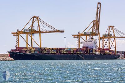
ULSAN
Container Ship
Current Trip
| Time Travelled | 3 days |
|---|---|
| Remaining Time | --- |
| Distance Travelled | 1320.94 nm |
| Remaining Distance | --- |
| AVG Speed | 13.6 Knop |
| MAX Speed | 19.8 Knop |
| AVG Wind | 15.9 knots |
| MAX Wind | 29 knots |
| MIN Temp | 14.8°C / 58.64°F |
| MAX Temp | 26.9°C / 80.42°F |
| Djupgående | 13 m |
| Position mottagen | 2 m sen |
Current Position
| Longitud | --- |
|---|---|
| Latitude | --- |
| Status | Moored |
| Fart | |
| Kurs | 329° |
| Område | South China Sea |
| Station | T-AIS |
| Position mottagen | 2 m sen |
Info
Information
The current position of ULSAN is in South China Sea with coordinates 20.78763° / 106.91580° as reported on 2026-01-06 13:39 by AIS to our vessel tracker app. The vessel's current speed is 0 Knop
The vessel ULSAN (IMO: 9243306, MMSI: 636022118) is a Container Ship that was built in 2002 ( 24 År gammal ). It's sailing under the flag of [LR] Liberia.
In this page you can find informations about the vessels current position, last detected port calls, and current voyage information. If the vessels is not in coverage by AIS you will find the latest position.
The current position of ULSAN is detected by our AIS receivers and we are not responsible for the reliability of the data. The last position was recorded while the vessel was in Coverage by the Ais receivers of our vessel tracking app.
The current draught of ULSAN as reported by AIS is 13 meters
Weather
| Temperature | 15.3°C / 59.54°F |
|---|---|
| Wind Speed | 6 knots |
| Direction | 42° NE |
| Pressure | 1025.4 hPa |
| Humidity | 58.2 % |
| Cloud Coverage | 100 % |
Featured Company
Last Port Calls
| Port | Arrival | Departure | Time In Port |
|---|---|---|---|
| 2026-01-02 06:42 | 2026-01-02 23:53 | 17 h | |
| 2025-12-31 09:00 | 2026-01-01 10:52 | 1 d | |
| 2025-12-19 12:01 | 2025-12-20 06:45 | 18 h | |
| 2025-12-18 06:34 | 2025-12-19 07:25 | 1 d | |
| 2025-12-05 05:52 | 2025-12-06 04:58 | 23 h | |
| 2025-12-03 08:26 | 2025-12-04 12:33 | 1 d | |
| 2025-11-20 16:27 | 2025-11-21 07:38 | 15 h | |
| 2025-11-19 07:52 | 2025-11-20 10:09 | 1 d | |
| 2025-11-06 11:49 | 2025-11-07 07:27 | 19 h | |
| 2025-11-05 03:36 | 2025-11-06 02:26 | 22 h |
Last Trips
| Origin | Departure | Destination | Arrival | Distance | |
|---|---|---|---|---|---|
| 2026-01-01 10:52 | 2026-01-02 06:42 | 177.74 nm | |||
| 2025-12-20 06:45 | 2025-12-31 09:00 | 2829.32 nm | |||
| 2025-12-19 07:25 | 2025-12-19 12:01 | 31.38 nm | |||
| 2025-12-06 04:58 | 2025-12-18 06:34 | 2846.85 nm | |||
| 2025-12-04 12:33 | 2025-12-05 05:52 | 143.17 nm | |||
| 2025-11-21 07:38 | 2025-12-03 08:26 | 2799.20 nm | |||
| 2025-11-20 10:09 | 2025-11-20 16:27 | 51.51 nm | |||
| 2025-11-07 07:27 | 2025-11-19 07:52 | 2846.06 nm | |||
| 2025-11-06 02:26 | 2025-11-06 11:49 | 64.57 nm | |||
| 2025-10-24 06:23 | 2025-11-05 03:36 | 2807.71 nm |
Events
| Tid | Event | Detaljer | Position / Dest | Information |
|---|---|---|---|---|
| 2026-01-06 10:18 | Status ändrad | Moored Default |
20.78758 / 106.91573
VN HPH
|
Fart: Kurs: 329° |
| 2026-01-06 10:15 | Status ändrad | Default Moored |
20.78753 / 106.91572
VN HPH
|
Fart: Kurs: 329° |
| 2026-01-06 08:54 | Status ändrad | Moored Default |
20.78755 / 106.91575
VN HPH
|
Fart: Kurs: 329° |
| 2026-01-06 08:51 | Status ändrad | Default Moored |
20.78737 / 106.91579
VN HPH
|
Fart: Kurs: 329° |
| 2026-01-06 05:45 | Status ändrad | Moored Under way using engine |
20.78758 / 106.91572
VN HPH
|
Fart: Kurs: 329° |
| 2026-01-06 05:40 | STOPPAR förflyttning | 10.9 nm, South East of HAI PHONG |
20.78768 / 106.91588
VN HPH
|
Fart: 0.3 kn Kurs: 327° |
| 2026-01-06 03:57 | ETA ändrat | 2026/01/06 04:00 2026/01/06 00:01 |
20.61973 / 106.93378
VN HPH
|
Fart: 11.9 kn Kurs: 71° |
| 2026-01-06 03:22 | Byter havsområde | Vietnamese part of the South China Sea Indonesian part of the Singapore Strait |
20.58263 / 106.92348
South China Sea
VN HPH
|
Fart: 9.4 kn Kurs: 342° |
| 2026-01-06 03:22 | Status ändrad | Under way using engine Default |
20.58263 / 106.92348
VN HPH
|
Fart: 10.6 kn Kurs: 340° |
| 2026-01-06 03:20 | I täckningsområde |
20.58263 / 106.92348
South China Sea
VN HPH
|
Fart: 9.4 kn Kurs: 342° |