

TROPIC SUN
General Cargo

Current Trip
GUYANA
| Time Travelled | 20 h, 15 mins |
|---|---|
| Remaining Time | --- |
| Distance Travelled | 204.15 nm |
| Remaining Distance | --- |
| AVG Speed | 9.8 Knop |
| MAX Speed | 12.9 Knop |
| AVG Wind | 14.5 knots |
| MAX Wind | 17 knots |
| MIN Temp | 21.9°C / 71.42°F |
| MAX Temp | 26.8°C / 80.24°F |
| Djupgående | 5.6 m |
| Position mottagen | 3 d sen |
Current Position
| Longitud | --- |
|---|---|
| Latitude | --- |
| Status | Under way using engine |
| Fart | 3.6 Knop |
| Kurs | 122° |
| Område | Caribbean Sea |
| Station | T-AIS |
| Position mottagen | 3 d sen |
Information
The current position of TROPIC SUN is in Caribbean Sea with coordinates 13.11074° / -59.67089° as reported on 2025-03-26 02:07 by AIS to our vessel tracker app. The vessel's current speed is 3.6 Knop
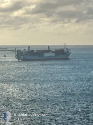
The vessel TROPIC SUN (IMO: 9039016, MMSI: 375902000) is a General Cargo that was built in 1992 ( 33 År gammal ). It's sailing under the flag of [VC] St Vincent Grenadines.
In this page you can find informations about the vessels current position, last detected port calls, and current voyage information. If the vessels is not in coverage by AIS you will find the latest position.
The current position of TROPIC SUN is detected by our AIS receivers and we are not responsible for the reliability of the data. The last position was recorded while the vessel was in Coverage by the Ais receivers of our vessel tracking app.
The current draught of TROPIC SUN as reported by AIS is 5.6 meters
Weather
| Temperature | 26.2°C / 79.16°F |
|---|---|
| Wind Speed | 16 knots |
| Direction | 63° ENE |
| Pressure | 1011.1 hPa |
| Humidity | 82 % |
| Cloud Coverage | 99 % |


Featured Company
Last Port Calls
| Port | Arrival | Departure | Time In Port |
|---|---|---|---|
| 2025-03-27 18:26 | 2025-03-28 05:43 | 11 h | |
| 2025-03-25 22:53 | 2025-03-26 08:05 | 9 h | |
| 2025-03-24 23:38 | 2025-03-25 07:26 | 7 h | |
| 2025-03-19 16:59 | 2025-03-20 03:27 | 10 h | |
| 2025-03-18 09:23 | 2025-03-19 12:25 | 1 d | |
| 2025-03-17 08:57 | 2025-03-17 19:24 | 10 h | |
| 2025-03-15 08:13 | 2025-03-16 18:15 | 1 d | |
| 2025-03-14 08:16 | 2025-03-14 18:35 | 10 h | |
| 2025-03-12 21:07 | 2025-03-13 18:25 | 21 h | |
| 2025-03-11 18:38 | 2025-03-11 23:48 | 5 h |
Most Visited Ports (Last year)
| Port | Arrivals | |
|---|---|---|
| 142 | ||
| 135 | ||
| 3 | ||
| 3 | ||
| 1 | ||
| 1 |
Last Trips
| Origin | Departure | Destination | Arrival | Distance | |
|---|---|---|---|---|---|
| 2025-03-26 08:05 | 2025-03-27 18:26 | 397.78 nm | |||
| 2025-03-25 07:26 | 2025-03-25 22:53 | 8.68 nm | |||
| 2025-03-20 03:27 | 2025-03-24 23:38 | 1445.22 nm | |||
| 2025-03-19 12:25 | 2025-03-19 16:59 | 19.12 nm | |||
| 2025-03-17 19:24 | 2025-03-18 09:23 | 188.56 nm | |||
| 2025-03-16 18:15 | 2025-03-17 08:57 | 186.22 nm | |||
| 2025-03-14 18:35 | 2025-03-15 08:13 | 185.88 nm | |||
| 2025-03-13 18:25 | 2025-03-14 08:16 | 185.54 nm | |||
| 2025-03-11 23:48 | 2025-03-12 21:07 | 10.39 nm | |||
| 2025-03-10 15:52 | 2025-03-11 18:38 | 193.37 nm |
Events
| Tid | Event | Detaljer | Position / Dest | Information |
|---|---|---|---|---|
| 2025-03-28 09:43 | STARTAR förflyttning | 2.09 nm, North of GEORGETOWN |
6.82409 / -58.17088
GUYANA
|
Fart: 10.5 kn Kurs: 10° |
| 2025-03-28 09:43 | AVGÅTT HAMN |
|
6.82409 / -58.17088
GUYANA
|
Fart: 3 kn Kurs: 272° |
| 2025-03-27 22:48 | STOPPAR förflyttning |
6.81292 / -58.16843
[GY] GEORGETOWN
|
Fart: 0.3 kn Kurs: 187° |
|
| 2025-03-27 22:26 | ANLÄNDER HAMN |
|
6.81801 / -58.16903
[GY] GEORGETOWN
|
Fart: 5.8 kn Kurs: 178° |
| 2025-03-26 12:05 | STARTAR förflyttning | 0.23 nm, West of BRIDGETOWN |
13.10896 / -59.63533
GUYANA
|
Fart: 5.1 kn Kurs: 260° |
| 2025-03-26 12:05 | AVGÅTT HAMN |
|
13.10896 / -59.63533
GUYANA
|
Fart: 0.8 kn Kurs: 343° |
| 2025-03-26 03:02 | STOPPAR förflyttning |
13.10679 / -59.63049
[BB] BRIDGETOWN
|
Fart: 0.2 kn Kurs: 341° |
|
| 2025-03-26 02:53 | ANLÄNDER HAMN |
|
13.10811 / -59.63174
[BB] BRIDGETOWN
|
Fart: 3.1 kn Kurs: 102° |
| 2025-03-26 02:18 | Status ändrad | Default Under way using engine |
13.10875 / -59.65796
GUYANA
|
Fart: 3.6 kn Kurs: 122° |
| 2025-03-26 02:07 | UTANFÖR täckningsområde |
13.11074 / -59.67089
Caribbean Sea
[BB] BRIDGETOWN
|
Fart: 3.6 kn Kurs: 123.3° |