
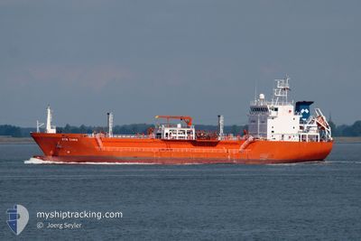
SYN ZANIA
Lpg Tanker
Current Trip
| Time Travelled | 17 h, 10 mins |
|---|---|
| Remaining Time | 53 mins |
| Distance Travelled | 200.94 nm |
| Remaining Distance | 12.61 nm |
| AVG Speed | 11.6 Knop |
| MAX Speed | 13 Knop |
| AVG Wind | 12.7 knots |
| MAX Wind | 16 knots |
| MIN Temp | 16.5°C / 61.7°F |
| MAX Temp | 21.4°C / 70.52°F |
| Djupgående | 5.3 m |
| Position mottagen | 1 m sen |
Current Position
| Longitud | -8.97390° |
|---|---|
| Latitude | 37.78918° |
| Status | Under way using engine |
| Fart | 10.9 Knop |
| Kurs | 26.4° |
| Område | North Atlantic Ocean |
| Station | T-AIS |
| Position mottagen | 1 m sen |
Info
Information
The current position of SYN ZANIA is in North Atlantic Ocean with coordinates 37.78918° / -8.97390° as reported on 2024-05-11 09:20 by AIS to our vessel tracker app. The vessel's current speed is 10.9 Knop and is heading at the port of SINES. The estimated time of arrival as calculated by MyShipTracking vessel tracking app is 2024-05-11 10:14 LT
The vessel SYN ZANIA (IMO: 9346938, MMSI: 247231200) is a Lpg Tanker that was built in 2008 ( 16 År gammal ). It's sailing under the flag of [IT] Italy.
In this page you can find informations about the vessels current position, last detected port calls, and current voyage information. If the vessels is not in coverage by AIS you will find the latest position.
The current position of SYN ZANIA is detected by our AIS receivers and we are not responsible for the reliability of the data. The last position was recorded while the vessel was in Coverage by the Ais receivers of our vessel tracking app.
The current draught of SYN ZANIA as reported by AIS is 5.3 meters
Weather
| Temperature | 16.5°C / 61.7°F |
|---|---|
| Wind Speed | 12 knots |
| Direction | 334° NNW |
| Pressure | 1016.5 hPa |
| Humidity | 91.8 % |
| Cloud Coverage | 13 % |
Featured Company
Last Port Calls
| Port | Arrival | Departure | Time In Port |
|---|---|---|---|
| 2024-05-09 16:56 | 2024-05-10 16:11 | 23 h | |
| 2024-05-06 14:18 | 2024-05-07 19:32 | 1 d | |
| 2024-04-27 19:21 | 2024-04-28 06:36 | 11 h | |
| 2024-04-26 15:22 | 2024-04-27 03:31 | 12 h | |
| 2024-04-24 12:23 | 2024-04-25 22:18 | 1 d | |
| 2024-04-21 00:26 | 2024-04-22 03:01 | 1 d | |
| 2024-04-16 18:32 | 2024-04-17 21:43 | 1 d | |
| 2024-04-15 18:16 | 2024-04-16 16:27 | 22 h | |
| 2024-04-11 09:17 | 2024-04-11 15:01 | 5 h | |
| 2024-04-09 18:02 | 2024-04-10 23:31 | 1 d |
Most Visited Ports (Last year)
| Port | Arrivals | |
|---|---|---|
| 8 | ||
| 8 | ||
| 7 | ||
| 7 | ||
| 6 | ||
| 5 |
Last Trips
| Origin | Departure | Destination | Arrival | Distance | |
|---|---|---|---|---|---|
| 2024-05-07 20:32 | 2024-05-09 18:56 | 245.57 nm | |||
| 2024-04-28 07:36 | 2024-05-06 15:18 | 889.81 nm | |||
| 2024-04-27 04:31 | 2024-04-27 20:21 | 106.13 nm | |||
| 2024-04-25 23:18 | 2024-04-26 16:22 | 120.21 nm | |||
| 2024-04-22 05:01 | 2024-04-24 13:23 | 650.83 nm | |||
| 2024-04-17 22:43 | 2024-04-21 02:26 | 779.76 nm | |||
| 2024-04-16 17:27 | 2024-04-16 19:32 | 14.10 nm | |||
| 2024-04-11 17:01 | 2024-04-15 19:16 | 806.56 nm | |||
| 2024-04-11 01:31 | 2024-04-11 11:17 | 21.92 nm | |||
| 2024-04-03 10:51 | 2024-04-09 20:02 | 1037.05 nm |
Events
| Tid | Event | Detaljer | Position / Dest | Information |
|---|---|---|---|---|
| 2024-05-10 19:14 | Byter havsområde | Portuguese part of the North Atlantic Ocean Spanish part of the North Atlantic Ocean |
36.90873 / -7.41699
North Atlantic Ocean
PTSIE
|
Fart: 11.8 kn Kurs: 252.9° |
| 2024-05-10 19:05 | Status ändrad | Under way using engine Default |
36.91932 / -7.35993
PTSIE
|
Fart: 11.8 kn Kurs: 259° |
| 2024-05-10 19:02 | Status ändrad | Default Under way using engine |
36.91759 / -7.37061
PTSIE
|
Fart: 11.9 kn Kurs: 258.9° |
| 2024-05-10 18:44 | Status ändrad | Under way using engine Default |
36.92933 / -7.29451
PTSIE
|
Fart: 12.2 kn Kurs: 259° |
| 2024-05-10 18:43 | Status ändrad | Default Under way using engine |
36.92997 / -7.29045
PTSIE
|
Fart: 12.2 kn Kurs: 258° |
| 2024-05-10 18:25 | Status ändrad | Under way using engine Default |
36.94331 / -7.21889
PTSIE
|
Fart: 12.2 kn Kurs: 258° |
| 2024-05-10 18:19 | Status ändrad | Default Under way using engine |
36.94816 / -7.19311
PTSIE
|
Fart: 12.6 kn Kurs: 260.9° |
| 2024-05-10 17:21 | ETA ändrat | 2024/05/11 09:00 2024/05/11 08:00 |
36.99166 / -6.94861
PTSIE
|
Fart: 12.5 kn Kurs: 242.3° |
| 2024-05-10 16:28 | Djupgående ändrat | 5.3 5.2 |
37.09640 / -6.82177
PTSIE
|
Fart: 10.1 kn Kurs: 163.1° |
| 2024-05-10 16:11 | AVGÅTT HAMN |
|
37.12209 / -6.83519
PTSIE
|
Fart: 7.7 kn Kurs: 160° |