
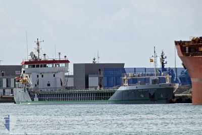
SOLENTBANK
General Cargo
Current Trip
| Time Travelled | 2 days |
|---|---|
| Remaining Time | --- |
| Distance Travelled | 522.04 nm |
| Remaining Distance | --- |
| AVG Speed | 11 Knop |
| MAX Speed | 11.8 Knop |
| AVG Wind | 11.7 knots |
| MAX Wind | 21 knots |
| MIN Temp | 10.6°C / 51.08°F |
| MAX Temp | 13.7°C / 56.66°F |
| Djupgående | 5.5 m |
| Position mottagen | 2 d sen |
Current Position
| Longitud | --- |
|---|---|
| Latitude | --- |
| Status | Under way using engine |
| Fart | 10.7 Knop |
| Kurs | 343.6° |
| Område | North Atlantic Ocean |
| Station | T-AIS |
| Position mottagen | 2 d sen |
Information
The current position of SOLENTBANK is in North Atlantic Ocean with coordinates 41.00221° / -9.20143° as reported on 2025-03-26 19:20 by AIS to our vessel tracker app. The vessel's current speed is 10.7 Knop and is heading at the port of LONDONDERRY. The estimated time of arrival as calculated by MyShipTracking vessel tracking app is 2025-03-30 17:00 LT
The vessel SOLENTBANK (IMO: 9361744, MMSI: 244854000) is a General Cargo that was built in 2007 ( 18 År gammal ). It's sailing under the flag of [NL] Netherlands.
In this page you can find informations about the vessels current position, last detected port calls, and current voyage information. If the vessels is not in coverage by AIS you will find the latest position.
The current position of SOLENTBANK is detected by our AIS receivers and we are not responsible for the reliability of the data. The last position was recorded while the vessel was in Coverage by the Ais receivers of our vessel tracking app.
The current draught of SOLENTBANK as reported by AIS is 5.5 meters
Weather
| Temperature | 10°C / 50°F |
|---|---|
| Wind Speed | 19 knots |
| Direction | 317° NW |
| Pressure | 1022.2 hPa |
| Humidity | 66.5 % |
| Cloud Coverage | 18 % |
Featured Company
Last Port Calls
| Port | Arrival | Departure | Time In Port |
|---|---|---|---|
| 2025-03-24 11:23 | 2025-03-26 14:23 | 2 d | |
| 2025-03-14 20:21 | 2025-03-16 07:11 | 1 d | |
| 2025-02-21 06:40 | 2025-03-13 13:14 | 20 d | |
| 2025-02-18 12:42 | 2025-02-19 23:30 | 1 d | |
| 2025-02-14 22:29 | |||
| 2025-02-11 13:42 | 2025-02-12 11:14 | 21 h | |
| 2025-02-07 04:41 | 2025-02-07 05:20 | 39 m | |
| 2025-02-07 04:00 | 2025-02-07 04:19 | 19 m | |
| 2025-02-05 13:03 | 2025-02-07 03:14 | 1 d | |
| 2025-02-05 12:02 | 2025-02-05 12:23 | 20 m |
Most Visited Ports (Last year)
| Port | Arrivals | |
|---|---|---|
| 10 | ||
| 8 | ||
| 7 | ||
| 4 | ||
| 2 | ||
| 2 |
Last Trips
| Origin | Departure | Destination | Arrival | Distance | |
|---|---|---|---|---|---|
| 2025-03-16 08:11 | 2025-03-24 11:23 | 1413.63 nm | |||
| 2025-03-13 14:14 | 2025-03-14 21:21 | 278.81 nm | |||
| 2025-02-20 00:30 | 2025-02-21 07:40 | 244.52 nm | |||
| 2025-02-14 22:29 | 2025-02-18 13:42 | 879.07 nm | |||
| 2025-02-07 05:20 | 2025-02-11 13:42 | 924.40 nm | |||
| 2025-02-07 04:19 | 2025-02-07 04:41 | 1.97 nm | |||
| 2025-02-07 03:14 | 2025-02-07 04:00 | 4.47 nm | |||
| 2025-02-05 12:23 | 2025-02-05 13:03 | 4.61 nm | |||
| 2025-02-01 15:04 | 2025-02-05 12:02 | 2.16 nm | |||
| 2025-01-29 01:22 | 2025-02-01 14:27 | 722.88 nm |
Events
| Tid | Event | Detaljer | Position / Dest | Information |
|---|---|---|---|---|
| 2025-03-26 19:34 | Status ändrad | Default Under way using engine |
41.04220 / -9.21367
LONDONDERRY
|
Fart: 10.7 kn Kurs: 343.6° |
| 2025-03-26 19:20 | Status ändrad | Under way using engine Default |
41.00221 / -9.20143
LONDONDERRY
|
Fart: 11.1 kn Kurs: 344° |
| 2025-03-26 19:20 | I täckningsområde |
41.00221 / -9.20143
North Atlantic Ocean
LONDONDERRY
|
Fart: 10.7 kn Kurs: 343.6° |
|
| 2025-03-26 19:20 | UTANFÖR täckningsområde |
41.00221 / -9.20143
North Atlantic Ocean
LONDONDERRY
|
Fart: 10.7 kn Kurs: 343.6° |
|
| 2025-03-26 17:45 | Status ändrad | Default Under way using engine |
40.71894 / -9.11031
LONDONDERRY
|
Fart: 11.4 kn Kurs: 345.5° |
| 2025-03-26 17:42 | UTANFÖR täckningsområde |
40.70836 / -9.10725
North Atlantic Ocean
LONDONDERRY
|
Fart: 11.4 kn Kurs: 345.5° |
|
| 2025-03-26 16:37 | Status ändrad | Under way using engine Default |
40.51376 / -9.04900
LONDONDERRY
|
Fart: 11.6 kn Kurs: 346° |
| 2025-03-26 15:52 | Status ändrad | Default Under way using engine |
40.37476 / -9.00419
LONDONDERRY
|
Fart: 11.3 kn Kurs: 347.7° |
| 2025-03-26 14:23 | AVGÅTT HAMN |
|
40.14103 / -8.87895
LONDONDERRY
|
Fart: 8.6 kn Kurs: 230° |
| 2025-03-26 14:11 | STARTAR förflyttning |
40.14670 / -8.84764
[PT] FIGUEIRA DA FOZ
|
Fart: 4 kn Kurs: 263° |